More From Contributor

£5.99
From the momentous to the outlandish, this little book brings together past & present to offer a taste of Liverpool. Learn about the movers & shakers who shaped this fantastic city. The great & the good; the bad & the ugly. Small wonders, tall stories, triumph & tragedy. Best places
- worst places. Origins, evolution, future. Written by a local who knows what makes Liverpool tick.
...
Archived Product
£8.99
Scousers believe they live in a special place, one that has more in common with Salvador da Bahia, New Orleans or Gdansk than anywhere in Engl&, & the city has always punched above its weight. In less than a hundred years, however, Liverpool`s image has declined from a major mercantile player known as the Second City of the Empire to what some social commentators have described as a cultural backwater remembered largely as the place where the Beatles were born. In ” Liverpool: The Hurricane Port”, Andrew Lees reveals how Liverpool`s pre-eminence in the slave trade left an indelible scar on the psychogeography of the city. He also explores the roots of Liverpool`s contrary nature, its rebelliousness & its hedonism, as well as some of the recent hurricanes that have battered the city, including the anger of Toxteth, the Hillsborough disaster & the murder of James Bulger. In this distinctly personal account, Lees defines the characteristics of this Celtic enclave, with her loudmouthed, big-hearted people who have created a city quite different from anywhere else in the world. ...
Archived Product
£2.95
Liversedge & North Heckmondwike in 1905 in a fascinating series of reproductions of old Ordnance Survey plans in the Alan Godfrey Editions, ideal for anyone interested in the history of their neighbourhood or family. Selected towns in Great Britain & Ireland are covered by maps showing the extent of urban development in the last decades of the 19th & early 20th century. In this title: the map covers parts of Liversedge & Heckmondwike, while the hamlet of White Lee is in the top right corner. Liversedge LYR station is in the bottom left corner. Features include Station Lane, Christ Church, Healds Hall, tramway depot, LNWR station, Victoria Mills, Well Fold, Thornbush Farm, Lower Popeley, Westfield; the portion of Heckmondwike

Includes::
Victoria Colliery, disused Ings Mill, Nunroyd, cemetery, Longfield Mills, Heckmondwike Chemical Works. To the east are The Crofts, White Lee Common, Dale Lane Top, New Brighton Mills, Ridings Mills, White Lee Colliery. At the top of the map is a portion of Gomersal, including Castle House, California Foundry, Union Mills. On the reverse is an 1889 directory of Liversedge. About the Alan Godfrey Editions of the 25

...
Archived Product
£8.99
The only novel from bestselling author Alice Munro, winner of the Nobel Prize in Literature Catching frogs, grazing knees, singing songs to save England from Hitler
- that was childhood for Del Jordan, & now she`s impatient for more. More than she can find in the encyclopedias sold by her mother, or in the half-understood innuendos dispensed by best friend Naomi, or in the whispers of boys during Friday night dances. Just like the girls in the movies, she wants to get started on real life. In her only novel, Alice Munro turns her eye to the frustrations, embarrassments, glee & bewilderment of adolescence, & to the brushes with sex, death, violence & birth that shape the lives of girls & women.
...
Archived Product
£19.99
The new Supertrail Maps show the best singletrails in Europe’s hottest mountain bike spots. These unique topographic maps make the knowledge of locals available to other mountain bikers. Consistent difficulty rating & useful additional information prevent the user from critical situations on the trails. The best singletrails in the best mountain bike spots throughout Europe
- this is the convincing formula of the brand new Supertrail Maps. For the first time ever, these unique topographic maps make the knowledge of locals available to others. All the trails on a map have been biked & rated in five difficulty levels for up- & downhill separately by specially trained authors. This consistent rating facilitates tour planning & spares a user from getting into sketchy situations on the trails. In addition to the difficulty rating, extraordinary nice trails are marked with a «highlight»-pictogram. The maps in a scale of 1:50 000 show all information required for tour planning & orienting oneself on the trails, such as: difficulty, highlight-trails, mountain railways with mountain bike transport, mountain bike shuttles, dangerous falls, restaurants, bike shops, emergency numbers & touristic infopoints. Thanks to the especially chosen map section, one map covers the whole area. The Supertrail Maps are printed on tear- & waterproof foil which makes them very sturdy. On the back of any map, additional information about the area & the use of a Supertrail Map are presented in two languages. Folded

Dimensions of 10x 15cm allow the map to fit into any pocket without squeezing.


...
Archived Product
£22.99
The best rides in the freeride hot spots of the Alps – this is the simple formula of the Freeride Maps. The first map available to freeriders is making the locals freeride knowledge available to a broad public. All ridable slopes, drops & couloirs are marked as freeride corridors in different colours for three difficulty ratings: blue for technically easy terrain, yellow requires advanced to very advanced ability & red is extremely difficult terrain that is partially exposed & therefore reserved to crack riders. Short ascents are marked with red lines. The Freeride Maps are based on topographic maps 1:25, 000. They contain all essential information about the terrain that is necessary for planning & going freeriding. The maps are printed on water resistant & indestructible paper. On the back side, the maps include all relevant planning, safety & rescue information. ...
Archived Product
£12.99
Whether you are a foreigner on holiday & exploring the possibilities of living in the United States, or whether you have already made up your mind to go there full-time, this easy-toread handbook will tell you how to go about it. It covers all you need to know about:
- How to obtain visas, whether for tourism or business
- How to obtain permanent residency, on a number of possible grounds
- Shipping your possessions & Customs & Excise
- Finding work & starting your own business
- Dealing with money matters & mortgages
- Educating your children at school & at college
- Personal security & how to stay safe
- Travelling around the States
- Opportunities for young people & teachers


...
Archived Product
£15.95
What`s it really like Living & Working in Australia? Not surprisingly, there`s more to life than barbies, beaches, beer & bronzed bodies. This book is guaranteed to hasten your introduction to the Australian way of life, irrespective of whether you`re planning to stay for a few months or indefinitely. Adjusting to day-to-day-life in Australia just got a whole lot simpler! ...
Archived Product
£15.95
What's it really like Living & Working in Britain? Not surprisingly, there's a lot more to life than castles, cricket & crumpets. This book is guaranteed to make your life in Britain easier & more enjoyable, irrespective of whether you're planning to stay for a few months or indefinitely. Adjusting to day-to-day-life in Britain just got a whole lot simpler! The most comprehensive & best-selling book about living in Britain since it was first published in 1991, containing up to twice as much information as some similar books. ...
Archived Product
£14.95
Living & Working in Canada is a comprehensive guide to the country & its customs & an up to date source of information for foreigners who need to be introduced to the Canadian way of life. The guide is organised into detailed chapters on finding a job, employment conditions, permits & visas, arrival, accommodation, postal services, telecommunications, television & radio, education, public transport, motoring, health, insurance, finance, leisure, sports, shopping, odds & ends, the Canadians, & moving house or leaving Canada. Also included are appendices listing useful addresses & websites, details concerning further reading & conversion amounts for weights & measures. ...
Archived Product

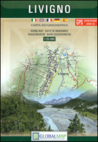
Livigno And Environs

Livigno and its environs on a detailed, contoured and GPS compatible map at 1:25, 000 from Litografia Artistica Cartographical in their Global Map imprint, highlighting hiking trails, huts, ski lifts, etc. The map is double-sided, with a very generous overlap, and extends from the Swiss approaches to the Lago di Livigno Dam to Rifigio Dosde, and from the Swiss border eastwards to Premadio and Valdisotto.The map has contours at 25m intervals, enhanced by relief shading and very effective graphic relief, with plenty of spot heights and names of mountain groups, peaks, passes, etc. An overprint highlights hiking trails, indicating mule tracks or easy paths, waymarked routes, and difficult waymarked trails, as well as alpine huts and cabins. Where appropriate, the overprint
extends onto the Swiss side of the border. Local roads show parking spaces. The map has a grid with latitude and longitude at 1’ intervals. Map legend includes English.
RIP - This product is no longer available on our network. It was last seen on 25.09.2019

This page now acts as a permanent archive for this product. Add more information using the comments box below to ensure it can still be found by future generations.

Use our search facility to see if it is available from an alternative contributor.
  • External links may include paid for promotion
  • Availability: Out Of Stock
  • Supplier: Stanfords
  • SKU: 9788879144872
Availability: In Stock
£12.99

Product Description

Livigno & its environs on a detailed, contoured & GPS compatible map at 1:25, 000 from Litografia Artistica Cartographical in their Global Map imprint, highlighting hiking trails, huts, ski lifts, etc. The map is double-sided, with a very generous overlap, & extends from the Swiss approaches to the Lago di Livigno Dam to Rifigio Dosde, & from the Swiss border eastwards to Premadio & Valdisotto. The map has contours at 25m intervals, enhanced by relief shading & very effective graphic relief, with plenty of spot heights & names of mountain groups, peaks, passes, etc. An overprint highlights hiking trails, indicating mule tracks or easy paths, waymarked routes, & difficult waymarked trails, as well as alpine huts & cabins. Where appropriate, the overprint extends onto the Swiss side of the border. Local roads show parking spaces. The map has a grid with latitude & longitude at 1’ intervals. Map legend

Includes::
English.

Reviews/Comments

Add New

Intelligent Comparison

Oooops!
We couldn't find anything!
Perhaps this product's unique.... Or perhaps we are still looking for comparisons!
Click to bump this page and we'll hurry up.

Price History

Vouchers

No voucher codes found.
Do you know a voucher code for this product or supplier? Add it to Insights for others to use.

Facebook

Jargon Buster

GPS - Global Positioning System - Global position using satellites
Hiking - An outdoor activity envolving walking in nature
swiss - Short for Switzerland, one of the richest countries in the world

Supplier Information

Stanfords
Stanfords was established in 1853 and opened their iconic Covent Garden flagship store in 1901. They have become the top retailer of maps, travel books and accessories in the UK and arguably offer the largest selection of maps and travel books worldwide. Famous names such as Captain Robert Falcon Scott, Ranulph Fiennes and Michael Palin have purchased from Stanfords. They now have a shop in Bristol and both stores together with other venues operate a calendar of events including talks, book signings and exhibitions. As a specialist map retailer, the map selection is comprehensive and includes road maps, street maps and walking maps from worldwide destinations, as well as a selection of world atlases and wall maps. Books include travel guides and travel literature. Stanfords also stock globes, from miniatures made of blue marble to magnificent floor-standing globes. The website features a selection of interesting articles on travel topics.
Page Updated: 2023-11-12 20:15:36

Community Generated Product Tags

Oh No! The productWIKI community hasn't generated any tags for this product yet!
Menu