
 United Kingdom
 France
 Germany
 Netherlands
 Sweden
 USA
USA
 Italy
Italy
 Spain
Spain
More From Contributor


London Premier Wall Map ENCAPSULATED
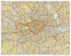
London Premier Wall Map, size 121 x 96cm, encapsulated version, from Geographers' A-Z Map Company at 3 inches to 1 mile (1:21, 477), designed to cover an area around at least a six-mile radius from Charing Cross, with a separate 124-page comprehensive index booklet listing streets, places and areas, industrial estates, selected flats and walkways, junction names and selected places of interest, shown where appropriate with their postcodes.The plan shows A and B roads annotated with selected house numbers for easier identification of addresses. One way traffic, restricted access, pedestrianized streets, junction names, selected car parks and the boundary of the Congestion Zone are marked. Railway, Underground, Docklands Light Railway and River Bus stations/stops are shown
with names. Colouring and/or symbols indicate public building, services and facilities, including shopping centres or market streets, industrial buildings, hospitals or healthcare, educational establishments, etc. Public toilets are marked, indicating those with facilities for the disabled. The map also shows local authority and postcode boundaries, plus national grid lines. The index is in a separate, 124-page booklet and includes additional lists of hospitals/walk-in medical centres/hospices, plus railway/Underground/Docklands Light Railway/river bus stations. This title is also available on paper, or as a folded map on paper or waterproof.LAMINATED and ENCAPSULATED WALL MAPS:- laminated wall maps have a thin layer of plastic usually applied to the printed side only. They can
be written on with suitable marker pens without any damage to the map but, unless laminated on both sides, they are not damp-proof.- encapsulated wall maps are sealed between two sheets of plastic. They are more rigid and heavier than laminated maps of the same size. They are damp-proof and do not crinkle in humid conditions. Encapsulation gives the map a shiny surface, similar to being displayed behind glass.- please note: many publishers and retailers often use these two terms interchangeably. Our map titles and descriptions follow the definitions provided above.
Product Description
Reviews/Comments
Add New
Intelligent Comparison
Archived Product

Leeds Premier Wall Map ENCAPSULATED Stanfords
£24.99
Archived Product
Liverpool Premier Wall Map ENCAPSULATED Stanfords
£24.99
Archived Product
Cardiff Premier Wall Map ENCAPSULATED Stanfords
£24.99
Archived Product
Glasgow Premier Wall Map ENCAPSULATED Stanfords
£24.99
Archived Product
Nottingham Premier Wall Map ENCAPSULATED Stanfords
£24.99
Archived Product
Plymouth Premier Wall Map ENCAPSULATED Stanfords
£24.99
Archived Product
London Premier Wall Map PAPER Stanfords
£6.99
Archived Product
Leicester Premier Wall Map ENCAPSULATED Stanfords
£24.99
Vouchers
No voucher codes found.
Do you know a voucher code for this product or supplier? Add it to Insights for others to use.
Do you know a voucher code for this product or supplier? Add it to Insights for others to use.
 Denmark