
 United Kingdom
 France
 Germany
 Netherlands
 Sweden
 USA
USA
 Italy
Italy
 Spain
Spain
More From Contributor


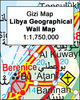


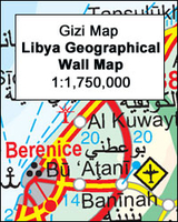
Libya Geographical Map
Libya at 1:1, 750, 000 on an indexed map from Gizi Map with bold altitude colouring to show its physical geography, oil and gas wells and pipelines, water aqueducts, ancients sites and other places of interest, etc. Names of larger towns and selected smaller locations, as well as of many topographic features are also shown in Arabic.The map provides a very fine presentation of the country’s geography through bold altitude colouring and graphics for sandy or stone deserts, swamps, salt flats, oasis, and water wells, plus numerous spot heights and plenty of names of mountain ranges, wadis, etc. Road network shows desert tracks and gives distances on main routes. Railway lines are included and domestic airports/aerodromes are marked. The map also shows oil or gas wells and
pipelines, water aqueducts and boundaries of administrative provinces. Symbols indicate locations with campsites or youth hostels, various places of interest including archaeological sites and natural curiosities, etc. Latitude and longitude lines are drawn at 1° intervals. The index is next to the map. Map legend includes English and Arabic. Also provided is a distance table.PLEASE NOTE: this map is also available in a road edition with altitude colouring replaced by relief shading to make the road network stand out better from the background – all other information is the same. Both versions are also published as wall maps.
pipelines, water aqueducts and boundaries of administrative provinces. Symbols indicate locations with campsites or youth hostels, various places of interest including archaeological sites and natural curiosities, etc. Latitude and longitude lines are drawn at 1° intervals. The index is next to the map. Map legend includes English and Arabic. Also provided is a distance table.PLEASE NOTE: this map is also available in a road edition with altitude colouring replaced by relief shading to make the road network stand out better from the background – all other information is the same. Both versions are also published as wall maps.

Product Description
Reviews/Comments
Add New
Intelligent Comparison
Archived Product

India Geographical Wall Map Stanfords
£13.50
Archived Product
Libya Geographical Edition Wall Map Stanfords
£13.50
Archived Product

Algeria Geographical Wall Map Stanfords
£13.50
Vouchers
No voucher codes found.
Do you know a voucher code for this product or supplier? Add it to Insights for others to use.
Do you know a voucher code for this product or supplier? Add it to Insights for others to use.
 Denmark