
 United Kingdom
 France
 Germany
 Netherlands
 Sweden
 USA
USA
 Italy
Italy
 Spain
Spain
More From Contributor


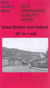
Ironbridge 1901
Ironbridge in 1901 in a fascinating series of reproductions of old Ordnance Survey plans in the Alan Godfrey Editions, ideal for anyone interested in the history of their neighbourhood or family. This map covers the south edge of Coalbrookdale to include part of the Ironworks and Holy Trinity Church and continues southward to Hollygrove Brick and Tile Works. Features include Severn Foundry, Albert Edward Bridge, Madeley Union Workhouse, Talbot Inn, St Luke`s Church, Railway Line & Station and Station Hotel. On the reverse are an extract from a commercial directory and a list of private residents.About the Alan Godfrey Editions of the 25” OS Series:Selected towns in Great Britain and Ireland are covered by maps showing the extent of urban development in the last decades of the 19th
and early 20th century. The plans have been taken from the Ordnance Survey mapping and reprinted at about 15 inches to one mile (1:4, 340). On the reverse most maps have historical notes and many also include extracts from contemporary directories. Most maps cover about one mile (1.6kms) north/south, one and a half miles (2.4kms) across; adjoining sheets can be combined to provide wider coverage.FOR MORE INFORMATION AND A COMPLETE LIST OF ALL AVAILABLE TITLES PLEASE CLICK ON THE SERIES LINK.
and early 20th century. The plans have been taken from the Ordnance Survey mapping and reprinted at about 15 inches to one mile (1:4, 340). On the reverse most maps have historical notes and many also include extracts from contemporary directories. Most maps cover about one mile (1.6kms) north/south, one and a half miles (2.4kms) across; adjoining sheets can be combined to provide wider coverage.FOR MORE INFORMATION AND A COMPLETE LIST OF ALL AVAILABLE TITLES PLEASE CLICK ON THE SERIES LINK.

Product Description
Reviews/Comments
Add New
Intelligent Comparison
Archived Product

Tonbridge 1895 Stanfords
£3.50
Archived Product

Cowbridge 1914 Stanfords
£3.50
Archived Product
Ivybridge 1905 Stanfords
£2.95
Archived Product
Ivybridge 1905 Stanfords
£3.50
Archived Product
Banbridge 1903 Stanfords
£3.50
Archived Product

Trowbridge 1899 Stanfords
£3.50
Archived Product
Longbridge 1937 Stanfords
£3.50
Archived Product

Coatbridge 1910 Stanfords
£3.50
Vouchers
No voucher codes found.
Do you know a voucher code for this product or supplier? Add it to Insights for others to use.
Do you know a voucher code for this product or supplier? Add it to Insights for others to use.
 Denmark