
 United Kingdom
 France
 Germany
 Netherlands
 Sweden
 USA
USA
 Italy
Italy
 Spain
Spain
More From Contributor


Hungary F&B
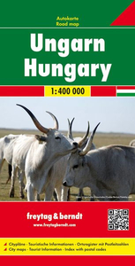
Hungary at 1:400, 000 from Freytag & Berndt, with large, easy to read print, extensive index of place names including their post codes and street plans of central Budapest and Debrecen. Road network includes small local roads and shows motorway facilities, full and limited interchanges, intermediate distances on most roads, gradients, roads closed to or not recommended for caravans, and scenic routes. Railway lines and ferry connections on the Balaton are included. The map also shows the country`s administrative divisions with names of the provinces. National parks and other protected areas are highlighted and symbols mark various places of interest, including campsites and golf courses. Topography is indicated by subtle relief shading with colouring for main forested areas. Names
of main cities are in large print and other place names are correspondingly larger than on many maps. The map has latitude and longitude lines at intervals of 30`. Map legend includes English. Extensive index is in a separate booklet attached to the map cover and gives postcodes for all locations, including places in adjoining areas of the surrounding countries. The booklet also contains street plans of central Budapest and Debrecen.
of main cities are in large print and other place names are correspondingly larger than on many maps. The map has latitude and longitude lines at intervals of 30`. Map legend includes English. Extensive index is in a separate booklet attached to the map cover and gives postcodes for all locations, including places in adjoining areas of the surrounding countries. The booklet also contains street plans of central Budapest and Debrecen.

Product Description
Reviews/Comments
Add New
Intelligent Comparison
Archived Product
Hungary Stanfords
£5.99
Archived Product

Hungary Stanfords
£9.95
Archived Product
Hungary Stanfords
£12.79
Archived Product

Hungary Stanfords
£12.79
Archived Product
Hungary Stanfords
£14.99
Archived Product
Hungary Stanfords
£12.99
Archived Product

Hungary Stanfords
£11.99
Vouchers
No voucher codes found.
Do you know a voucher code for this product or supplier? Add it to Insights for others to use.
Do you know a voucher code for this product or supplier? Add it to Insights for others to use.
 Denmark