
 United Kingdom
 France
 Germany
 Netherlands
 Sweden
 USA
USA
 Italy
Italy
 Spain
Spain
More From Contributor


Hamburg Flexi Map
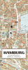
Hamburg on a laminated, tear-resistant Insight Flexi Map with an indexed street plan of the city and a road map of its environs, a diagram of the U-Bahn, S-Bahn and railway networks, plus extensive tourist information.The plan covers the city central districts, extending from the E45 motorway and the HSH Nordbank Arena in the west to Hammerbrook docks and canals in the east, and from the Elbe northwards to the Stadtpark. U-Bahn and S-Bahn lines and stations, one way streets and car parks are clearly marked. Main public buildings, places of interest and selected hotels are prominently highlighted and named. The plan is indexed for streets, districts, parks, hotels, points of interest and public buildings. Also included is a diagram of the U-Bahn, S-Bahn and railway lines.An
indexed map of the Hamburg area at 1:120, 000 covers the city
indexed map of the Hamburg area at 1:120, 000 covers the city
Product Description
Reviews/Comments
Add New
Intelligent Comparison
Archived Product
Umbria Flexi Map Stanfords
£4.99
Archived Product
Macau Flexi Map Stanfords
£4.99
Archived Product
Paris Flexi Map Stanfords
£4.99
Archived Product
Hanoi Flexi Map Stanfords
£4.99
Archived Product
Macau Flexi Map Stanfords
£5.99
Archived Product
Paris Flexi Map Stanfords
£4.99
Archived Product
Istanbul Flexi Map Stanfords
£4.99
Archived Product
Turkey Flexi Map Stanfords
£4.99
Vouchers
No voucher codes found.
Do you know a voucher code for this product or supplier? Add it to Insights for others to use.
Do you know a voucher code for this product or supplier? Add it to Insights for others to use.
 Denmark