
 United Kingdom
 France
 Germany
 Netherlands
 Sweden
 USA
USA
 Italy
Italy
 Spain
Spain
More From Contributor


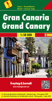
Gran Canaria
Gran Canaria at 1:75, 000 from Freytag & Berndt on a road map clearly presenting its network of main roads and various places of interest or tourist facilities, whilst also including topographic information and selected hiking routes.The map has contours with relief shading and spot heights to show the island
Product Description
Reviews/Comments
Add New
Intelligent Comparison
Archived Product
Gran Canaria Stanfords
£12.99
Archived Product
Gran Canaria Stanfords
£12.99
Archived Product
Gran Canaria Stanfords
£7.99
Archived Product

Gran Canaria Stanfords
£9.99
Archived Product
Gran Canaria F&B Stanfords
£10.99
Vouchers
No voucher codes found.
Do you know a voucher code for this product or supplier? Add it to Insights for others to use.
Do you know a voucher code for this product or supplier? Add it to Insights for others to use.
 Denmark