More From Contributor

£19.95
Florida Recreational Atlas & Gazetteer at 1:150, 000 approx. in a series of large format paperback state atlases from De Lorme, with detailed, contoured, GPS compatible topographic mapping plus extensive recreational information, with lists of sites & facilities, etc. Each title covers one state & presents it on impressively detailed mapping at scales much more detailed than used on most state road maps. Particularly popular areas are often also presented on enlargements. The maps are contoured, show variation of terrain (deserts, glaciers, wetlands, woodlands, etc) & have latitude & longitude and/or UTM grid lines for GPS use. Various types of protected areas are distinguished by the colouring of their boundaries, e.g. national or state parks, forests, etc. Also marked are Indian Reservations & restricted entry military zones. Road network is shown in much more detail than on other state mapping, with local roads, unsurfaced back roads & tracks, forest trails, etc. Where appropriate, old historical routes are marked. Railway lines & local airports or landing strips are included & the maps also indicate administrative boundaries. Symbols highlight various recreational areas & facilities such as campgrounds, unique natural features, etc. Each title contains extensive lists of outdoor adventure sites (grouped into activities such as hiking, biking, paddling, fishing, skiing, etc.), diverse family outing sites, campgrounds, & tables showing what facilities can be found in the state ...
Archived Product
£24.99
Florida Recreational Atlas & Gazetteer at 1:126, 000 approx. from De Lorme in a new edition published in 2012, with GPS compatible mapping & extensive additional recreational information including facilities at campgrounds, etc. Each title in this De Lorme series covers one state & presents it at a scale much more detailed than used on most state road maps. Particularly popular areas are often also presented on enlargements. The maps are contoured, show variation of terrain (deserts, glaciers, wetlands, woodlands, etc) & have latitude & longitude and/or UTM grid lines for GPS use. Various types of protected areas are distinguished by the colouring of their boundaries, e.g. national or state parks, forests, etc. Also marked are Indian Reservations & restricted entry military zones. Road network is shown in much more detail than on other state mapping, with local roads, unsurfaced back roads & tracks, forest trails, etc. Where appropriate, old historical routes are marked. Railway lines & local airports or landing strips are included & the maps also indicate administrative boundaries. Symbols highlight various recreational areas & facilities such as campgrounds, unique natural features, etc. Each title contains extensive lists of outdoor adventure sites (grouped into activities such as hiking, biking, paddling, fishing, skiing, etc.), diverse family outing sites, campgrounds, & tables showing what facilities can be found in the state’s recreational areas. Each atlas also has an index of localities. To see the list of titles in this series please click on the series link. ...
Archived Product
£0.00
Florida Recreational Atlas & Gazetteer at 1:126, 000 approx. from De Lorme in a new edition published in 2012, with GPS compatible mapping & extensive additional recreational information including facilities at campgrounds, etc. The atlas, part of the publishers ...
Archived Product
£11.50
Florida at 1:500, 000 in a series of waterproof & tear-resistant, indexed regional maps of USA from Reise Know-How’s highly acclaimed World Mapping Project, combining detailed presentation of the road network with topographic & tourist information. The map is double-sided to provide the best balance between detailed scale & a convenient size sheet. Coverage of the northern part of the state extends beyond Orlando & Disney World, with the panhandle shown as an inset. Maps in this series have altitude colouring with spot heights to show each region’s topography, with national parks & other protected areas, as well as American Indian Reservations & restricted entry zones clearly marked. Road network indicates toll roads & scenic routes. Driving distances are shown in miles. Railways &, where appropriate, ferry routes are marked. The maps show both names & boundaries of local counties. Symbols highlight a variety of places of interest, including historical sites, amusement parks, natural features, golf courses & wintersport areas, etc. Each map

Includes::
an index of localities & has a latitude & longitude grid (in this title at intervals of 20’). Map legend

Includes::
English. To see other titles in this series please click on the series link.


...
Archived Product
£9.99
Florida in the AA Spiral Guides series; comprising a selection of titles exploring a wide range of cities, regions & countries in a handy, spiral loose-leaf format. Fold-out flaps at the front & back of each title give an overview of the main regions covered, with page numbers so visitors can locate their destination easily. Each guide explores the destination geographically by region or area & provides the essential information for the main sites & attractions in addition to a recommended tour of each area by car. An introductory section - ...
Archived Product
£16.99
From Disney World & the Space Coast to white sand beaches & hip Miami nightlife, Florida's attractions, along with balmy weather & beautiful people, lure 82 million visitors to the state every year. Now in full color throughout, Fodor's Florida 2010 takes a smart insider's look at the state, with helpful planning advice at the start of each chapter. It
Includes::
-More than 250 color photos illustrating the beauty of Florida
-Destination overview maps & planning pages that orient you to the state's varied regions & colorful cities
-New magazine-style illustrated features highlighting Florida's top attractions & activities, from the Daytona Speedway to Kennedy Space Center to scuba diving & shelling
-An Experience Florida chapter covering what's new in the state, great itineraries, helpful tips on getting there & around, & much more to help you plan your perfect vacation
-All-new short, photo-filled features showcasing some of the state's best cuisine, Orlando's many theme parks, & abundant beaches all along the coast
-Four-color pullout map for a big-picture look at the state's geography
Fodor's. For Choice Travel Experiences.


...
Archived Product
£15.99
This guide expertly divides Florida into touring areas
- one per chapter. The best of Florida's stunning beaches & wildlife
...
Archived Product
£12.99
Florida in the National Geographic Traveler guide series, produced by America’s leading travel publishers, exploring a range of cities, regions & countries worldwide & using the expertise & tradition of National Geographic to provide a comprehensive survey of each destination. Each of the guides in the series draws upon National Geographic’s rich history of travel experience & is researched by authors familiar with the area. Whilst the content is influenced by an American editorial style, individual titles are still accessible to a non-American audience, with a combination of practical guidance & detailed information included in each guide. The series also relies upon the extensive image libraries of National Geographic to present a rich visual image of each destination. Individual National Geographic Traveler titles are organised uniformly, allowing readers to access information quickly & easily. Introductory sections provide information on Charting your Trip, with details of getting there & around & a History & Culture chapter profiling history, food & drink, land & landscape, flora & fauna & arts & literature. Chapter are arranged geographically by region, with notable cities & areas principally describing the main sites & attractions, with further information on directions, history & practicalities. There are also a number of individual features & insider tips throughout each guide covering subjects such as walking tours, local culture, driving tours, recommended local experiences & in-depth thematic short histories of the culture & histories of individual regions. A Travelwise section at the back of each guide provides essential practical information on when to go, what to take, further reading, getting there & around, local etiquette, media, holidays, money matters, religion, smoking, time differences, opening times, travellers with disabilities & accommodation. Restaurants & hotels are listed with brief descriptions & information on prices, location, contact details & facilities for the relevant regional chapters in the guide. ...
Archived Product
£13.99
Florida with southern Alabama & Georgia at 1:1, 000, 000 in a series of indexed touring road maps of USA from Hallwag, with each title conveniently covering a large region & providing enlargements of most visited areas, city maps & other useful tourist information. Enlargements cover the conurbations from Miami to West Palm Beach, Tampa/ St. Petersburg/ Sarasota/ Bradenton/ Lakeland/ Winter Haven, Orlando with Disney World & Jacksonville. The map is part of Hallwag’s series covering USA at 1:1, 000, 000. The series has been revised from its earlier version & now uses cartography from Hema which provides an excellent combination of information about the terrain, the road network & places of interest. The base map has effective but unobtrusive relief shading with plenty of names of mountain ranges, peaks (heights in feet), deserts, etc. Colouring prominently highlights national or state parks, forests & other protected areas, as well as Indian Reservations & military zones. Road network clearly shows road numbers, indicates free & toll highways with locations of services, & gives driving distances on interstate & primary routes. The maps also show Amtrak railway lines with stations, local airports, state borders & time zone boundaries. An extensive range of symbols indicate various places of tourist interest. Each map is indexed & for GPS navigation has latitude & longitude lines drawn at 30’ intervals. Each title also

Includes::
enlargements of most visited areas – please see individual descriptions for more information – & useful tourist information such as metric conversion tables, traffic signs, phone numbers/websites for many organizations including recommended accommodations, etc. Map legends & all the text include English.

...
Archived Product
£20.00
We are able to source a wide range flags in many sizes, sewn or printed on 100% Ministry Of Defence Standard Woven & Knitted Polyester. Flags are supplied with rope & toggle. If you would like more information, have a custom size request or cannot find a desired product, please email us at maritime@stanfords.co.uk. We will be glad to help! ...
Archived Product

Florida State Physical Wall Map

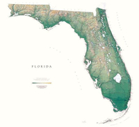
Detailed physical wall map of Florida State at a scale of 1:700, 000. The cartography shows relief through a stunning, highly detailed shading, with different elevations varing in colouring, giving an almost 3-dimensional feel to the map. Peak heights are also clearly marked.The map displays land only within the boundaries of the chosen states - there is no overlap with neigbouring states. Principal physical features such as glaciers, mountain ranges, rivers and lakes are shown clearly. Human features, such as main towns, cities, roads and railways, are shown in a very fine, subtle and elegant cartographic style. State capitals are also clearly marked.This map measures 112x122cm (44”x48”). The Florida Uplands, running through the Panhandle in the northwest, give way to the
meeting of the East Gulf and Atlantic Coastal Plains. The subtle variations in the elevation (the highest point in the state is 345ft) are shown in shades of green. The Big Cypress Swamp, The Everglades, and The Flo*About this series:*Located on the corner of Main and Central in downtown Medford, Oregon since 1986, Raven has become the quintessential small company with a big reputation. Every map is created with attention to accuracy and elegance, from gathering the base information to the final color adjustment on the printing press.
RIP - This product is no longer available on our network. It was last seen on 25.09.2019

This page now acts as a permanent archive for this product. Add more information using the comments box below to ensure it can still be found by future generations.

Use our search facility to see if it is available from an alternative contributor.
  • External links may include paid for promotion
  • Availability: Out Of Stock
  • Supplier: Stanfords
  • SKU: 9780783422718
Availability: In Stock
£30.00

Product Description

Detailed physical wall map of Florida State at a scale of 1:700, 000. The cartography shows relief through a stunning, highly detailed shading, with different elevations varing in colouring, giving an almost 3-dimensional feel to the map. Peak heights are also clearly marked. The map displays land only within the boundaries of the chosen states
- there is no overlap with neigbouring states. Principal physical features such as glaciers, mountain ranges, rivers & lakes are shown clearly. Human features, such as main towns, cities, roads & railways, are shown in a very fine, subtle & elegant cartographic style. State capitals are also clearly marked. This map measures 112x 122cm (44”x 48”). The Florida Uplands, running through the Panhandle in the northwest, give way to the meeting of the East Gulf & Atlantic Coastal Plains. The subtle variations in the elevation (the highest point in the state is 345ft) are shown in shades of green. The Big Cypress Swamp, The Everglades, & The Flo* About this series:* Located on the corner of Main & Central in downtown Medford, Oregon since 1986, Raven has become the quintessential small company with a big reputation. Every map is created with attention to accuracy & elegance, from gathering the base information to the final color adjustment on the printing press.

Reviews/Comments

Add New

Price History

Vouchers

No voucher codes found.
Do you know a voucher code for this product or supplier? Add it to Insights for others to use.

Facebook

Jargon Buster

Physical - Used to describe strength or visual properties of an item
Wall - A physical barrier between two areas
Human - A highly developed and adapted mamal and deminant species on earth
Railways - A set of tracks that have been laid for the purpose of trains to travel up and down them
running - A sport or hobbie of moving rapidly on foot. Can also refer to the running of equipment or run time refering to the length of time an applicance can run or the quiet running of an applicance.
Small - something that takes up less space than normal.
Subtle - Something that is delicate and not to harsh, can be difficult to describe.

Supplier Information

Stanfords
Stanfords was established in 1853 and opened their iconic Covent Garden flagship store in 1901. They have become the top retailer of maps, travel books and accessories in the UK and arguably offer the largest selection of maps and travel books worldwide. Famous names such as Captain Robert Falcon Scott, Ranulph Fiennes and Michael Palin have purchased from Stanfords. They now have a shop in Bristol and both stores together with other venues operate a calendar of events including talks, book signings and exhibitions. As a specialist map retailer, the map selection is comprehensive and includes road maps, street maps and walking maps from worldwide destinations, as well as a selection of world atlases and wall maps. Books include travel guides and travel literature. Stanfords also stock globes, from miniatures made of blue marble to magnificent floor-standing globes. The website features a selection of interesting articles on travel topics.
Page Updated: 2023-11-12 20:15:36

Community Generated Product Tags

Oh No! The productWIKI community hasn't generated any tags for this product yet!
Menu