
 United Kingdom
 France
 Germany
 Netherlands
 Sweden
 USA
USA
 Italy
Italy
 Spain
Spain
More From Contributor


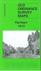


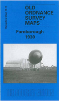
Farnborough 1930
Farnborough in 1930 in a fascinating series of reproductions of old Ordnance Survey plans in the Alan Godfrey Editions, ideal for anyone interested in the history of their neighbourhood or family. Selected towns in Great Britain and Ireland are covered by maps showing the extent of urban development in the last decades of the 19th and early 20th century.In this title: the map is double-sided. The main map covers the area from St John's church West Heath eastward to St Michael's Abbey, and from Farnborough Hill Convent School southward to Hillside College. Features include Cove, Cove Bungalows, Rafborough, Cove Green, Pinehurst Barracks, station, military line (closed 1968), North Farnborough, Forest Lodge, Tumble Down Dick Hotel. On the reverse is part of the adjacent sheet
13.14 extending coverage eastward to the county boundary. Features here include Farnborough Park, Avenue Road, Farnborough Court and the southern part of the area known as Farnborough Street. About the Alan Godfrey Editions of the 25
13.14 extending coverage eastward to the county boundary. Features here include Farnborough Park, Avenue Road, Farnborough Court and the southern part of the area known as Farnborough Street. About the Alan Godfrey Editions of the 25
Product Description
Reviews/Comments
Add New
Intelligent Comparison
Archived Product
Farnborough 1930 Stanfords
£3.50
Archived Product
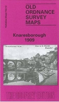
Knaresborough 1909 Stanfords
£3.50
Archived Product
Scarborough 1903-1904 Stanfords
£7.99
Archived Product
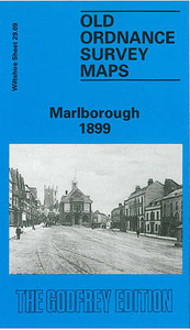
Marlborough 1899 Stanfords
£3.50
Archived Product
Masbrough 1901 Stanfords
£3.50
Archived Product

Farnworth 1908 Stanfords
£3.50
Archived Product

Greasborough 1901 Stanfords
£3.50
Archived Product
Peterborough 1901 Stanfords
£9.99
Vouchers
No voucher codes found.
Do you know a voucher code for this product or supplier? Add it to Insights for others to use.
Do you know a voucher code for this product or supplier? Add it to Insights for others to use.
 Denmark