
 United Kingdom
 France
 Germany
 Netherlands
 Sweden
 USA
USA
 Italy
Italy
 Spain
Spain
More From Contributor
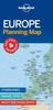


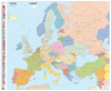
Europe Maps International Political Wall Map X-LARGE ENCAPSULATED
Extra-large 191 x 137cm paper political map of Europe from Maps International, at a scale of 1:3, 200, 000.Countries are shown in vivid colours against light blue oceans. Country names are in large, clearly legible print. English versions for capitals and most city names are used, with population information displayed on the legend; international, state and disputed boundaries are displayed.The map has well designed relief shading to show mountainous areas enhancing the overall presentation; the colouring of the oceans shows different depths. Projection is Lamberts Conformal Conic Projection.The map contains a panel of country flags in the map corner.*LAMINATED and ENCAPSULATED WALL MAPS:*- *laminated* wall maps have a thin layer of plastic usually applied to the printed side only.
They can be written on with suitable marker pens without any damage to the map but, unless laminated on both sides, they are not damp-proof.- *encapsulated* wall maps are sealed between two sheets of plastic. They are more rigid and heavier than laminated maps of the same size. They are damp-proof and do not crinkle in humid conditions. Encapsulation gives the map a shiny surface, similar to being displayed behind glass.- *please note:* many publishers and retailers often use these two terms interchangeably. Our map titles and descriptions follow the definitions provided above.
They can be written on with suitable marker pens without any damage to the map but, unless laminated on both sides, they are not damp-proof.- *encapsulated* wall maps are sealed between two sheets of plastic. They are more rigid and heavier than laminated maps of the same size. They are damp-proof and do not crinkle in humid conditions. Encapsulation gives the map a shiny surface, similar to being displayed behind glass.- *please note:* many publishers and retailers often use these two terms interchangeably. Our map titles and descriptions follow the definitions provided above.
Product Description
Reviews/Comments
Add New
Intelligent Comparison
Archived Product
Europe Maps International Political Wall Map LARGE ENCAPSULATED Stanfords
£28.99
Archived Product

Europe Maps International Political Wall Map X-LARGE PAPER Stanfords
£28.99
Archived Product

Africa Maps International Political Wall Map ENCAPSULATED Stanfords
£28.99
Archived Product

Asia: Maps International Political Wall Map ENCAPSULATED Stanfords
£28.99
Archived Product
World Maps International Political Wall Map X-LARGE PAPER Stanfords
£30.99
Archived Product

Europe Maps International Political Wall Map PAPER LARGE Stanfords
£19.99
Archived Product

South America Maps International Political Wall Map ENCAPSULATED Stanfords
£28.99
Archived Product

Europe: Maps International Political Wall Map LARGE, HANGING STRIPS Stanfords
£35.99
Vouchers
No voucher codes found.
Do you know a voucher code for this product or supplier? Add it to Insights for others to use.
Do you know a voucher code for this product or supplier? Add it to Insights for others to use.
 Denmark