More From Contributor

£3.99
Edinburgh Atlas & Guide is a pocket-sized, indexed street atlas at 1:12, 000 from Collins. Shows the central areas with large amounts of tourist information & enlarged plans of the Royal Mile & Edinburgh Castle. Main roads (with road numbers) & streets are shown with an indication of one-way streets & car parks. Train stations, railway lines & some footpaths (e.g. the Water of Leith Walkway) are displayed. Many sites & buildings of interest to the tourist are indicated (such as theatres, major hotels & tourist information offices), as are post offices, libraries, places of worship & many public & commercial buildings. Parks & woodland are also displayed. The map covers central Edinburgh & some of the inner residential areas. See adjoining image for full coverage. Also
Includes:: Around 45 pages of tourist information (with map references), giving prices, facilities, opening times, contact details & background information. Also

Includes::
information about transport, accommodation, eating, drinking, entertainment & shopping. An enlarged map of the area around the Royal Mile at 1:9, 000, with greater detail of streets & places of interest. A plan of Edinburgh Castle, with tourist information. A plan of Edinburgh Airport at 1:12, 000.


...
Archived Product
£3.50
Edinburgh`s Calton Hill area in 1877 in a series of exceptionally detailed reproductions of old Ordnance Survey street plans for areas of larger cities which have undergone substantial redevelopment in the late 19th or the early 20th century, published in the Alan Godfrey Editions. The plans, printed in back & white, have been taken from the original Ordnance Survey mapping at 1:1, 056 & reproduced at 1:1, 760 – the equivalent of 36 inches (or one yard) to a mile. The maps provide an unrivalled, house-by-house picture of streets & individual buildings with inner courtyards, outbuildings, pavements, covered passages, etc. Many important institutions are named; within the National Galley on Trafalgar Square even the individual rooms (the map is from 1871, so no French Impressionists as yet!). On the reverse are historical notes about the area covered by the map, plus extracts from contemporary street directories. These maps provide a fascinating addition to Alan Godfrey’s huge series of some 2, 000 titles presenting reproductions of street plans at taken from the Ordnance Survey mapping at 1:2, 500 (25” to 1 mile) & reprinted at about 15 inches to one mile (1:4, 340). ...
Archived Product
£3.50
Edinburgh Castle area in 1877 in a series of exceptionally detailed reproductions of old Ordnance Survey street plans for areas of larger cities which have undergone substantial redevelopment in the late 19th or the early 20th century, published in the Alan Godfrey Editions. The plans, printed in back & white, have been taken from the original Ordnance Survey mapping at 1:1, 056 & reproduced at 1:1, 760 – the equivalent of 36 inches (or one yard) to a mile. The maps provide an unrivalled, house-by-house picture of streets & individual buildings with inner courtyards, outbuildings, pavements, covered passages, etc. Many important institutions are named; within the National Galley on Trafalgar Square even the individual rooms (the map is from 1871, so no French Impressionists as yet!). On the reverse are historical notes about the area covered by the map, plus extracts from contemporary street directories. These maps provide a fascinating addition to Alan Godfrey’s huge series of some 2, 000 titles presenting reproductions of street plans at taken from the Ordnance Survey mapping at 1:2, 500 (25” to 1 mile) & reprinted at about 15 inches to one mile (1:4, 340). ...
Archived Product
£3.50
Central Edinburgh in 1894 in a fascinating series of reproductions of old Ordnance Survey plans in the Alan Godfrey Editions, ideal for anyone interested in the history of their neighbourhood or family. Coverage extends from Waverley Bridge westwards to Belford Road & from Lauriston Place northward to Cumberland Street. Features include St Giles Cathedral, The Castle, Princes Street station, western end of Waverley station, Haymarket station, most of Princes Street, most of the New Town around George Street, National Gallery, Grassmarket, Charlotte Square, Belgrave Crescent Gardens, Donaldson`s Hospital, Ravelston area, Daniel Stewart`s College, Coates area, Moray Place, St Andrew Square, National Portrait Gallery, tramways, Royal Infirmary, St George`s church, Queen Street Gardens, etc. On the reverse are street directory entries for Princes Street, Queen Street & Queensferry Street. Please note: this reprint was originally published as Edinburgh (Princes St) 1896. About the Alan Godfrey Editions of the 25” OS Series: Selected towns in Great Britain & Ireland are covered by maps showing the extent of urban development in the last decades of the 19th & early 20th century. The plans have been taken from the Ordnance Survey mapping & reprinted at about 15 inches to one mile (1:4, 340). On the reverse most maps have historical notes & many also include extracts from contemporary directories. Most maps cover about one mile (1.6kms) north/south, one & a half miles (2.4kms) across; adjoining sheets can be combined to provide wider coverage.FOR MORE INFORMATION & A COMPLETE LIST OF ALL AVAILABLE TITLES PLEASE CLICK ON THE SERIES LINK. ...
Archived Product
£4.99
AA City Map Edinburgh is extremely useful & easy-to-use. One side contains a map of Edinburgh, with places of interest marked on. The reverse side contains comprehensive tourist & transport information, all to help you find your way around while not missing out on the best sights. The map is laminated, making it weatherproof & perfect for when you are out & about. Tourist information

Includes::
the top 25 sights, shopping, where to eat & drink, ticketing information, a transport map & how to get around.

...
Archived Product
£7.99
In this new edition, the Top 25 sights & experiences are now in one section. We`ve selected the must-see sights for you & put them in one place
- all you have to do is take your pick. If you want a bit more guidance, go to the new City Tours section, self-guided tours that bring you the best of the city. Or if you have extra time on your hands, turn to the More to See sights. Our new feature, Focus On, helps you to get to know the city in more depth. & we still include top tips on how to make the most of your trip, as well as great places to shop, eat, drink & sleep for every budget. But it`s not just a guidebook. As you would expect from the AA, your City Pack also comes with a weather-resistant map that has all the sights located on it. The map has even got its own wallet in the back so you can fold away for safe-keeping.
...
Archived Product
£7.99
We`ve selected the top 25 sights & experiences so you can be sure that you won`t miss the best of them. There are also recommendations for fantastic shops, restaurants, hotels, activities & entertainment venues. & because time is so important, we`ve given a planned itinerary for a short stay to get the best out of the destination. The guide is small enough to fit into your pocket yet it is filled with practical information, hints & tips. A durable, fold-out map of the destination is also included, so finding your way will be easy. ...
Archived Product
£5.99
This is the savvy city breakers' pocket guide to seeing & doing more in Edinburgh
- with a fun-seeking & cost-conscious slant.
...
Archived Product
£9.99
Are you wondering what to do in Edinburgh? Whether you`re a first-time visitor or visit Edinburgh regularly, City Walks Edinburgh provides a new look at this historic city with original walks & insightful stories. Discover the best things to do in Edinburgh from the Edinburgh dungeons to Edinburgh Castle. Walk through one of the most interesting cities in the world & watch Edinburgh come to life, from Bruntsfield to Royal Mile, expert guide Margot Mc Murdo gives you a personal Edinburgh tour, with each walk packed full of intriguing tales & unique features including, Calton Hill, New Town, Edinburgh castles & Arthur`s Seat. Learn little known facts & stories in a fun & exciting way, & discover the events that shaped Edinburgh into the vibrant city it is today. Take this handy guide with you as you travel around & explore the off route detours to find out Edinburgh`s deeper secrets or link two or more routes to create your own unique day out. Be guided to the most famous areas & lesser known corners of Edinburgh with City Walks, including: -15 short walks in Edinburgh
- Dozens of intriguing tales & fascinating history told in each walk
- Simple route description & easy-to-follow maps
- Key features & viewpoints for each walk
- Walk statistics including distance & estimated time
- Accompanying colour photographs
- Recommended refreshment stops Your own personal walking tour of Edinburgh.


...
Archived Product
£2.99
Handy little full colour Collins map of central Edinburgh with a high level of detail. Clear mapping from Leith in the north to The Meadows in the south, & Edinburgh Zoo in the west to Holyrood Park in the east. Map at a scale of 1:11, 000 (6 inches to 1 mile). Clear, detailed, full colour Collins mapping is presented in a handy format ideal for the pocket or handbag. It is excellent value & covers the most visited area of central Edinburgh. It is an essential buy for tourists & residents alike.
Includes:* Detailed central area map* Around Edinburgh map extending to airport, Pentland Hills & Forth Road Bridge* Tourist locations* Tram, Train & bus stations* Listing of major places to visit, with additional details for Edinburgh Castle & Holyroodhouse* Detailed street index
...
Archived Product

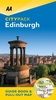
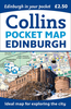
Edinburgh City Pack Guide

Edinburgh in the City Pack series from AA Publishing; covering an extensive selection of world-wide cities in a handy, pocket-sized laminated format. The guides provde a detailed overview of each destination, with each city organised by district to allow for practical use on the city streets. An introductory section introduces readers to the city, with individual features on a short stay in the city, the Top 25 attractions, shopping by theme, the city by night, eating out and restaurants by cuisine.Each guide is presented in a similar format, exploring the city by geographical area and district. A basic overview map is provided at the start of each section and there is detailed listings information on the principal sights, walks, shops, entertainment and nightlife and
restaurants for each area of the city. A Farther Afield section explores the area outside the city limits, with suggestions for possible excursions and day trips. A dedicated accommodation chapter provides information about a range of budget, mid-range and luxury hotels to suit for individual tastes. There is also a Need to Know chapter with practical information on getting there and around, essential facts, language and a timeline of the city.
RIP - This product is no longer available on our network. It was last seen on 25.09.2019

This page now acts as a permanent archive for this product. Add more information using the comments box below to ensure it can still be found by future generations.

Use our search facility to see if it is available from an alternative contributor.
  • Availability: Out Of Stock
  • Supplier: Stanfords
  • SKU: 9780749554897
Availability: In Stock
£6.99

Product Description

Edinburgh in the City Pack series from AA Publishing; covering an extensive selection of world-wide cities in a handy, pocket-sized laminated format. The guides provde a detailed overview of each destination, with each city organised by district to allow for practical use on the city streets. An introductory section introduces readers to the city, with individual features on a short stay in the city, the Top 25 attractions, shopping by theme, the city by night, eating out & restaurants by cuisine. Each guide is presented in a similar format, exploring the city by geographical area & district. A basic overview map is provided at the start of each section & there is detailed listings information on the principal sights, walks, shops, entertainment & nightlife & restaurants for each area of the city. A Farther Afield section explores the area outside the city limits, with suggestions for possible excursions & day trips. A dedicated accommodation chapter provides information about a range of budget, mid-range & luxury hotels to suit for individual tastes. There is also a Need to Know chapter with practical information on getting there & around, essential facts, language & a timeline of the city.

Reviews/Comments

Add New

Price History

Vouchers

No voucher codes found.
Do you know a voucher code for this product or supplier? Add it to Insights for others to use.

Facebook

Jargon Buster

Edinburgh - The capital city of Scotland
World - A physical grouping, commonly used to describe earth and everything associated with ti
Entertainment - Something that provides amusement
Day - The time it takes a planet or other space objects to complete one rotation.
Language - the method of communication used in different areas. Humans and computers have many different languages.
Wide - Something with a large width.
Luxury - An exquisite way of living, an sometimes come at a higher price.
Accommodation - A room in which someone can live in, for example in a hotel
Practical - Weather a task is easy to carry out and realistically succeed.
Pocket - A bag shaped insert in clothing used to carry items
Laminated - A thin layer of plastic that gives a coating and shine to a material.
Individual - A single separate item or person.
Language - The way humans communicate either written and spoken.

Supplier Information

Stanfords
Stanfords was established in 1853 and opened their iconic Covent Garden flagship store in 1901. They have become the top retailer of maps, travel books and accessories in the UK and arguably offer the largest selection of maps and travel books worldwide. Famous names such as Captain Robert Falcon Scott, Ranulph Fiennes and Michael Palin have purchased from Stanfords. They now have a shop in Bristol and both stores together with other venues operate a calendar of events including talks, book signings and exhibitions. As a specialist map retailer, the map selection is comprehensive and includes road maps, street maps and walking maps from worldwide destinations, as well as a selection of world atlases and wall maps. Books include travel guides and travel literature. Stanfords also stock globes, from miniatures made of blue marble to magnificent floor-standing globes. The website features a selection of interesting articles on travel topics.
Page Updated: 2023-11-12 20:15:36

Community Generated Product Tags

Oh No! The productWIKI community hasn't generated any tags for this product yet!
Menu