
 United Kingdom
 France
 Germany
 Netherlands
 Sweden
 USA
USA
 Italy
Italy
 Spain
Spain
More From Contributor


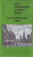
Edinburgh Central 1894
Central Edinburgh in 1894 in a fascinating series of reproductions of old Ordnance Survey plans in the Alan Godfrey Editions, ideal for anyone interested in the history of their neighbourhood or family. Coverage extends from Waverley Bridge westwards to Belford Road and from Lauriston Place northward to Cumberland Street. Features include St Giles Cathedral, The Castle, Princes Street station, western end of Waverley station, Haymarket station, most of Princes Street, most of the New Town around George Street, National Gallery, Grassmarket, Charlotte Square, Belgrave Crescent Gardens, Donaldson`s Hospital, Ravelston area, Daniel Stewart`s College, Coates area, Moray Place, St Andrew Square, National Portrait Gallery, tramways, Royal Infirmary, St George`s church,
Queen Street Gardens, etc. On the reverse are street directory entries for Princes Street, Queen Street and Queensferry Street. Please note: this reprint was originally published as Edinburgh (Princes St) 1896.About the Alan Godfrey Editions of the 25” OS Series:Selected towns in Great Britain and Ireland are covered by maps showing the extent of urban development in the last decades of the 19th and early 20th century. The plans have been taken from the Ordnance Survey mapping and reprinted at about 15 inches to one mile (1:4, 340). On the reverse most maps have historical notes and many also include extracts from contemporary directories. Most maps cover about one mile (1.6kms) north/south, one and a half miles (2.4kms) across; adjoining sheets can be combined to provide wider
coverage.FOR MORE INFORMATION AND A COMPLETE LIST OF ALL AVAILABLE TITLES PLEASE CLICK ON THE SERIES LINK.

Product Description
Reviews/Comments
Add New
Vouchers
No voucher codes found.
Do you know a voucher code for this product or supplier? Add it to Insights for others to use.
Do you know a voucher code for this product or supplier? Add it to Insights for others to use.
 Denmark