
 United Kingdom
 France
 Germany
 Netherlands
 Sweden
 USA
USA
 Italy
Italy
 Spain
Spain
More From Contributor


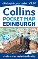
Edinburgh Collins Pocket Map
Handy little full colour Collins map of central Edinburgh with a high level of detail. Clear mapping from Leith in the north to The Meadows in the south, and Edinburgh Zoo in the west to Holyrood Park in the east. Map at a scale of 1:11, 000 (6 inches to 1 mile).Clear, detailed, full colour Collins mapping is presented in a handy format ideal for the pocket or handbag. It is excellent value and covers the most visited area of central Edinburgh. It is an essential buy for tourists and residents alike.INCLUDES* Detailed central area map* Around Edinburgh map extending to airport, Pentland Hills and Forth Road Bridge* Tourist locations* Tram, Train and bus stations* Listing of major places to visit, with additional details for Edinburgh Castle and Holyroodhouse* Detailed street index

Product Description
Reviews/Comments
Add New
Vouchers
No voucher codes found.
Do you know a voucher code for this product or supplier? Add it to Insights for others to use.
Do you know a voucher code for this product or supplier? Add it to Insights for others to use.
 Denmark