
 United Kingdom
 France
 Germany
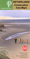
 Netherlands
 Sweden
 USA
USA
 Italy
Italy
 Spain
Spain
More From Contributor


Easter Island
Physical map of the Easter Island (Rapa Nui) with the relief represented by contours at 10m intervals, spot heights and elevation colouring. Main unpaved roads, tracks, and footpaths are clearly marked, with distances and/or journey times on foot, by bike or on horseback shown for most routes. Landmarks such as the famous moai statues, ceremonial platforms, and caves are highlighted. Further information of interest to visitors include campsites, ranger stations, gas stations, beaches, rock art sites, etc. Latitude and longitude margin ticks are at 1' intervals. Map legend is in Spanish and English. A small inset shows the streets of central Hanga Roa at a slightly enlarged scale.The whole of the reverse side it taken by bilingual notes on the island and its history, art,
fauna and flora, with photos, drawings and a panorama view naming various hills. Please note: deliveries of JLM maps are very irregular
fauna and flora, with photos, drawings and a panorama view naming various hills. Please note: deliveries of JLM maps are very irregular
Product Description
Reviews/Comments
Add New
Intelligent Comparison
Archived Product
Easter Island Stanfords
£9.95
Archived Product
Easter Island Stanfords
£19.95
Archived Product
Fraser Island Stanfords
£8.95
Archived Product
Fraser Island Stanfords
£8.99
Archived Product
Chile & Easter Island Stanfords
£15.99
Archived Product
Chile & Easter Island Stanfords
£15.99
Archived Product
Gaasterland Stanfords
£8.99
Archived Product
Chile And Easter Island Stanfords
£12.79
Vouchers
No voucher codes found.
Do you know a voucher code for this product or supplier? Add it to Insights for others to use.
Do you know a voucher code for this product or supplier? Add it to Insights for others to use.
 Denmark