More From Contributor

£9.09
Map No. 199, Eatsbourne & Hastings, in the waterproof & tear-resistant OS Active version of the Ordnance Survey Landranger series at 1:50, 000, including Crowborough, Battle, Heathfield, Bexhill, Wadhurst, Hawkhurst, Hailsham, Benenden, Sandhurst, Northiam, Peasmarsh, Broad Oak, Icklesham, Fairlight Cove, Westfield, Crowhurst, Netherfield, Staplecross, Robetrsbridge, Hurst Green, Ticehurst, Stonegate, Dallington, Catsfield, Herstmonceux, Hooe, Pevensey Bay, Polegate, East Dean, Alfriston, Lower Dicker, Cowbeech, Laughton, East Hoathly, Buxted, Hadlow Down, Mayfield, Broad Oak, Burwash, Rotherfield, Horam, Bewl Water Reservoir, Pevensey Levels, Beachy Head, & the easternmost section of the South Downs Way. Edition D3 with minor changes; Publication date April 2012 About Ordnance Survey ...
Archived Product
£10.39
Map No. 199, Eatsbourne & Hastings, in a waterproof & tear-resistant version of the Ordnance Survey Landranger series at 1:50, 000, including Crowborough, Battle, Heathfield, Bexhill, Wadhurst, Hawkhurst, Hailsham, Benenden, Sandhurst, Northiam, Peasmarsh, Broad Oak, Icklesham, Fairlight Cove, Westfield, Crowhurst, Netherfield, Staplecross, Robetrsbridge, Hurst Green, Ticehurst, Stonegate, Dallington, Catsfield, Herstmonceux, Hooe, Pevensey Bay, Polegate, East Dean, Alfriston, Lower Dicker, Cowbeech, Laughton, East Hoathly, Buxted, Hadlow Down, Mayfield, Broad Oak, Burwash, Rotherfield, Horam, Bewl Water Reservoir, Pevensey Levels & Beachy Head. Edition D3; Revised 1999; Revised for selected changes 2001, 2003, 2008; Copyright date 2009 This title is also available on our website in a waterproof & tear-resistant version. Maps in this series are only published folded. Stanfords can also print flat versions of Ordnance Survey maps through the OS Select system, centring the map on a location of your choice & with a picture provided by you on the cover. For more information please click on the link at the bottom of this description. About Ordnance Survey ...
Archived Product
£14.99
Eastbourne & Hastings area, including the Seven Sisters & sections of the South Downs Way & the E9 European Long-distance Path, on a waterproof & tear-resistant OS Active version of map No. 199 from the Ordnance Survey’s Landranger series at 1:50, 000, with contoured & GPS compatible topographic mapping plus tourist information.MOBILE DOWNLOADS: As well as the physical edition of the map, each Landranger title now

Includes::
a code for downloading after purchase its digital version onto your smartphone or tablet for viewing on the OS smartphone app.OS LANDRANGER SERIES: to see the list of all the titles in the OS Landranger series, both paper & waterproof versions, please click on the series link. Maps in the Landranger series provide plenty of recreational & tourist information, indicating the traditional public right of way paths (except in Scotland where different laws apply), including bridleways & byways restricted or open to motorized traffic. National Trails & selected other long-distance paths are marked, as well as on-road & traffic-free cycle routes with their National/ Regional Cycle Network numbers. National Trust/ National Trust for Scotland & Forestry Commission land is clearly marked, indicating open or restricted access. A range of symbols highlights camping & caravanning sites, youth hostels, tourist information offices & visitors’ centres, parking & picnicking places, World Heritage sites, sport & recreational facilities, etc. The maps provide detailed presentation of topography with contours at 10m intervals, numerous spot heights & additional colouring and/or graphics for different types of woodlands, orchards or parkl&, rock features including scree & cliffs, water features inland & along the sea shore with marshl&, dunes, s&, mud, shingle & the high water mark. All the standard information expected of survey mapping at this scale is included: finely graded road network, railway lines with stations, cuttings, embankments, etc; individual isolated buildings; archaeological & historical sites, etc. For GPS users the British National Grid is shown at 1km intervals, with latitude & longitude given by margin ticks at 1` & cross hairs on the map at 5`. Each map covers an area of 40 x 40km, (approx. 25 x 25 miles).

...
Archived Product
£8.99
Eastbourne & Hastings area, including the Seven Sisters & sections of the South Downs Way & the E9 European Long-distance Path, on a paper version of map No. 199 from the Ordnance Survey’s Landranger series at 1:50, 000, with contoured & GPS compatible topographic mapping plus tourist information.MOBILE DOWNLOADS: As well as the physical edition of the map, each Landranger title now

Includes::
a code for downloading after purchase its digital version onto your smartphone or tablet for viewing on the OS smartphone app.OS LANDRANGER SERIES: to see the list of all the titles in the OS Landranger series, both paper & waterproof versions, please click on the series link. Maps in the Landranger series provide plenty of recreational & tourist information, indicating the traditional public right of way paths (except in Scotland where different laws apply), including bridleways & byways restricted or open to motorized traffic. National Trails & selected other long-distance paths are marked, as well as on-road & traffic-free cycle routes with their National/ Regional Cycle Network numbers. National Trust/ National Trust for Scotland & Forestry Commission land is clearly marked, indicating open or restricted access. A range of symbols highlights camping & caravanning sites, youth hostels, tourist information offices & visitors’ centres, parking & picnicking places, World Heritage sites, sport & recreational facilities, etc. The maps provide detailed presentation of topography with contours at 10m intervals, numerous spot heights & additional colouring and/or graphics for different types of woodlands, orchards or parkl&, rock features including scree & cliffs, water features inland & along the sea shore with marshl&, dunes, s&, mud, shingle & the high water mark. All the standard information expected of survey mapping at this scale is included: finely graded road network, railway lines with stations, cuttings, embankments, etc; individual isolated buildings; archaeological & historical sites, etc. For GPS users the British National Grid is shown at 1km intervals, with latitude & longitude given by margin ticks at 1` & cross hairs on the map at 5`. Each map covers an area of 40 x 40km, (approx. 25 x 25 miles).

...
Archived Product
£4.99
A perfect activity book for Easter; little children will love adding stickers to the lively scenes & bringing them to life. This title features fun, Easter-themed scenes with lively illustrations. Including over 150 colourful stickers to decorate the pages, it presents lively scenes such as: Easter baking, hunting for eggs, Easter bonnets, a tea party & an Easter parade. ...
Archived Product
£5.99
This is a charming Easter book with a counting element for little children, with one big colourful easter egg to find under a flap on each spread. Children will enjoy helping each group of baby animals to find the egg that the Easter Bunny has hidden for them
- lambs, ducklings, chicks, puppies & kittens. At the end of the book there`s a chance to count all five eggs, & to find the elusive easter bunny under a flap. The scenes include: lambs in a meadow, ducklings on a pond, hens & chicks in the farmyard, puppies in the garden & kittens in the barn.
...
Archived Product
£8.99
Peter Rabbit & his friends love Easter, & this year the race is on to find as many Easter eggs as possible. There are lots of fun flaps to lift & pops to discover in this playful eggstravaganza! Children can lift the giant flaps to reveal Peter Rabbit`s burrow, then help Peter to pull up some radishes & turnips before Mr. Mc Gregor catches him! Next they can help Jemima Puddle-duck to find her naughty little ducklings, & join Peter & his friends to find the ten hidden Easter eggs! Make sure they look out for the amazing pop-up surprise! Peter Rabbit Easter Egg Hunt is the perfect Easter gift, & is ideal for parents to enjoy with their children. It will appeal to Peter Rabbit fans & any children who enjoy animal stories. ...
Archived Product
£4.99
This is a delightful activity book specially designed for sharing with young children. Activities include printed chicks, Easter egg tags, finger-printed tree blossoms & lots of ideas for drawing & painting, finger painting, & cutting & sticking. As well as being fun, the activities will help to develop important skills such as hand control, coordination & concentration. ...
Archived Product
£9.95
Topographic road map with relief showed by 20m contours, elevation tinting & spot heights for selected peaks. Main roads, secondary roads, tracks & airports are shown. Symbols denote statues, topknots, craters & other landmarks & points of interest, also accommodation, post offices & hosptals. Latitude & longitude margin ticks at 5' intervals. Annotated with geographical & historical information. ...
Archived Product
£13.95
Physical map of the Easter Island (Rapa Nui) with the relief represented by contours at 10m intervals, spot heights & elevation colouring. Main unpaved roads, tracks, & footpaths are clearly marked, with distances and/or journey times on foot, by bike or on horseback shown for most routes. Landmarks such as the famous moai statues, ceremonial platforms, & caves are highlighted. Further information of interest to visitors include campsites, ranger stations, gas stations, beaches, rock art sites, etc. Latitude & longitude margin ticks are at 1' intervals. Map legend is in Spanish & English. A small inset shows the streets of central Hanga Roa at a slightly enlarged scale. The whole of the reverse side it taken by bilingual notes on the island & its history, art, fauna & flora, with photos, drawings & a panorama view naming various hills. Please note: deliveries of JLM maps are very irregular ...
Archived Product

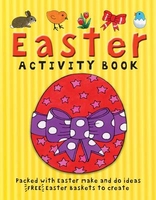
Easter Activity Book

Packed with good, simple craft ideas for children to celebrate springInside this book are excellent craft activities with step-by-step instructions, including ones for painting eggs for gifts and decorations, and creating paper flowers to brighten up your home. Learn about sprouting seeds for a fresh, tasty salad, and make mouth-watering marzipan animals. Mixed in are extra puzzles and fun games to play. Blow away those winter blues and make Easter full of fun for all the family!
RIP - This product is no longer available on our network. It was last seen on 25.09.2019

This page now acts as a permanent archive for this product. Add more information using the comments box below to ensure it can still be found by future generations.

Use our search facility to see if it is available from an alternative contributor.
  • External links may include paid for promotion
  • Availability: Out Of Stock
  • Supplier: Stanfords
  • SKU: 9781874735465
Availability: In Stock
£4.99

Product Description

Packed with good, simple craft ideas for children to celebrate spring Inside this book are excellent craft activities with step-by-step instructions, including ones for painting eggs for gifts & decorations, & creating paper flowers to brighten up your home. Learn about sprouting seeds for a fresh, tasty salad, & make mouth-watering marzipan animals. Mixed in are extra puzzles & fun games to play. Blow away those winter blues & make Easter full of fun for all the family!

Reviews/Comments

Add New

Intelligent Comparison

Oooops!
We couldn't find anything!
Perhaps this product's unique.... Or perhaps we are still looking for comparisons!
Click to bump this page and we'll hurry up.

Price History

Vouchers

No voucher codes found.
Do you know a voucher code for this product or supplier? Add it to Insights for others to use.

Facebook

Jargon Buster

Paper - A thin sheet mainly used for writing. Available in a variety of colours. Made mainly from wood pulp.
Seeds - A small embryonic plant within a casing. Used to grow plants
Fun - Something that provides amusement or enterainment
Simple - Basic, easy no difficulty in understanding.
Home - A place of permanent residence for families.
Instructions - An informative direction to take.
Winter - The fourth season of a year that comes between Spring and Autumn
Children - A young life form within the early stages of physical development,
Family - A group of people that live together made up from parents and children.

Supplier Information

Stanfords
Stanfords was established in 1853 and opened their iconic Covent Garden flagship store in 1901. They have become the top retailer of maps, travel books and accessories in the UK and arguably offer the largest selection of maps and travel books worldwide. Famous names such as Captain Robert Falcon Scott, Ranulph Fiennes and Michael Palin have purchased from Stanfords. They now have a shop in Bristol and both stores together with other venues operate a calendar of events including talks, book signings and exhibitions. As a specialist map retailer, the map selection is comprehensive and includes road maps, street maps and walking maps from worldwide destinations, as well as a selection of world atlases and wall maps. Books include travel guides and travel literature. Stanfords also stock globes, from miniatures made of blue marble to magnificent floor-standing globes. The website features a selection of interesting articles on travel topics.
Page Updated: 2023-11-12 20:15:36

Community Generated Product Tags

Oh No! The productWIKI community hasn't generated any tags for this product yet!
Menu