
 United Kingdom
 France
 Germany
 Netherlands
 Sweden
 USA
USA
 Italy
Italy
 Spain
Spain
More From Contributor


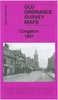


Congleton 1897
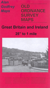
Congleton in 1897 in a fascinating series of reproductions of old Ordnance Survey plans in the Alan Godfrey Editions, ideal for anyone interested in the history of their neighbourhood or family. Selected towns in Great Britain and Ireland are covered by maps showing the extent of urban development in the last decades of the 19th and early 20th century.In this title: the map covers most of the town of Congleton, together with the village of Buglawton. Features include town centre with individual buildings neatly shown, Buglawton, Biddulph Valley Branch to Buglawton, small section of North Staffordshire Railway but not Congleton station, Bath Vale, Hardings Bank, River Dane, Lower Heath, St Peter's church, Moody Hall, Victoria Mill, silk mills, St Stephen's church, Vale Mill
etc. A list of private residents from an 1898 directory is on the reverse. About the Alan Godfrey Editions of the 25
etc. A list of private residents from an 1898 directory is on the reverse. About the Alan Godfrey Editions of the 25
Product Description
Reviews/Comments
Add New
Intelligent Comparison
Archived Product

Congleton 1897 Stanfords
£3.50
Archived Product
Colinton 1893 Stanfords
£3.50
Vouchers
No voucher codes found.
Do you know a voucher code for this product or supplier? Add it to Insights for others to use.
Do you know a voucher code for this product or supplier? Add it to Insights for others to use.
 Denmark