
 United Kingdom
 France
 Germany
 Netherlands
 Sweden
 USA
USA
 Italy
Italy
 Spain
Spain
More From Contributor


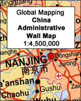
China Administrative Gizi Map
An administrative map of China at 1:6, 500, 000 from Gizi Map showing the division of the country into provinces. All place names are given in both Chinese and Latin alphabet. Hong Kong and the Pearl River Delta are presented in a greater detail on an inset. China’s provinces are shown in bright contrasting colours. Town symbols indicate the size of the population. Main airports and ports are marked, as well as coastal and international shipping routes, Topographic information is limited to the network of rivers. Latitude and longitude lines are at 5° intervals. The map is not indexed. Multilingual map legend includes English. An inset shows Hong Kong and the Pearl River Delta region at 1:1, 000, 000.* This title is also available as a wall map.
Product Description
Reviews/Comments
Add New
Intelligent Comparison
Archived Product
China Administrative Wall Map Stanfords
£13.50
Archived Product
China Administrative Wall Map Stanfords
£9.99
Archived Product
Rwanda Administrative Map Stanfords
£9.50
Archived Product
Iran Administrative Map Stanfords
£33.95
Archived Product
Spain Administrative Wall Map Stanfords
£9.99
Archived Product
China Central Gizi Map Stanfords
£9.99
Archived Product
France Administrative Map Stanfords
£5.50
Archived Product
France Administrative Map Stanfords
£5.50
Vouchers
No voucher codes found.
Do you know a voucher code for this product or supplier? Add it to Insights for others to use.
Do you know a voucher code for this product or supplier? Add it to Insights for others to use.
 Denmark