
 United Kingdom
 France
 Germany
 Netherlands
 Sweden
 USA
USA
 Italy
Italy
 Spain
Spain
More From Contributor


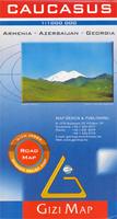
Caucasus (Road Edition)
The Caucasus at 1:1, 000, 000 from Gizi Map, presenting the region in a road edition with relief shading to show its topography and make the road network stand out better against the background. Coverage includes the southern republics of Russia. International boundaries are clearly marked. Within Georgia the map indicates the boundaries of South Ossetia, Abkhazia and Adjara; in Azerbaijan the border of Nagorno Karabach and the ceasefire line are marked. Coverage within Russia extends north of Krasnodar and Stavropol, with boundaries of individual republics including Chechnya, North Ossetia and Dagestan. Place names are shown in Latin alphabet, but within Georgia, Armenia and Russia larger towns are also named in local script.Relief shading with plenty of names of geographical
features such as individual mountain ranges, peaks, swamps, salt flats, etc, presents the topography. Road network is graded in six types, with driving distances on main and selected connecting routes. Railway lines are included and local airports are marked. Symbols highlight various places of interest. Latitude and longitude lines are drawn at 1° intervals. The index, arranged by country, is on the reverse. Multilingual map legend includes English.A separate insets presents at-a-glance the political and administrative division of the region.PLEASE NOTE: this map is also available as a wall map, plus the same cartography but with altitude colouring to emphasize the topography is also used in Gizi Map’s geographical edition of this title, also available folded or flat.
features such as individual mountain ranges, peaks, swamps, salt flats, etc, presents the topography. Road network is graded in six types, with driving distances on main and selected connecting routes. Railway lines are included and local airports are marked. Symbols highlight various places of interest. Latitude and longitude lines are drawn at 1° intervals. The index, arranged by country, is on the reverse. Multilingual map legend includes English.A separate insets presents at-a-glance the political and administrative division of the region.PLEASE NOTE: this map is also available as a wall map, plus the same cartography but with altitude colouring to emphasize the topography is also used in Gizi Map’s geographical edition of this title, also available folded or flat.
 "Pin It")
Product Description
Reviews/Comments
Add New
Vouchers
No voucher codes found.
Do you know a voucher code for this product or supplier? Add it to Insights for others to use.
Do you know a voucher code for this product or supplier? Add it to Insights for others to use.
 Denmark