
 United Kingdom
 France
 Germany
 Netherlands
 Sweden
 USA
USA
 Italy
Italy
 Spain
Spain
More From Contributor


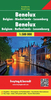


Benelux Road Atlas
Benelux Road Atlas from Insight, indexed and at a scale of 1:300, 000 is designed for motorists in Belgium, Netherlands and Luxemburg. In addition to the main countries wide road mapping, the atlas has 13 indexed Benelux city plans, 7 general European overview maps and a route planning road map of Europe at a scale of 1:4, 000, 000. Distance indicators and motorway junction numbers are given for major routes through the three countries, with filling stations, motels and road side restaurants marked. Motorways, dual carriageways, trunk roads, main and secondary roads are shown, as are airports, ferries and major railway lines. City plan road maps also indicate pedestrian zones, rail lines, central stations, bus stations and parking facilities, as well as places of interest
for the visitor, tourist attractions and official buildings.A chart is included which shows emergency numbers, speed limits on various grades of roads, and alcohol limits for motorists in 37 European region countries. Current edition of this atlas was published in 2006.
for the visitor, tourist attractions and official buildings.A chart is included which shows emergency numbers, speed limits on various grades of roads, and alcohol limits for motorists in 37 European region countries. Current edition of this atlas was published in 2006.
Product Description
Reviews/Comments
Add New
Intelligent Comparison
Archived Product
Benelux Road Atlas Stanfords
£17.95
Archived Product
Belarus Road Atlas Stanfords
£44.50
Archived Product
Belarus Road Atlas Stanfords
£32.50
Archived Product
Greece Road Atlas Stanfords
£25.50
Archived Product
Israel Road Atlas Stanfords
£23.95
Archived Product

Thailand Deluxe Road Atlas Stanfords
£22.99
Archived Product
Germany Road Atlas Stanfords
£6.99
Archived Product
Germany Road Atlas Stanfords
£8.99
Vouchers
No voucher codes found.
Do you know a voucher code for this product or supplier? Add it to Insights for others to use.
Do you know a voucher code for this product or supplier? Add it to Insights for others to use.
 Denmark