More From Contributor
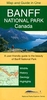
£19.95
Banff & the surrounding area of the Banff National Park in Alberta at 1:50, 000 in a series of GPS compatible recreational maps at various scales from Go Trekkers highlighting recreational possibilities including trekking and/or snowshoe trails, canoeing & kayaking routes, campgrounds, warden stations, etc. Cartography of each title varies according to the terrain of the national park, but the maps are contoured & have spot heights plus, as appropriate, graphics to show wetlands, relief shading in mountainous areas, etc. All the titles are GPS compatible with either a UTM or latitude/longitude grid. Presentation of trails, recreational facilities such as campgrounds, access to the park by road or air, etc, also varies according to what each park has to offer & where it is situated. Each map also

Includes::
notes about the park.

...
Archived Product
£5.59
Map No. 29, Banff & Huntly, in the Ordnance Survey Landranger series at 1:50, 000, including Portsoy, Turriff, Aberchirder, Macduff, Cullen Portknockie, Findochty, Kirktown of Deskford, Cornhill, Kirktown of Alvah, Pennan, Gardenstown, Netherbrae, Fintry, New Byth, Bogton, Cuminestown, Inverkeithny, Howe of Teuchar, Kirkton of Auchterless, Milltown of Rothiemay, Cairnie, Largue, Cpttown, Fyvie, Rothienorman, Craigdam, Kirkton of Culsalmond, Bainshole, Bridgend & Gartly, with Strathbogie, Strath Isla, Knock Hill, Black Hill & Bin of Cullen. Edition B2; Publication date February 2008 About Ordnance Survey ...
Archived Product
£9.09
Map No. 29, Banff & Huntly, in the waterproof & tear-resistant OS Active version of the Ordnance Survey Landranger series at 1:50, 000, including Portsoy, Turriff, Aberchirder, Macduff, Cullen Portknockie, Findochty, Kirktown of Deskford, Cornhill, Kirktown of Alvah, Pennan, Gardenstown, Netherbrae, Fintry, New Byth, Bogton, Cuminestown, Inverkeithny, Howe of Teuchar, Kirkton of Auchterless, Milltown of Rothiemay, Cairnie, Largue, Cpttown, Fyvie, Rothienorman, Craigdam, Kirkton of Culsalmond, Bainshole, Bridgend & Gartly, with Strathbogie, Strath Isla, Knock Hill, Black Hill & Bin of Cullen. Edition B2; Publication date April 2012 About Ordnance Survey ...
Archived Product
£10.39
Map No. 29, Banff & Huntly, in a waterproff & tear-resistant version of the Ordnance Survey Landranger series at 1:50, 000, including Portsoy, Turriff, Aberchirder, Macduff, Cullen Portknockie, Findochty, Kirktown of Deskford, Cornhill, Kirktown of Alvah, Pennan, Gardenstown, Netherbrae, Fintry, New Byth, Bogton, Cuminestown, Inverkeithny, Howe of Teuchar, Kirkton of Auchterless, Milltown of Rothiemay, Cairnie, Largue, Cpttown, Fyvie, Rothienorman, Craigdam, Kirkton of Culsalmond, Bainshole, Bridgend & Gartly, with Strathbogie, Strath Isla, Knock Hill, Black Hill & Bin of Cullen. Edition B2; Revised 1999; Revised for selected changes 2002, 2008; Copyright date 2008 This title is also available on our website in a paper version. Maps in this series are only published folded. Stanfords can also print flat versions of Ordnance Survey maps through the OS Select system, centring the map on a location of your choice & with a picture provided by you on the cover. For more information please click on the link at the bottom of this description. About Ordnance Survey ...
Archived Product
£7.50
A tourist road map covering almost all of the Banff & Jasper NP area, with notes on local attractions & a selection of city plans. excluding only the north-west extremity of Jasper NP. Road detail distinguishes unpaved & gravel roads, & indicates intermediate distances on major routes. Railways & airports are also included. There is no graphic relief detail, but highland ranges are named & many peak altitudes are shown. However colours are used to distinguish National Parks, reserves & icefields. Places of interest are marked & symbols show the locations of tourism features eg. campsites, lodges, skiing areas, picnic areas, guest-ranches & viewpoints. Latitude & longitude lines are drawn at 1 ...
Archived Product
£12.50
Banff National Park with the adjoining Yoho & Kootenay National Parks on a contoured overview map at 1:250, 000 from Gem Trek Publishing showing locations of various tourist facilities & main hiking trails, plus extensive notes on the reverse about the park & what it has to offer. The map fills a gap between the publishers’ overview maps of Banff with Jasper NP or the Icefields Parkway, both at 1:400, 000, & the more detailed coverage of the area by their hiking series at better scales. Road network indicates unpaved & gravel roads in variable condition, with driving distances on main routes. Also marked is the railway line along the Columbia River. Topography is shown by contours at 200m intervals but the peak heights are given in both metres & feet, with plenty of names of various geographic features such as individual mountain ranges, valleys, peaks & passes, etc. The map indicates the boundaries of the national parks & other protected areas & shows main hiking trails. Symbols indicate locations of visitor centres, campgrounds, hostels, chalets & lodges, picnic areas, car parks, riding stables, etc. The map has a latitude & longitude grid at intervals of 15’. The whole of the reverse side is covered by extensive notes about the various aspects of the park, including its history, geology, eco-communities, wildlife, etc. Current edition of this map was published in 2000. ...
Archived Product
£4.99
Banff National Park in the Moon Spotlight guide series; covering a range of specific local cities, districts, areas & regions in North, Central & South America & targeted at those seeking to travel to a specific area within a country. Each of the guides has been extracted in full from the relevant country Moon Handbook & individual titles focus on a particular city, region or notable area of the destination. Many of the guides in the series are unique in their coverage, although are limited in putting the destination into its wider geographical context that a more comprehensive guide would provide. Stylistically, Moon ...
Archived Product
£5.99
Moon Spotlight Banff National Park is an 80-page compact guide covering the best of this scenic wilderness reserve, including Fairmont Banff Springs, Sunshine Meadows, Lake Louise, & Cascade Gardens. Travel writer & photographer Andrew Hempstead offers his firsthand advice on what sights are must-sees, & sightseeing highlight maps make planning your time easy. This lightweight guide is packed with recommendations on sights, entertainment, shopping, recreation, accommodations, food, & transportation. Helpful maps guide travelers through this vast, picturesque destination. This Spotlight guidebook is excerpted from Moon Canadian Rockies. ...
Archived Product
£9.99
The northern part of the Banff National Park on a double-sided, contoured, GPS compatible recreational map at 1:100, 000 from the National Geographic printed on light, waterproof & tear-resistant synthetic paper. Coverage

Includes::
Lake Louise, the Saskatchewan River Crossing & the Columbia Icefield. This title is part of a series of four recreational maps of the Banff & Jasper National Parks from the National Geographic Society. Each map is double-sided to cover a wider area. Topography is very vividly presented by contours at 30m intervals enhanced by relief shading & altitude colouring. Heights are given both in feet & metres. Boundaries of the region’s numerous protected areas indicate their official status, from national parks to provincial natural areas. Road network shows enhanced roads, routes requiring high clearance vehicles & restricted access administrative roads. The marking for maintained trails differentiates between routes for hiking & horse riding & those also suitable for bikes. The trails are annotated with distances in both miles & kilometres. A very wide range of symbols highlights local facilities & recreational areas: different types of accommodation including campgrounds, cabins & hostels, parking & picnic areas, trailheads, horse riding facilities, boat tours, etc. The maps have a 1-km UTM grid plus latitude & longitude crosshairs at 10’. Each title also

Includes::
general information about the region, safety tips, & useful contact details.


...
Archived Product
£9.99
The southern part of the Banff National Park on a double-sided, contoured, GPS compatible recreational map at 1:100, 000 from the National Geographic printed on light, waterproof & tear-resistant synthetic paper. Coverage extends to the southern boundary of the Kootenay National Park, with a wide overlap & Banff village shown on both sides of the map. This title is part of a series of four recreational maps of the Banff & Jasper National Parks from the National Geographic Society. Each map is double-sided to cover a wider area. Topography is very vividly presented by contours at 30m intervals enhanced by relief shading & altitude colouring. Heights are given both in feet & metres. Boundaries of the region’s numerous protected areas indicate their official status, from national parks to provincial natural areas. Road network shows enhanced roads, routes requiring high clearance vehicles & restricted access administrative roads. The marking for maintained trails differentiates between routes for hiking & horse riding & those also suitable for bikes. The trails are annotated with distances in both miles & kilometres. A very wide range of symbols highlights local facilities & recreational areas: different types of accommodation including campgrounds, cabins & hostels, parking & picnic areas, trailheads, horse riding facilities, boat tours, etc. The maps have a 1-km UTM grid plus latitude & longitude crosshairs at 10’. Each title also

Includes::
general information about the region, safety tips, & useful contact details.

...
Archived Product

Banff National Park

Contoured map of the Banff National Park, with the adjoining parks of Yoho, Kootenay, Mount Assiniboine and Kananaskis. Topography is show by contours at 650 feet (approx. 200 metres) intervals and altitude colouring. The map shows roads, gravel tracks and trails, and highlights points of interest, information centres, accommodation facilities, campsites and RV parks, etc. Geographical coordinates are given by margin ticks at 15
RIP - This product is no longer available on our network. It was last seen on 25.09.2019

This page now acts as a permanent archive for this product. Add more information using the comments box below to ensure it can still be found by future generations.

Use our search facility to see if it is available from an alternative contributor.
  • External links may include paid for promotion
  • Availability: Out Of Stock
  • Supplier: Stanfords
  • SKU: 9781553418566
Availability: In Stock
£8.95

Product Description

Contoured map of the Banff National Park, with the adjoining parks of Yoho, Kootenay, Mount Assiniboine & Kananaskis. Topography is show by contours at 650 feet (approx. 200 metres) intervals & altitude colouring. The map shows roads, gravel tracks & trails, & highlights points of interest, information centres, accommodation facilities, campsites & RV parks, etc. Geographical coordinates are given by margin ticks at 15

Reviews/Comments

Add New

Price History

Vouchers

No voucher codes found.
Do you know a voucher code for this product or supplier? Add it to Insights for others to use.

Facebook

Jargon Buster

Metres - A unit of measure, one metre equals 100 centimetres
Gravel - A size of rock between 2mm and 64mm
Altitude - Something that can be quite high in relation to sea or ground level.
Accommodation - A room in which someone can live in, for example in a hotel

Supplier Information

Stanfords
Stanfords was established in 1853 and opened their iconic Covent Garden flagship store in 1901. They have become the top retailer of maps, travel books and accessories in the UK and arguably offer the largest selection of maps and travel books worldwide. Famous names such as Captain Robert Falcon Scott, Ranulph Fiennes and Michael Palin have purchased from Stanfords. They now have a shop in Bristol and both stores together with other venues operate a calendar of events including talks, book signings and exhibitions. As a specialist map retailer, the map selection is comprehensive and includes road maps, street maps and walking maps from worldwide destinations, as well as a selection of world atlases and wall maps. Books include travel guides and travel literature. Stanfords also stock globes, from miniatures made of blue marble to magnificent floor-standing globes. The website features a selection of interesting articles on travel topics.
Page Updated: 2023-11-12 20:15:36

Community Generated Product Tags

Oh No! The productWIKI community hasn't generated any tags for this product yet!
Menu