
 United Kingdom
 France
 Germany
 Netherlands
 Sweden
 USA
USA
 Italy
Italy
 Spain
Spain
More From Contributor


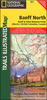
Banff And Jasper
A tourist road map covering almost all of the Banff and Jasper NP area, with notes on local attractions and a selection of city plans. excluding only the north-west extremity of Jasper NP. Road detail distinguishes unpaved and gravel roads, and indicates intermediate distances on major routes. Railways and airports are also included. There is no graphic relief detail, but highland ranges are named and many peak altitudes are shown. However colours are used to distinguish National Parks, reserves and icefields. Places of interest are marked and symbols show the locations of tourism features eg. campsites, lodges, skiing areas, picnic areas, guest-ranches and viewpoints. Latitude and longitude lines are drawn at 1
Product Description
Reviews/Comments
Add New
Vouchers
No voucher codes found.
Do you know a voucher code for this product or supplier? Add it to Insights for others to use.
Do you know a voucher code for this product or supplier? Add it to Insights for others to use.
 Denmark