
 United Kingdom
 France
 Germany
 Netherlands
 Sweden
 USA
USA
 Italy
Italy
 Spain
Spain
More From Contributor


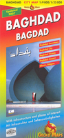
Baghdad
Detailed, indexed street plan of Baghdad, updated in 2007 to show security zones and restricted access areas, with an enlargement of the city centre, a map of the airport zone, and a road map of the wider environs of the city. The main map at 1:25, 000 shows the central part of the city and the surrounding suburbs, including the Sadr City. Main streets have names, otherwise just the names of districts are shown. Boundaries of the special access Green Zone are clearly marked. A wide range of symbols, graphics and colours indicate various places of interest, including hotels, public buildings, monuments, religious establishments, etc. Main shopping streets and areas are highlighted. On the reverse, the central part of the city along the Tigris is shown in greater detail at 1:9,
000. The plans have an index listing street, neighbourhoods, public buildings, embassies, hotels, shops, etc.The restricted Green Zone around the city’s international airport is shown at 1:25, 000. A general map of the central part of Iraq at 1:850, 000 extends north to Kirkuk and south to Karbala and Al-Hillah. Also included is a small ethno-religious map of the whole country. All place names are in Roman alphabet only. Names of public buildings and various facilities are in English. Map legend is in English and German
000. The plans have an index listing street, neighbourhoods, public buildings, embassies, hotels, shops, etc.The restricted Green Zone around the city’s international airport is shown at 1:25, 000. A general map of the central part of Iraq at 1:850, 000 extends north to Kirkuk and south to Karbala and Al-Hillah. Also included is a small ethno-religious map of the whole country. All place names are in Roman alphabet only. Names of public buildings and various facilities are in English. Map legend is in English and German

Product Description
Reviews/Comments
Add New
Intelligent Comparison
Archived Product
Baghdad Stanfords
£8.95
Archived Product
Baghdad Stanfords
£8.95
Archived Product
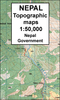
Bahundada Stanfords
£9.99
Archived Product

Bad Dad Stanfords
£12.99
Archived Product

Bad Dad Stanfords
£9.99
Vouchers
No voucher codes found.
Do you know a voucher code for this product or supplier? Add it to Insights for others to use.
Do you know a voucher code for this product or supplier? Add it to Insights for others to use.
 Denmark