More From Contributor
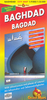
£6.95
Topographic coverage of mainland Spain at 1:50, 000 in the MTN50 (Mapa Topográfico Nacional) series from the Centro Nacional de Información Geografica, the country’s civilian survey organization. The maps have contours at 20m intervals, enhanced by relief shading, plus colouring and/or graphics to show different types of terrain, vegetation or land use. Boundaries of national parks & other protected areas are marked. In addition to all the usual information featured on topographic mapping at this scale, detailed presentation of the road & rail networks, rural tracks & paths, etc, the maps also show campsites & mountain refuges. On more recent editions some GRs, the official long-distance hiking routes, are also marked (although not as clearly as on hiking maps from other publishers). Each map covers 29.5x 18.5 km (with adjustments in the border or coastal areas). The maps have a 1-km UTM grid, plus margin ticks for latitude & longitude at 1` intervals. Map legend is in Spanish only.HOW TO CHOOSE THE RIGHT 50K MAP: all the titles in CNIG’s 200K Provincial Road Maps series at 1:200, 000 are overprinted with the grid for the 1:50, 000 maps & can be used to see the area covered by each 50K title. TO SEE THE LIST OF TITLES IN THIS SERIES PLEASE CLICK ON THE SERIES LINK.PLEASE NOTE
- MAP TITLES: the grids shown on our website serve both the civilian & the military 1:50, 000 topographic series. Although the areas covered by maps in both series are identical (apart from some border or coastal sheets), occasionally map titles differ – only one title is shown on the grid, usually the military one. In Galicia, the Basque country & in the Catalan speaking areas the tendency now is to use local place names rather than the often better known Castilian ones. Where possible, both versions are included in our titles. Map titles listed on our website are based on information received by us at the time of publication, but sometimes maps arrive showing a completely different title! As long as the map number is as ordered, the correct map has been supplied.
...
Archived Product
£36.95
Military topographic survey mapping with contours. These maps are designed primarily as flying charts for aircraft, but they are useful as general topographical maps where nothing else is available. Contours are shown in feet, with elevation colouring & spot heights. Towns, villages, major roads, railways & airports are shown (but please note that many of the smaller settlements are not named, & the road information is not necessarily up to date). Some air navigation information also appears on the map, such as radio beacons & restricted flying zones. Double-sided sheet. ...
Archived Product
£9.99
Bagarchhap, sheet no. 2884-06, in the topographic survey of Nepal at 1:50, 000 published by the Nepali Government in the late 1990s & early 2000s & produced from remote sensing data by Finnish cartographers as part of that country’s international aid program. The maps cover 15’ x 15’ quadrangles.IMPORTANT – PLEASE NOTE BEFORE ORDERING: AVAILABILITY: although, theoretically at least, still in print, these maps are very difficult to get locally in Nepal and/or from various suppliers elsewhere specializing in obtaining such maps. DELIVERIES MAY TAKE SEVERAL WEEKS OR EVEN MONTHS.PROBLEMS WITH PLACE NAMES: reports from previous users indicate that transliteration of place names differs from that used widely not only on other maps & in guide books but also on the ground itself, in road signs & in the tourist & trekking industry in general. Whilst most names are similar enough to be easily recognizable, e.g. Namche Bajar for Namche Bazar or Lantan for Langtang, we have been told of confusion & difficulties arising from different spellings appearing on these maps.TREKKING ROUTES & TOURIST INFORMATION: whilst the maps show foot trails & mark locations of temples, etc, they carry no specific trekking information. Major trekking routes & places of interest are not highlighted. There is no marking for base camps & other tourist facilities. Map specifications: Contours are at 40m intervals, with graphics and/or coloring to show various features of the terrain (glaciers with moraines & crevasses, quarries, gravel or clay pits, etc.) & vegetation (forests, bush, grass, orchards & plantations, etc). Additional comments such as “open mixed forest mainly bajh & pine” annotate many area. The maps have numerous spot heights, but relatively few peaks are named. Areas outside the country’s borders are left blank. Settlements in remote areas are indicated by markings for individual buildings & the placing of names does not always make it clear which group of buildings they refer to. Road network distinguishes between major & minor foot trails. Symbols mark features such as temples, schools & hospitals, police stations, etc. Also shown are the country’s administrative divisions. The maps have a 1-km UTM grid, plus latitude & longitude lines at intervals of 5’. Map legend & all the text is in English. Coverage: the whole country is now covered, with the north at 1:50, 000, plus central & southern Nepal at 1:25, 000. The two series are complementary, do not overlap & use the same grid & numbering system (apart from the Lumbini Zone, where a different grid & numbering are used). For areas not shown on our grid & titles not listed here, please contact us by e-mail, but please do bear in mind the problems with availability & the likely very long delivery time. ...
Archived Product
£12.99
” Bagels & Bacon” is a rites of passage story that will appeal to both young & old. It attempts to shed a largely humorous, but sometimes serious light, on the relations between an ethnic minority & the wider community. Its attitude to Judaism, in particular, & religions in general, is irreverent. The work is also a nostalgic record of growing up in the East End during the postwar period, & attempts to convey a liking of London & more importantly a love of history to the reader. Within the Jewish community it might arouse interest, even controversy, but in wider terms it tries to portray the East End before the dawn of multiculturalism & political correctness. The author, a baby boomer (now turned pensioner) tells with genuine affection & warmth his family story peopled by a host of hilarious characters. ...
Archived Product
£10.99
Topographic survey of Catalonia at 1:50, 000 from the Institut Cartogràfic de Catalunya, with vivid presentation of the terrain & an overprint for long-distance GR hiking trails. The series provides an excellent alternative to the much smaller sheets in the civilian or military surveys produced for the whole of Spain. The Catalan 50K series has not only a much larger area per sheet (each map covers one comarca, an administrative division of a province) than the maps from the national surveys, but also has more colourful, elegant & clear cartography with contours at 20m intervals, hill shading & fine graphics to portray the relief, vegetation types & landmarks. Most maps also have more tourist-related information, with an overprint highlighting long-distance GR trails & the Via Verde routes. Mountain refuges are marked & a range symbols indicate various places of interest including historical monuments, sport & recreational facilities, etc. Four different types of interesting locations are highlighted: picturesque towns or villages, individual isolated building or monuments, natural sites, & hydrographic features such as waterfalls. The maps have a 5km UTM grid, with latitude & longitude values shown for the map corners. Map legend is in Catalan only. To see other titles in this series please click on the series link. ...
Archived Product
£12.99
Detailed, indexed street plan of Baghdad, updated in 2007 to show security zones & restricted access areas, with an enlargement of the city centre, a map of the airport zone, & a road map of the wider environs of the city. The main map at 1:25, 000 shows the central part of the city & the surrounding suburbs, including the Sadr City. Main streets have names, otherwise just the names of districts are shown. Boundaries of the special access Green Zone are clearly marked. A wide range of symbols, graphics & colours indicate various places of interest, including hotels, public buildings, monuments, religious establishments, etc. Main shopping streets & areas are highlighted. On the reverse, the central part of the city along the Tigris is shown in greater detail at 1:9, 000. The plans have an index listing street, neighbourhoods, public buildings, embassies, hotels, shops, etc. The restricted Green Zone around the city’s international airport is shown at 1:25, 000. A general map of the central part of Iraq at 1:850, 000 extends north to Kirkuk & south to Karbala & Al-Hillah. Also included is a small ethno-religious map of the whole country. All place names are in Roman alphabet only. Names of public buildings & various facilities are in English. Map legend is in English & German ...
Archived Product
£8.95
A clear street plan covering an area of about 7 x 7 miles. Main roads are named & railways are included. The old city is highlighted & a variety of the city's features are indicated, eg. places of worship, museums, parks, antiquities, monuments, hotels, markets, public offices. Lines of latitude & longitude are drawn at 1' intervals. Small inset maps show the environs of Baghdad at 1:1, 750, 000 & Iraq & neighbours at 1:6, 000, 000. The index

Includes::
streets, quarters of the city & sites of interest eg. mosques, churches, markets, notable buildings.

...
Archived Product
£8.99
Baghdad, November 2003. The US occupation is not yet a disaster but the CPA has disbanded the Iraqi army & decimated the police in its policy of de-Ba`athification of Iraqi society. Inspector Muhsin al-Khafaji is a mid-level Iraqi cop who deserted his post back in April. Khafaji has lived long enough in pre- & post-Saddam Iraq to know that clinging on to anything but poetry & his daughter, Mrouj, is asking for trouble. Nabbed by the Americans & imprisoned in Abu Ghraib, Khafaji is offered only one way out
- he has to work for the CPA to rebuild the Iraqi Police Services. But it`s only after US forces take Mrouj that he figures out a way to make his collaboration palatable, & even rewarding. Soon, he is investigating the disappearance of young translators working for the US Army.
...
Archived Product
£12.99
The latest in Andrew Martin’s much loved ‘ Jim Stringer’ series of books, The Baghdad Railway Club is set in Baghdad 1917 as Captain Jim Stringer, invalided from the Western Front, has been dispatched to investigate what looks like a nasty case of treason. Arriving to find a city on the point of insurrection, his own cover apparently blown, Stringer finds his only contact lying dead with flies in his eyes. Baghdad swelters in a particularly torrid summer, the heat alone threatens the lives of the British soldiers who occupy the city. The recently ejected Turks are still a danger
- & many of the local Arabs are none too friendly either. For Jim, who is not particularly good in warm weather, the situation grows pricklier by the day. Aside from his investigation, he is working on the railways around the city. His boss is the charming, enigmatic Lieutenant-Colonel Shepherd, who presides over the gracious dining society called The Baghdad Railway Club
- & who may or may not be a Turkish agent. Jim`s search for the truth brings him up against murderous violence in a heat-dazed, labyrinthine city where an enemy awaits around every corner. The Baghdad Railway Club continues the ` Jim Stringer` series which began with The Necropolis Railway in 2002. The third & fourth books in the series, Murder at Deviation Junction & Death on a Branch Line, were shortlisted for the Ellis Peters Historical Crime Award &, in 2008, Andrew Martin was shortlisted for the CWA Dagger in the Library Award.

...
Archived Product
£9.99
The Freya Stark Collection Freya Stark first journeyed to Iraq in 1927. Seven years after the establishment of the British Mandate, the modern state was in its infancy & worlds apart from the country it has since become. During her many years in Iraq, Freya Stark was witness to the rise & fall of the British involvement in the country as well as the early years of independence. Typically
- & controversially
- she chose to live outside the close-knit western expatriate scene & immersed herself in the way of life of ordinary Iraqis
- living in the `native` quarter of the city & spending time with its tribal sheikhs & leaders. Venturing out of Baghdad, she travelled to Mosul, Nineveh, Tikrit & Najaf, where she perceptively describes the millennia-old tensions between Sunni & Shi`a, time not having dissipated their hatred. In the 1940s she returned again, this time travelling south, to the Marsh Arabs, whose way of life has now all but disappeared; north into Kurdistan & later, Kuwait, in the days before the oil boom. Painting a portrait of both the political & social preoccupations of the day as exquisitely as she does the people & landscapes of Iraq, Baghdad Sketches is a remarkable portrait of the country as it once was.


...
Archived Product

Baghdad

Double-sided sheet with main map of Baghdad at 1:25, 000 scale, key to symbols and an index on one side and on the reverse an enlargement at 1:9, 000 of Baghdad city centre, a map of the capital's environs, a map showing No Fly Zones, a diagram of the ranges of Scud-B and Al-Hussein missiles with oil fields and US airbases, a map showing alleged locations of active and unactive nuclear infrastructures, chemical and nuclear weapons.
RIP - This product is no longer available on our network. It was last seen on 25.09.2019

This page now acts as a permanent archive for this product. Add more information using the comments box below to ensure it can still be found by future generations.

Use our search facility to see if it is available from an alternative contributor.
  • External links may include paid for promotion
  • Availability: Out Of Stock
  • Supplier: Stanfords
  • SKU: 9781553416050
Availability: In Stock
£8.95

Product Description

Double-sided sheet with main map of Baghdad at 1:25, 000 scale, key to symbols & an index on one side & on the reverse an enlargement at 1:9, 000 of Baghdad city centre, a map of the capital's environs, a map showing No Fly Zones, a diagram of the ranges of Scud-B & Al-Hussein missiles with oil fields & US airbases, a map showing alleged locations of active & unactive nuclear infrastructures, chemical & nuclear weapons.

Reviews/Comments

Add New

Price History

Vouchers

No voucher codes found.
Do you know a voucher code for this product or supplier? Add it to Insights for others to use.

Facebook

Jargon Buster

Oil - A hydrophobic liquid with high carbon and hydrogen content. Has many variations including; cooking oils, petrochemical oils, essential oils.
Key - A physical or virtual device or code used for opening something

Supplier Information

Stanfords
Stanfords was established in 1853 and opened their iconic Covent Garden flagship store in 1901. They have become the top retailer of maps, travel books and accessories in the UK and arguably offer the largest selection of maps and travel books worldwide. Famous names such as Captain Robert Falcon Scott, Ranulph Fiennes and Michael Palin have purchased from Stanfords. They now have a shop in Bristol and both stores together with other venues operate a calendar of events including talks, book signings and exhibitions. As a specialist map retailer, the map selection is comprehensive and includes road maps, street maps and walking maps from worldwide destinations, as well as a selection of world atlases and wall maps. Books include travel guides and travel literature. Stanfords also stock globes, from miniatures made of blue marble to magnificent floor-standing globes. The website features a selection of interesting articles on travel topics.
Page Updated: 2023-11-12 20:15:36

Community Generated Product Tags

Oh No! The productWIKI community hasn't generated any tags for this product yet!
Menu