
 United Kingdom
 France
 Germany
 Netherlands
 Sweden
 USA
USA
 Italy
Italy
 Spain
Spain
More From Contributor


Azores
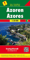
The Azores map at 1:50, 000 on a large double sided road map from Turinta with cartography from Freytag & Berndt, shows the islands both individually and as a group with the surrounding islands.This map shows main and minor roads, motorways and toll roads, sections under construction or closed to traffic. Conveniently highlighted are scenic routes, gradients on steep roads, driving distances in kilometres, petrol and service stations etc. Railway lines are marked and international and local airports are indicated as well as ferry connections to the other islands. Relief shading, spot heights and colouring and/or graphics provide a good presentation of the islands topography. Natural reserves are marked and symbols indicate various places of interest and facilities, e.g. museums,
churches and castles, viewpoints, beaches, campsites and motels, etc. Latitude and longitude lines are drawn at 2' intervals. A small inset shows the islands together as a group and ferry and domestic airlines connection within the islands.The multilingual legend includes English. Please note: maps of the Azores by Turinta and by Freytag & Berndt use identical cartography, although the Turinta version does not include A booklet with an index and descriptions of sights.
churches and castles, viewpoints, beaches, campsites and motels, etc. Latitude and longitude lines are drawn at 2' intervals. A small inset shows the islands together as a group and ferry and domestic airlines connection within the islands.The multilingual legend includes English. Please note: maps of the Azores by Turinta and by Freytag & Berndt use identical cartography, although the Turinta version does not include A booklet with an index and descriptions of sights.
Product Description
Reviews/Comments
Add New
Intelligent Comparison
Archived Product
Azores Stanfords
£4.99
Archived Product
Azores Stanfords
£14.95
Archived Product
Azores Stanfords
£9.50
Archived Product
Azores Stanfords
£12.99
Archived Product
Azores Stanfords
£15.99
Archived Product
Azores F&B Stanfords
£10.99
Archived Product
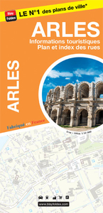
Arles Stanfords
£6.99
Vouchers
No voucher codes found.
Do you know a voucher code for this product or supplier? Add it to Insights for others to use.
Do you know a voucher code for this product or supplier? Add it to Insights for others to use.
 Denmark