
 United Kingdom
 France
 Germany
 Netherlands
 Sweden
 USA
USA
 Italy
Italy
 Spain
Spain
More From Contributor


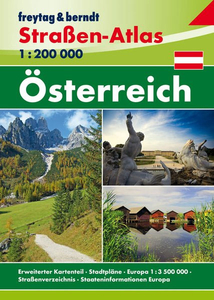
Austria Railway Atlas
Detailed atlas of the Austrian rail infrastructure, in hardback format, published by Schweers & Wall. In addition to the pages covering the country at 1:150, 000, there are larger scale detailed plans, at a scale of 1:50, 000, for selected urban areas including Vienna, Linz, Salzburg, Innsbruck, Graz and Villach. Tram and Metro networks in Vienna, Linz, Innsbruck and Graz are also shown.The cartography distinguishes the many variations in the railway network: public, tourist and private lines, local and main lines, double and single track, abandoned and out of use lines, narrow gauge lines, cableways, rack railways, metros and tramways. Colours also indicate electrical system variations, and tunnels, stations, crossovers, marshalling yards, sidings, workshops,
etc. are indicated. Additional details include cumulative distances at stations, gradients, national and provincial borders, motorways, industrial works, rivers, lakes and forested areas. Hill shading shows the general relief and altitudes of stations and selected peaks are shown.The legend is in German, English, French and Italian, and introductory text is in English and German. Operating companies are listed and general maps portray various themes eg. private railways, terminals, narrow guage railways, rail traffic density. The atlas is indexed for place names and tunnels.
etc. are indicated. Additional details include cumulative distances at stations, gradients, national and provincial borders, motorways, industrial works, rivers, lakes and forested areas. Hill shading shows the general relief and altitudes of stations and selected peaks are shown.The legend is in German, English, French and Italian, and introductory text is in English and German. Operating companies are listed and general maps portray various themes eg. private railways, terminals, narrow guage railways, rail traffic density. The atlas is indexed for place names and tunnels.

Product Description
Reviews/Comments
Add New
Intelligent Comparison
Archived Product
China Railway Atlas Stanfords
£20.00
Archived Product
Australia Road Atlas Stanfords
£11.99
Archived Product
Australia Road Atlas Stanfords
£20.95
Archived Product
Australia Road Atlas Stanfords
£11.99
Archived Product
Ukraine Railway Atlas Stanfords
£11.95
Archived Product
Ukraine Railway Atlas Stanfords
£12.99
Archived Product
Austria F&B Road Atlas Stanfords
£13.99
Archived Product

ABC British Railway Atlas Stanfords
£11.00
Vouchers
No voucher codes found.
Do you know a voucher code for this product or supplier? Add it to Insights for others to use.
Do you know a voucher code for this product or supplier? Add it to Insights for others to use.
 Denmark