
 United Kingdom
 France
 Germany
 Netherlands
 Sweden
 USA
USA
 Italy
Italy
 Spain
Spain
More From Contributor


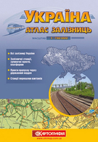
Ukraine Railway Atlas
Ukraine Railway Atlas from Kartografija in Kiev in an A5 paperback format with detail presentation of the network, including enlargements for 11 main cities plus an index of railway stations. All place names are in the Cyrillic alphabet and the map legend is in Ukrainian only. Coverage includes the Crimea.All lines are graded according to the number of tracks, their gauge and electric traction. Connecting lines outside the county borders are also shown. Stations are also graded and intermediate distances are marked. The base map is coloured to show the country’s division into administrative railway sectors. Topographic information is limited to rivers and lakes, although some relief shading is provided in the Carpathian Mountains.Enlargements at 1:200, 000/1:250, 000 show in greater
detail the environs of 11 main cities, including Kiev, Lviv and Odessa. The atlas has an index of stations and a comprehensive distance table. Map legend is in the Ukrainian only.IMPORTANT - PLEASE NOTE BEFORE ORDERING: supplies of all titles published in the Ukraine are irregular and we cannot guarantee a firm delivery time. When a title is out of stock, it may be advisable to choose an alternative publication.
detail the environs of 11 main cities, including Kiev, Lviv and Odessa. The atlas has an index of stations and a comprehensive distance table. Map legend is in the Ukrainian only.IMPORTANT - PLEASE NOTE BEFORE ORDERING: supplies of all titles published in the Ukraine are irregular and we cannot guarantee a firm delivery time. When a title is out of stock, it may be advisable to choose an alternative publication.

Product Description
Reviews/Comments
Add New
Vouchers
No voucher codes found.
Do you know a voucher code for this product or supplier? Add it to Insights for others to use.
Do you know a voucher code for this product or supplier? Add it to Insights for others to use.
 Denmark