
 United Kingdom
 France
 Germany
 Netherlands
 Sweden
 USA
USA
 Italy
Italy
 Spain
Spain
More From Contributor


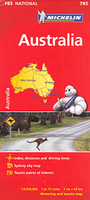
Australia Michelin
Australia at 1:4, 500, 000 on a large indexed map from Michelin providing an overview of the road network on a clear base highlighting protected areas, with an enlargement for the Sydney region and a distance table.The base map has subtle relief shading to show the Great Dividing Range along the eastern coastline; in the interior many seasonal river and lakes marked. Numerous national parks and selected other protected areas, as well as Aboriginal lands are prominently highlighted. Road network includes selected Outback tracks and, where appropriate, gives both numbers and names of highways. Main railway lines are also included, although in places not easy to distinguish from unsurfaced road tracks. Latitude and longitude lines are drawn at 4° intervals. The index is next to the
map.Also provided is an inset showing the environs of Sydney in greater detail, a distance table listing 26 locations, plus information on basic traffic regulations.
map.Also provided is an inset showing the environs of Sydney in greater detail, a distance table listing 26 locations, plus information on basic traffic regulations.

Product Description
Reviews/Comments
Add New
Intelligent Comparison
Archived Product
Austria Michelin Stanfords
£5.99
Archived Product
Tunisia Michelin Stanfords
£5.99
Archived Product

Bulgaria Michelin Stanfords
£5.99
Archived Product

Brazil Michelin Stanfords
£5.99
Archived Product

Cuba Michelin Stanfords
£5.99
Archived Product

Croatia Michelin Stanfords
£5.99
Archived Product
Romania Michelin Stanfords
£5.99
Archived Product
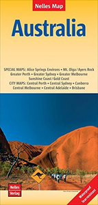
Australia Nelles Stanfords
£10.99
Vouchers
No voucher codes found.
Do you know a voucher code for this product or supplier? Add it to Insights for others to use.
Do you know a voucher code for this product or supplier? Add it to Insights for others to use.
 Denmark