More From Contributor
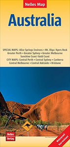
£9.99
Marco Polo Spiral Guides are for travelers who have little time to prepare for a trip, don t want to miss anything, like to be inspired by great ideas for exciting days out & love all things ultra-practical & easy to use. Top 10 sights: From the top down to make it easy to prioritise! Don`t miss: Each chapter highlights the absolute must-sees for each area. ...
Archived Product
£5.99
Australia at 1:4, 500, 000 on a large indexed map from Michelin providing an overview of the road network on a clear base highlighting protected areas, with an enlargement for the Sydney region & a distance table. The base map has subtle relief shading to show the Great Dividing Range along the eastern coastline; in the interior many seasonal river & lakes marked. Numerous national parks & selected other protected areas, as well as Aboriginal lands are prominently highlighted. Road network

Includes::
selected Outback tracks &, where appropriate, gives both numbers & names of highways. Main railway lines are also included, although in places not easy to distinguish from unsurfaced road tracks. Latitude & longitude lines are drawn at 4° intervals. The index is next to the map. Also provided is an inset showing the environs of Sydney in greater detail, a distance table listing 26 locations, plus information on basic traffic regulations.

...
Archived Product
£30.95
Motorcycle Road Atlas of Australia form Hema in a handy size, spiral-bound format, describing 200 top routes for exploring the country by motorbike, all highlighted on clear, detailed road maps indicating fuel supplies, caravan parks, national or state parks & other protected areas, etc. In this new, revised 2009 edition 200 routes are now presented, grouped by state & divided into two categories: the 100 top routes each have a separate page in the atlas with a description & photos; the next 100 rides get just a few lines each. The last, 122-page section is a road atlas, presenting each state in a series of maps overprinted with the routes. The maps indicate locations of fuel supplies, rest areas, picnic & camping sites & caravan parks. Scales vary according to the size of the area covered by the map. The maps have latitude lines at intervals of 30 ...
Archived Product
£33.95
Motorcycle Road Atlas of Australia from Hema presented as a set of two spiral-bound books: a state by state road atlas & a separate guide to 200 top rides, plus as a bonus, a folded map of Australia highlighting the routes of 27 best rides.ROAD ATLAS: The 152-page atlas has maps arranged by state, with scales varying according to the size of the state. Road network, shown on a clear base with colouring for national parks & other protected areas plus for Aboriginal lands, distinguishes between sealed & unsealed roads & indicates rough 4WD only tracks. Driving distances are marked on many local roads & tracks & locations of fuel supplies are indicated. Routes recommended in the accompanying guide are clearly highlighted. Symbols indicate camping areas with facilities, caravan parks, rest areas with toilets or overnight accommodation, as well as various places of interest. The maps have no geographical coordinates. The atlas has an extensive index & in addition provides: a street plan of the city centre in the state capital; more detailed mapping of the environs of state capitals & other selected areas; strip maps of main motorway routes; a 5-page table listing facilities in national/state parks; a distance table.200 TOP RIDES GUIDE: Arranged by state, the guide allocates one page each to the first 100 recommendations with a description, colour photos & details of distance, information points, etc. Rides 101 to 200 have shorter descriptions of three/four sentences. Each ride is cross-referenced to the road atlas.THE BONUS MAP:A large, 100x 87cm map of Australia showing the country ...
Archived Product
£16.99
Australia on a wall map at 1:6, 413, 000,

Size:
77 x 60cm (30” x 24” approx) – encapsulated version, presenting

...
Archived Product
£12.99
Australia on a wall map at 1:6, 413, 000,

Size:
77 x 60cm (30” x 24” approx) – paper version, presenting

...
Archived Product
£12.99
Australia on a wall map at 1:6, 413, 000,

Size:
77 x 60cm (30” x 24” approx) – paper version, from the

...
Archived Product
£6.99
Australia on an overview map from Periplus accompanied by enlargements of its most visited areas plus street plans of the five main cities, shown on panels on both sides of the sheet. All the maps are annotated with numerous places of interest & street plans in addition show locations of hotels. A general map covers the country at 1:7, 700, 000 showing the network of main roads & railways, principal national parks & aboriginal lands. Separate panels with more detailed road maps & street plans show provide coverage of:
- REGIONAL MAPS: Sydney with the Blue Mountains National Park & extending north to Newcastle, plus Brisbane with Gold Coast (both at 1: 650, 000)- ENVIRONS MAPS: Greater Sydney (1:120, 000), Greater Melbourne (1:150, 000), plus the environs of Cairns, Darwin, Adelaide & Perth (1:250, 000/1:300, 000)- STREET PLANS: Sydney, Melbourne, Brisbane, Adelaide & Perth (1:10, 000/17, 500)
...
Archived Product
£6.99
Australia in the Pocket Guide series from Berlitz; a collection of handy, pocket-sized guides dedicated to an extensive range of cities, regions & countries worldwide. Written in narrative form, individual guides explore the history, main sights & attractions, food & drink, accommodation & local culture of the destination in detail. Each Berlitz pocket guide has a similar format, with colour-coded sections helping readers locate information quickly in addition to distinctive chapters exploring the city or region. An introduction outlines the destination for visitors & a section dedicated to 'A Brief History' actually explores the area in relative depth. A where to go chapter is organized by region & city & is written in prose form with references to individual sites highlighted in bold for clarity. There are also further suggestions on where & when to eat. Recommendations for leisure activities in the region, including sport, nightlife & shopping, are also provided & tailored accordingly for each destination. Handy travel tips are listed alphabetically in a dedicated section, providing practical guidance & helping visitors make the most of their stay. The main hotels, particularly for cities, are also listed in an accommodation section, offering a brief overview with approximate price bandings & relevant contact details. ...
Archived Product

Australia Nelles

Folded road & tourist map of Australia at 1:4, 500, 000 scale. National parks, offshore reefs, and places of interest highlighted, and shaded-relief colouring clearly depicts topography. Insets include greater and central Sydney, Melbourne, Brisbane, & Perth, Canberra, Adelaide, Uluru Kata Tjuta National Park, Mt. Olga, the Sunshine and Gold Coasts & Alice Springs Environs. Legend in English, French and German. Printed in Waterproof paper.
RIP - This product is no longer available on our network. It was last seen on 25.09.2019

This page now acts as a permanent archive for this product. Add more information using the comments box below to ensure it can still be found by future generations.

Use our search facility to see if it is available from an alternative contributor.
  • External links may include paid for promotion
  • Availability: Out Of Stock
  • Supplier: Stanfords
  • SKU: 9783865740700
Availability: In Stock
£10.99

Product Description

Folded road & tourist map of Australia at 1:4, 500, 000 scale. National parks, offshore reefs, & places of interest highlighted, & shaded-relief colouring clearly depicts topography. Insets include greater & central Sydney, Melbourne, Brisbane, & Perth, Canberra, Adelaide, Uluru Kata Tjuta National Park, Mt. Olga, the Sunshine & Gold Coasts & Alice Springs Environs. Legend in English, French & German. Printed in Waterproof paper.

Reviews/Comments

Add New

Intelligent Comparison

Oooops!
We couldn't find anything!
Perhaps this product's unique.... Or perhaps we are still looking for comparisons!
Click to bump this page and we'll hurry up.

Price History

Vouchers

No voucher codes found.
Do you know a voucher code for this product or supplier? Add it to Insights for others to use.

Facebook

Jargon Buster

Gold - A precious highly conductive metal
Paper - A thin sheet mainly used for writing. Available in a variety of colours. Made mainly from wood pulp.
Waterproof - Resistant to water, usualy specified by depth in metres
Road - a manmade lane or a path that is used to speed up travel.
Gold - A colour, a type of rich metal. Chemical symbol AU.

Supplier Information

Stanfords
Stanfords was established in 1853 and opened their iconic Covent Garden flagship store in 1901. They have become the top retailer of maps, travel books and accessories in the UK and arguably offer the largest selection of maps and travel books worldwide. Famous names such as Captain Robert Falcon Scott, Ranulph Fiennes and Michael Palin have purchased from Stanfords. They now have a shop in Bristol and both stores together with other venues operate a calendar of events including talks, book signings and exhibitions. As a specialist map retailer, the map selection is comprehensive and includes road maps, street maps and walking maps from worldwide destinations, as well as a selection of world atlases and wall maps. Books include travel guides and travel literature. Stanfords also stock globes, from miniatures made of blue marble to magnificent floor-standing globes. The website features a selection of interesting articles on travel topics.
Page Updated: 2023-11-12 20:15:36

Community Generated Product Tags

Oh No! The productWIKI community hasn't generated any tags for this product yet!
Menu