
 United Kingdom
 France
 Germany
 Netherlands
 Sweden
 USA
USA
 Italy
Italy
 Spain
Spain
More From Contributor


Anguilla
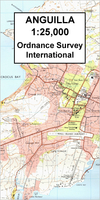
Topographic survey map of Anguilla with the Prickly Pear Cays, plus Dog and Scrub Islands shown as insets. The map has contours at 25 feet intervals and indicates various types of vegetation and terrain: forests, scrub, palms, swamps and mangroves, plantations, cliffs and flat rocks, etc. Built up areas are marked, with schools, churches, police stations, etc. Also shown are wells and water tanks, archaeological sites, local parish boundaries and the island

Product Description
Reviews/Comments
Add New
Intelligent Comparison
Archived Product
Anguilla Stanfords
£7.95
Archived Product
Anguilla Stanfords
£13.99
Archived Product
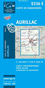
Aurillac Stanfords
£11.50
Archived Product

Angola Stanfords
£9.50
Archived Product

Angola Stanfords
£8.99
Vouchers
No voucher codes found.
Do you know a voucher code for this product or supplier? Add it to Insights for others to use.
Do you know a voucher code for this product or supplier? Add it to Insights for others to use.
 Denmark