
 United Kingdom
 France
 Germany
 Netherlands
 Sweden
 USA
USA
 Italy
Italy
 Spain
Spain
More From Contributor


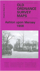
Ashton Upon Mersey 1908
Ashton upon Mersey in 1908 in a fascinating series of reproductions of old Ordnance Survey plans in the Alan Godfrey Editions, ideal for anyone interested in the history of their neighbourhood or family. Selected towns in Great Britain and Ireland are covered by maps showing the extent of urban development in the last decades of the 19th and early 20th century.In this title: this detailed map covers much of Ashton upon Mersey, with coverage extending from Park Road and Washway Road westward to the parish boundary, and from Ashton New Hall southward to Woodheys Farm and Hesketh Road. Features include tramway, Oaklee Farm, St Mary Madgalene church, Macum Farm, graveyard of St Martin's church (church itself just off to the north), Ivy Farm, Ingestre, Green Lane area, Ashton Lane,
Moss Lane, numerous streets of housing - terraced, semi and detached - shown in detail. On the reverse are extracts from a 1906 street directory for Barker's Lane, Beech Grove, Carlton Road, Green Lane, Harboro' Road, Moss Lane, Urban Road. About the Alan Godfrey Editions of the 25
Moss Lane, numerous streets of housing - terraced, semi and detached - shown in detail. On the reverse are extracts from a 1906 street directory for Barker's Lane, Beech Grove, Carlton Road, Green Lane, Harboro' Road, Moss Lane, Urban Road. About the Alan Godfrey Editions of the 25
Product Description
Reviews/Comments
Add New
Intelligent Comparison
Archived Product
Ashton Upon Mersey 1908 Stanfords
£3.50
Archived Product
Ashton-on-Mersey 1927 Stanfords
£2.95
Archived Product
Ashton-on-Mersey 1927 Stanfords
£3.50
Archived Product

Ashton In Makerfield 1906 Stanfords
£3.50
Vouchers
No voucher codes found.
Do you know a voucher code for this product or supplier? Add it to Insights for others to use.
Do you know a voucher code for this product or supplier? Add it to Insights for others to use.
 Denmark