
 United Kingdom
 France
 Germany
 Netherlands
 Sweden
 USA
USA
 Italy
Italy
 Spain
Spain
More From Contributor


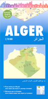
Algiers
Central Algers on an indexed tourist street plan, showing landmarks and places of interest. Coverage extends from the Cathédrale Notre Dame d’Afrique and the European cemetery in the north to the Presidential Palace and the Riadh El Feth complex (Musée du Djihad) in the south.Various public buildings, places of interest and facilities such as hotels, markets, tourist information, railway stations and bus terminals, religions buildings, petrol stations, etc, are highlighted in different colours and/or marked by various icons.On the back cover is a small road map of the city and the Bay of Algiers area showing the Houari Boumediene international airport and main road and rail links.The map has a street index, plus separate lists of points of interest, main governmental
institutions, selected hotels, medical facilities and mosques.The map legend is in English, French and Arabic.
institutions, selected hotels, medical facilities and mosques.The map legend is in English, French and Arabic.

Product Description
Reviews/Comments
Add New
Vouchers
No voucher codes found.
Do you know a voucher code for this product or supplier? Add it to Insights for others to use.
Do you know a voucher code for this product or supplier? Add it to Insights for others to use.
 Denmark