
 United Kingdom
 France
 Germany
 Netherlands
 Sweden
 USA
USA
 Italy
Italy
 Spain
Spain
More From Contributor


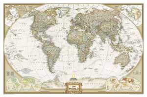
World NGS Executive Wall Map ENCAPSULATED
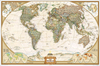
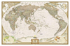
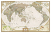
Encapsulated version of the standard size, 116.5 x 77.5cm (46” x 30” approx.), Atlantic centred NGS Executive political map of the world which offers current information presented in elegant antique style. Countries are in rich but muted colours and oceans in beige, with additional panels and framing in shades of brown.An unusual feature of this series is the excellent presentation of the ocean floor, with impressive relief shading to show the continental shelf around the land masses and numerous ridges, many with names. Unfortunately, although clear and very effective on all the sizes of this design, the samples presented here cannot do full justice to such fine detail.On land, the map has relief shading with names of main mountain ranges. Heights for peaks are given in feet.
Within USA boundaries and names of states are shown. Four insets present the Arctic and the Antarctic, plus vegetation/land use and population density world maps. Also provided are lists of 10 largest countries by area and by populations. Projection is Winkel Tripel, which reduces distortion of land masses as they near the poles.NGS Executive Style World Maps are published in three sizes: standard (116.5 x 77.5cm / 46” x 30” approx), enlarged (185 x 122cm / 73” x 48” approx) and a 3-sheet set (296 x 193cm / 9ft 8” x 6ft 4” approx) - TO SEE ALL THE OPTIONS PLEASE CLICK ON THE SERIES LINK.LAMINATED and ENCAPSULATED WALL MAPS:- LAMINATED wall maps have a thin layer of plastic usually applied to the printed side only. They can be written on with suitable marker pens without any
damage to the map but, unless they have been laminated on both sides, they are not damp-proof.- ENCAPSULATED wall maps are sealed between two sheets of plastic. They are more rigid and heavier than laminated maps of the same size. They are damp-proof and do not crinkle in humid conditions. Encapsulation gives the map a shiny surface, similar to being displayed behind glass.- PLEASE NOTE: many publishers and retailers often use these two terms interchangeably. Our map titles and descriptions follow the definitions provided above.

Product Description
Reviews/Comments
Add New
Intelligent Comparison
Archived Product

Italy NGS Executive Wall Map ENCAPSULATED Stanfords
£17.99
Archived Product
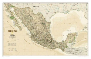
Mexico NGS Executive Wall Map ENCAPSULATED Stanfords
£17.99
Archived Product

Canada NGS Executive Wall Map ENCAPSULATED Stanfords
£20.99
Archived Product

China NGS Executive Wall Map ENCAPSULATED Stanfords
£17.99
Archived Product
North America NGS Executive Wall Map ENCAPSULATED Stanfords
£16.99
Archived Product
Mexico NGS Executive Style Wall Map ENCAPSULATED Stanfords
£19.95
Archived Product
Spain And Portugal NGS Executive Wall Map ENCAPSULATED Stanfords
£17.99
Archived Product
China NGS Executive Style Wall Map ENCAPSULATED Stanfords
£19.95
Vouchers
No voucher codes found.
Do you know a voucher code for this product or supplier? Add it to Insights for others to use.
Do you know a voucher code for this product or supplier? Add it to Insights for others to use.
 Denmark