More From Contributor

£14.99
Paper version of the standard size, 112 x 76cm (44” x 30” approx), Pacific centred political map of the world in the NGS Executive series which offers current information presented in elegant antique style. Countries are in rich but muted colours & oceans in beige, with additional panels & framing in shades of brown. An unusual feature of this series is the excellent presentation of the ocean floor, with impressive relief shading to show the continental shelf around the land masses & numerous ridges, many with names. Unfortunately, although clear & very effective on all the sizes of this design, the samples presented here cannot do full justice to such fine detail. On l&, the map has relief shading with names of main mountain ranges. Heights for peaks are given in feet. Within USA boundaries & names of states are shown. Four insets present the Arctic & the Antarctic, plus vegetation/land use & population density world maps. Also provided are lists of 10 largest countries by area & by populations. Projection is Winkel Tripel, which reduces distortion of land masses as they near the poles.NGS Executive Style World Maps are published in three

Sizes:
standard (116.5 x 77.5cm / 46” x 30” approx), enlarged (185 x 122cm / 73” x 48” approx) & a 3-sheet set (296 x 193cm / 9ft 8” x 6ft 4” approx)
- TO SEE ALL THE OPTIONS PLEASE CLICK ON THE SERIES LINK.


...
Archived Product
£20.99
Encapsulated version of the standard size, 116.5 x 77.5cm (46” x 30” approx.), Atlantic centred NGS Executive political map of the world which offers current information presented in elegant antique style. Countries are in rich but muted colours & oceans in beige, with additional panels & framing in shades of brown. An unusual feature of this series is the excellent presentation of the ocean floor, with impressive relief shading to show the continental shelf around the land masses & numerous ridges, many with names. Unfortunately, although clear & very effective on all the sizes of this design, the samples presented here cannot do full justice to such fine detail. On l&, the map has relief shading with names of main mountain ranges. Heights for peaks are given in feet. Within USA boundaries & names of states are shown. Four insets present the Arctic & the Antarctic, plus vegetation/land use & population density world maps. Also provided are lists of 10 largest countries by area & by populations. Projection is Winkel Tripel, which reduces distortion of land masses as they near the poles.NGS Executive Style World Maps are published in three

Sizes:
standard (116.5 x 77.5cm / 46” x 30” approx), enlarged (185 x 122cm / 73” x 48” approx) & a 3-sheet set (296 x 193cm / 9ft 8” x 6ft 4” approx)
- TO SEE ALL THE OPTIONS PLEASE CLICK ON THE SERIES LINK.LAMINATED & ENCAPSULATED WALL MAPS:- LAMINATED wall maps have a thin layer of plastic usually applied to the printed side only. They can be written on with suitable marker pens without any damage to the map but, unless they have been laminated on both sides, they are not damp-proof.- ENCAPSULATED wall maps are sealed between two sheets of plastic. They are more rigid & heavier than laminated maps of the same size. They are damp-proof & do not crinkle in humid conditions. Encapsulation gives the map a shiny surface, similar to being displayed behind glass.- PLEASE NOTE: many publishers & retailers often use these two terms interchangeably. Our map titles & descriptions follow the definitions provided above.


...
Archived Product
£49.99
Enlapsulated version of the enlarged size, 185 x 122cm (73” x 48” approx), Atlantic centred NGS Executive political map of the world which offers current information presented in elegant antique style. Countries are in rich but muted colours & oceans in beige, with additional panels & framing in shades of brown. An unusual feature of this series is the excellent presentation of the ocean floor, with impressive relief shading to show the continental shelf around the land masses & numerous ridges, many with names. Unfortunately, although clear & very effective on all the sizes of this design, the samples presented here cannot do full justice to such fine detail. On l&, the map has relief shading with names of main mountain ranges. Heights for peaks are given in feet. Within USA boundaries & names of states are shown. Four insets present the Arctic & the Antarctic, plus vegetation/land use & population density world maps. Also provided are lists of 10 largest countries by area & by populations. Projection is Winkel Tripel, which reduces distortion of land masses as they near the poles.NGS Executive Style World Maps are published in three

Sizes:
standard (116.5 x 77.5cm / 46” x 30” approx), enlarged (185 x 122cm / 73” x 48” approx) & a 3-sheet set (296 x 193cm / 9ft 8” x 6ft 4” approx)
- TO SEE ALL THE OPTIONS PLEASE CLICK ON THE SERIES LINK.LAMINATED & ENCAPSULATED WALL MAPS:- LAMINATED wall maps have a thin layer of plastic usually applied to the printed side only. They can be written on with suitable marker pens without any damage to the map but, unless they have been laminated on both sides, they are not damp-proof.- ENCAPSULATED wall maps are sealed between two sheets of plastic. They are more rigid & heavier than laminated maps of the same size. They are damp-proof & do not crinkle in humid conditions. Encapsulation gives the map a shiny surface, similar to being displayed behind glass.- PLEASE NOTE: many publishers & retailers often use these two terms interchangeably. Our map titles & descriptions follow the definitions provided above.


...
Archived Product
£29.99
Paper version of the enlarged size, 185 x 122cm (73” x 48” approx), Atlantic centred NGS Executive political map of the world which offers current information presented in elegant antique style. Countries are in rich but muted colours & oceans in beige, with additional panels & framing in shades of brown. An unusual feature of this series is the excellent presentation of the ocean floor, with impressive relief shading to show the continental shelf around the land masses & numerous ridges, many with names. Unfortunately, although clear & very effective on all the sizes of this design, the samples presented here cannot do full justice to such fine detail. On l&, the map has relief shading with names of main mountain ranges. Heights for peaks are given in feet. Within USA boundaries & names of states are shown. Four insets present the Arctic & the Antarctic, plus vegetation/land use & population density world maps. Also provided are lists of 10 largest countries by area & by populations. Projection is Winkel Tripel, which reduces distortion of land masses as they near the poles.NGS Executive Style World Maps are published in three

Sizes:
standard (116.5 x 77.5cm / 46” x 30” approx), enlarged (185 x 122cm / 73” x 48” approx) & a 3-sheet set (296 x 193cm / 9ft 8” x 6ft 4” approx)
- TO SEE ALL THE OPTIONS PLEASE CLICK ON THE SERIES LINK.


...
Archived Product
£20.99
The Physical World wall map from the National Geographic Society, size 92 x 61cm (36” x 24” approx), encapsulated version, designed to show not only the physical features of the land masses but also to provide a superb representation of the ocean floor. Altitude colouring & subtle but effective relief shading are used to show the topography of the land masses, with plenty of names of mountain ranges, plateaux, deserts, plains, etc. Also marked are the sources of important rivers such as the Amazon, the Nile or the Volga. No country names or boundaries are indicated & only selected major cities are marked. The sea floor is drawn with great skill to achieve a 3-D effect; continental shelves, trenches, ridges & fractures, plains, basins, etc, are shown with their names. Elevation on land is given in feet only, soundings are in metres. The map has latitude & longitude lines drawn at 10° intervals. Projection is Winkel Tripel. The two Polar Regions are presented as insets in the top corners, while at the bottom are maps of the world showing the tectonic plates & locations of major earthquakes, plus the world’s climatic zones & ocean currents. This title is also available on paper without the encapsulation.LAMINATED & ENCAPSULATED WALL MAPS:- LAMINATED wall maps have a thin layer of plastic usually applied to the printed side only. They can be written on with suitable marker pens without any damage to the map but, unless laminated on both sides, they are not damp-proof.- ENCAPSULATED wall maps are sealed between two sheets of plastic. They are more rigid & heavier than laminated maps of the same size. They are damp-proof & do not crinkle in humid conditions. Encapsulation gives the map a shiny surface, similar to being displayed behind glass.- PLEASE NOTE: many publishers & retailers often use these two terms interchangeably. Our map titles & descriptions follow the definitions provided above. ...
Archived Product
£3.50
Neuville-Vitasse
- Bullecourt (57B SW) in a series of British Army trench maps from the WWI, reproduced by G.H. Smith & Son at
...
Archived Product
£3.50
Nieuport (12 SW 1
- ed. 3A) in a series of British Army trench maps from the WWI, reproduced by G.H. Smith & Son at Approx. 7/10th
...
Archived Product
£15.99
Netherlands in the Blue Guides series focuses primarily on cultural tourism for the visitor who wishes to understand more of what they might see &, as such, the title provides thorough & objective reference information covering art, history & architecture. The guide features illustrations aimed to inform rather than just decorate, such as maps, diagrams, floor plans, architectural details & photographs. Cross referenced indexing means information is accessible & layout navigable. Selective listings of restaurants & accommodation are chosen in the belief that good, practical recommendations will contribute to the enjoyment of good art & culture. ...
Archived Product
£23.99
Map No. 10098, Finnbuliin in the new topographic survey of Norway at 1:50, 000 covering the country on 195 double-sided sheets & first published by Nordeca in 2011
- 2012; fully GPS compatible, indicating waymarked footpaths, campsites, tourist huts, illuminated ski runs, etc. The maps, now published by Nordeca, the successors to Statens Kartverk & its subsequent owners the Ugland Group, are printed on light, waterproof & tear-resistant synthetic paper. Each map covers an area of 62x 45 kilometres (39 x 28 miles approx.), with a 2-km overlap between the sheets. The maps have contours at 20m intervals (10m glacier contours), plus colouring & graphics to show cultivated areas, bogs, forests, etc. In addition to all the information expected of topographic mapping at this scale the maps distinguish between waymarked & unmarked footpaths & show campsites, tourist huts (serviced/self service/no supplies), country hotels & restaurants, & illuminated ski trails. The series uses EUREF89 (WGS84) datum & the maps have a 1-km UTM grid. Map legend is in Norwegian & English. Each title comes in a sturdy protective card envelope.
...
Archived Product
£6.99
Marco Polo French Riviera: the Travel Guide with Insider Tips Experience all of the Cote d` Azur`s attractions with this up-to-date, authoritative guide, complete with ` Best Of` recommendations. You`ll find the best hotels, authentic restaurants, the region`s trendiest places & night spots; get tips on shopping & what to do on a limited budget; plus plenty of ideas for travel with kids, sports & an overview of the most interesting festivals & events along the coast. Also contains: the Perfect Route, Travel Tips, Links, Blogs, Apps & more, French phrasebook & index. The Cote d` Azur is the ultimate product of the modern leisure society, a playground of the jet-setting elite, where the luxury world of the coast, with its palaces, chic harbour fronts, exotic gardens & azure sea, contrasts with the tranquillity, dramatic landscapes & remote mountain villages of the interior. Marco Polo French Riviera takes you along the coast, & through three of France`s most beautiful departements: Alpes-Maritimes, Var & Alpes-de-Haute-Provence. This practical pocket-sized guide visits all the classic destinations between Toulon & Menton. The ` Perfect Route` takes you to the most idyllic stretches of coast as well as the most beautiful villages & the best natural scenery inl&. The Best Of pages highlight some unique aspects of the Cote d` Azur, recommend things to do for free, & have tips for rainy days & where you can relax & unwind. Discover What`s Hot on the coast, whether glamping (camping in style) or tea mania, which has really established itself in this country of coffee drinkers. The Insider Tips reveal where flower petals are crystallised & turned into sweets & where in Nice you can immerse yourself in the art of Yves Klein. The Trips & Tours take you to the `land of perfume` around Grasse, to wild gorges & mountain villages in breathtaking locations. The Dos & Don`ts explain why your swimming trunks might cause you problems in St Tropez & why you should keep your hands off those beautifully h&-painted olive oil bottles. Marco Polo French Riviera provides comprehensive coverage of the region, including Monaco. To help you get around there`s a detailed road atlas inside, city maps of Cannes & Nice in the back cover, plus a handy pull-out map. Don`t go on holiday without a Marco Polo guide! ...
Archived Product

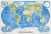
World NGS Physical Wall Map POSTER-SIZE PAPER

The Physical World wall map from the National Geographic Society, size 92 x 61cm (36” x 24” approx), paper version, designed to show not only the physical features of the land masses but also to provide a superb representation of the ocean floor.Altitude colouring and subtle but effective relief shading are used to show the topography of the land masses, with plenty of names of mountain ranges, plateaux, deserts, plains, etc. Also marked are the sources of important rivers such as the Amazon, the Nile or the Volga. No country names or boundaries are indicated and only selected major cities are marked.The sea floor is drawn with great skill to achieve a 3-D effect; continental shelves, trenches, ridges and fractures, plains, basins, etc, are shown with their
names.Elevation on land is given in feet only, soundings are in metres. The map has latitude and longitude lines drawn at 10° intervals. Projection is Winkel Tripel.The two Polar Regions are presented as insets in the top corners, while at the bottom are maps of the world showing the tectonic plates and locations of major earthquakes, plus the world’s climatic zones and ocean currents.This title is also available encapsulated.
RIP - This product is no longer available on our network. It was last seen on 25.09.2019

This page now acts as a permanent archive for this product. Add more information using the comments box below to ensure it can still be found by future generations.

Use our search facility to see if it is available from an alternative contributor.
  • Availability: Out Of Stock
  • Supplier: Stanfords
  • SKU: 9781597754460
Availability: In Stock
£12.99

Product Description

The Physical World wall map from the National Geographic Society, size 92 x 61cm (36” x 24” approx), paper version, designed to show not only the physical features of the land masses but also to provide a superb representation of the ocean floor. Altitude colouring & subtle but effective relief shading are used to show the topography of the land masses, with plenty of names of mountain ranges, plateaux, deserts, plains, etc. Also marked are the sources of important rivers such as the Amazon, the Nile or the Volga. No country names or boundaries are indicated & only selected major cities are marked. The sea floor is drawn with great skill to achieve a 3-D effect; continental shelves, trenches, ridges & fractures, plains, basins, etc, are shown with their names. Elevation on land is given in feet only, soundings are in metres. The map has latitude & longitude lines drawn at 10° intervals. Projection is Winkel Tripel. The two Polar Regions are presented as insets in the top corners, while at the bottom are maps of the world showing the tectonic plates & locations of major earthquakes, plus the world’s climatic zones & ocean currents. This title is also available encapsulated.

Reviews/Comments

Add New

Intelligent Comparison

Oooops!
We couldn't find anything!
Perhaps this product's unique.... Or perhaps we are still looking for comparisons!
Click to bump this page and we'll hurry up.

Price History

Vouchers

No voucher codes found.
Do you know a voucher code for this product or supplier? Add it to Insights for others to use.

Facebook

Jargon Buster

Paper - A thin sheet mainly used for writing. Available in a variety of colours. Made mainly from wood pulp.
Metres - A unit of measure, one metre equals 100 centimetres
Physical - Used to describe strength or visual properties of an item
Wall - A physical barrier between two areas
World - A physical grouping, commonly used to describe earth and everything associated with ti
Size - is the measurement of how big an object is in space.
Altitude - Something that can be quite high in relation to sea or ground level.
Poster - A printed picture used for decoration or information.
Subtle - Something that is delicate and not to harsh, can be difficult to describe.
Poster - A large picture usually used for decoration.

Supplier Information

Stanfords
Stanfords was established in 1853 and opened their iconic Covent Garden flagship store in 1901. They have become the top retailer of maps, travel books and accessories in the UK and arguably offer the largest selection of maps and travel books worldwide. Famous names such as Captain Robert Falcon Scott, Ranulph Fiennes and Michael Palin have purchased from Stanfords. They now have a shop in Bristol and both stores together with other venues operate a calendar of events including talks, book signings and exhibitions. As a specialist map retailer, the map selection is comprehensive and includes road maps, street maps and walking maps from worldwide destinations, as well as a selection of world atlases and wall maps. Books include travel guides and travel literature. Stanfords also stock globes, from miniatures made of blue marble to magnificent floor-standing globes. The website features a selection of interesting articles on travel topics.
Page Updated: 2023-11-12 20:15:36

Community Generated Product Tags

Oh No! The productWIKI community hasn't generated any tags for this product yet!
Menu