
 United Kingdom
 France
 Germany
 Netherlands
 Sweden
 USA
USA
 Italy
Italy
 Spain
Spain
More From Contributor


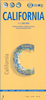

California Benchmark
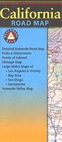
California at 1:1, 318, 821 in a series of very detailed state maps of the western states of USA from Benchmark Maps designed to highlight national/state parks or forests and other protected areas, and to provide information on recreational possibilities, campgrounds and RV parks, etc.The base map is derived from satellite imagery to show the topography, with plenty of names of individual mountain ranges, peaks, valleys, etc. Colouring is used to distinguish between various types of protected areas and land in public ownership, from BLM (Bureau of Land Management) lands to wilderness or wildlife areas. Indian Reservations and military zones are also marked. Some titles also provide additional information such as the numbering of hunting zones, etc.Road network indicates tracks
requiring high clearance or 4WD vehicles. A very wide range of symbols identifies recreational possibilities and indicates locations of campgrounds and RV parks, trailheads, various places of interest, etc. The maps have no geographical coordinates.IN THIS TITLE: the overprint for recreational facilities on this map is less extensive than on other titles in the series and no additional lists of recreational facilities are provided. Instead, the map has an index of towns/cities and counties plus enlargements at for: Los Angeles and Vicinity extending inland to San Bernardino and Moreno Valley; San Francisco Bay area from San Jose to Richmond and San Rafael in the north and inland to Antioch; San Diego and Vicinity; Sacramento; Monterey; Palm Springs area; Yosemite Valley up to the Tioga
Pass in the north; Lake Tahoe including the Nevada side with Carson City; Napa and Sonoma Valley to the Pacific Coast; and the the Redwood Coast

Product Description
Reviews/Comments
Add New
Intelligent Comparison
Archived Product

California Borch Stanfords
£9.99
Archived Product
California F&B Stanfords
£10.99
Vouchers
No voucher codes found.
Do you know a voucher code for this product or supplier? Add it to Insights for others to use.
Do you know a voucher code for this product or supplier? Add it to Insights for others to use.
 Denmark