
 United Kingdom
 France
 Germany
 Netherlands
 Sweden
 USA
USA
 Italy
Italy
 Spain
Spain
More From Contributor

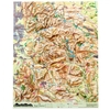


Dorrigo 3D Peak District Relief Map
A 3D map of the Peak District from Dorrigo, accurately depicts the topography including its hills, valleys, peaks, and rivers. This detailed representation helps users understand the region’s geography at a glance. Perfect for those who love the Peak District, who want to remember their favourite routes or plan their next adventure. Map measures approximately*: H 76 x W 67 cm *All measurements are approximate and should not be taken as 100% accurate. If you wish to order a frame, Ordnance Survey recommends receiving your product first to check measurements before ordering a frame for it. We cannot be held liable for incorrect measurements.

Product Description
Reviews/Comments
Add New
Intelligent Comparison
Available

Dorrigo 3D Lake District Relief Map Ordnance Survey
£62.00
Available

Ordnance Survey 3D World Relief Map Ordnance Survey
£124.99
Available
Dorrigo 3D Yorkshire Dales Relief Map Ordnance Survey
£60.00
Vouchers
No voucher codes found.
Do you know a voucher code for this product or supplier? Add it to Insights for others to use.
Do you know a voucher code for this product or supplier? Add it to Insights for others to use.
 Denmark