
 United Kingdom
 France
 Germany
 Netherlands
 Sweden
 USA
USA
 Italy
Italy
 Spain
Spain
Ordnance Survey
Website: https://shop.ordnancesurvey.co.uk/Navigate your world with confidence with Ordnance Survey (https://shop.ordnancesurvey.co.uk/)! Explore our extensive range of maps, guides, and outdoor gear designed to help you explore the great outdoors with ease. From detailed maps for hiking and cycling to innovative GPS devices, we've got everything you need to plan your next adventure. With our heritage of accuracy and reliability, Ordnance Survey is your trusted companion for exploring the UK's landscapes, whether you're a seasoned explorer or a weekend wanderer. Gear up and discover new horizons with Ordnance Survey today!
Available

-
Explore Secret
Stories Petworth's
Trees & Queens Tour,
a self-guided
interactive walking
£0.00
Available

-
Map of Galloway
Forest Park South -
OS Explorer Map 319
(Glen Trool &
Clatteringshaws Loch
£12.99
Available

-
Map of Motherwell &
Coatbridge - OS
Explorer Map 343
(Whitburn & Carluke)
Format: Folded m
£12.99
Available

-
Taunton & Lyme Regis
(inc. Chard &
Bridport) map - OS
Landranger 193
Publication Date:
16/
£16.99
Available

-
Inverness & Loch
Ness (inc.
Strathglass) map -
OS Landranger 26
Format: Folded map
Physica
£12.99
Available

-
Waterproof and
lightweight, the
Duality Mountain Cap
is constructed from
seam-taped breat
£42.50
Available

-
Reproduction map of
Nottingham from the
Revised New Edition,
1896 to 1904.
Available flat
£8.99
Available

-
This Factor 50+ sun
cream has been
developed
specifically to
protect skin from
the increas
£10.99
Available

-
3 for 2 on all socks
T&C's apply All day
comfort and
protection from
Bridgedale men's
hiki
£24.00
Available

-
The versatile
polyester Green Cone
PRS tipi has great
headroom, a large
porch and inner t
£369.99
Available

-
Map of Coigach &
Summer Isles - OS
Explorer Map 439
(Inverpolly) Format:
Folded map Physic
£16.99
Available

-
Famous for
Scotland's biggest
Ski Area, OS
Explorer Map OL 52
also includes part
of the C
£14.99
Available

-
Formerly the
Hoopie™ Collar. An
everyday collar with
an easy-to-use
side-release buckle.
O
£21.95
Available

-
Map of Newcastle
Emlyn - OS Explorer
Map 185 (Llandysul &
Cynwyl Elfed)
Format: Folded map
£12.99
Available

-
The Landranger map
of
Berwick-upon-Tweed,
including Holy
Island and Wooler is
a must-have
£16.99
Available

-
Map of Romney Marsh
- OS Explorer Map
125 (Rye &
Winchelsea Tenterden
& New Romney) Public
£12.99
Available

-
Ordnance Survey's
historical maps are
reproduced on
high-quality chart
paper and supplied
£7.19
Available

-
Reproduction map of
Penzance from the
Revised New Edition,
1896 to 1904
£7.19
Archived Product

-
Wainwright's
Coast-to-Coast Walk route
is named after Alfred
Wainwright, the
well-known author and
tireless hill-walker,
who set out to capture
the rich diversity of
landscapes in northern
England in one walk. The
190 mile route takes you
through three National
Parks and this set of
highly detailed OS
Explorer maps comprises
the nine maps that you'll
need to complete this
classic walk: OL4, OL5,
OL19, OL26, OL27,
OL30, 302, 303 and 304.
By buying all nine OS
Explorer maps together
your save 20% from normal
prices. With all maps in
this set you will receive
a code for use on your
iOS or Android smartphone
or tablet.
Availability: In Stock
£107.93
Available

-
Take away the fear of
washing insulated items
with this easy-to-use
all-in-one kit.
Containing Grangers new
concentrated Down Wash,
this eco kit contains all
you need to restore the
appearance of your down
articles so they perform
as they should and
continue to keep you warm
and dry. Washing a down
jacket is just as
essential as any other
piece of kit. Over time,
dust, sweat and oils
build up, restricting
the garment’s ability
to breathe and the down
insulation will lose its
loft, resulting in a
jacket that no longer
keeps you warm or dry. So
why not try this
all-in-one solution today
so you can stay warm
outdoors for longer. How
to look after your
outdoor clothing OS
GetOutside As you spend
time outdoors, the
technical features on
clothing can start to
wear off. Kings of kit
care, Grangers, explain
how to look care of your
outdoor clothing so you
can restore its
performance and enjoy it
for years to come.
getoutside.ordnancesurvey.co.uk
Availability: In Stock
£12.00
Available

-
The Yorkshire Dales
combine a wild limestone
landscape of high rolling
moorland gouged by
dramatic caves and
cascading waterfalls with
peaceful farmland
carpeted in wildflowers
and dotted with ruined
abbeys, ancient stone
walls and barns, and
timeless villages waiting
to be discovered. The 40
moderate walks in this
collection from award
winning publisher Pocket
Mountains highlight the
very best the area has to
offer and include
adventures in Wharfedale,
Malhamdale, Nidderdale,
Ribblesdale,
Wensleydale, Swaledale
and Dentdale. Many routes
make use of sections of
established long-distance
trails such as the
Pennine Way and the Dales
Way.
Availability: In Stock
£6.99
Archived Product

-
OS Explorer Map 226 shows
the area between
Newmarket and Ely.There
are numerous Recreational
Paths in the area
incluuding; E2 European
Long Distance Path, Fen
Rivers Way, Harcamlow
Way, Hereward Way,
Icknield Way Path, Lark
Valley Path, Ouse Valley
way and Stour Valley
Path.With this map you
will receive a code for
use on your iOS or
Android smartphone or
tablet. Find our more at
Mobile Download FAQ. The
OS Explorer map for Ely &
Newmarket is available in
both the standard paper
version and weatherproof
'Active' version.
Availability: In Stock
£14.99
Available

-
Ultralight hiking and
running poles from
Mountain King. Increase
your balance and
stability when out
exploring with the
compact, foldable,
carbon fibre trail
running and hiking poles
from Mountain King.
Reduces stress on the
legs and back so you can
get the best out of your
training sessions,
leisure, and
competitions.
Availability: In Stock
£130.99
Available

-
The Collapsible Java
Drip's clever, expanding
silicone cone brews
fresh, delicious coffee
and yet collapses to just
2.5 cm high to travel
anywhere. Simply set the
filter on top of your
favourite container,
from a wide mouth water
bottle to a small pot,
add any brand of GSI
Outdoor 4 filter,
grounds and water and
voila, eye-opening drip
coffee just like home.
The convenient cover even
doubles as a trivet for
the cone when you're done
brewing and keeps
everything clean during
transport.
Availability: In Stock
£20.00
Available

-
Map of Norfolk Coast West
- OS Explorer Map 250
(King's Lynn &
Hunstanton) Publication
Date: 16/09/2015
Availability: In Stock
£16.99
Archived Product

-
OS Explorer Map 226 shows
the area between
Newmarket and Ely.There
are numerous Recreational
Paths in the area
incluuding; E2 European
Long Distance Path, Fen
Rivers Way, Harcamlow
Way, Hereward Way,
Icknield Way Path, Lark
Valley Path, Ouse Valley
way and Stour Valley
Path.With this map you
will receive a code for
use on your iOS or
Android smartphone or
tablet. Find our more at
Mobile Download FAQ. The
OS Explorer map for Ely &
Newmarket is available in
both the standard paper
version and weatherproof
'Active' version.
Availability: In Stock
£8.99
Available

-
Beinn Dearg & Loch Broom
(inc. Ben Wyvis) map - OS
Landranger 20 Format:
Folded map Physical Size:
1000 x 890 mm (134 x 227
mm folded) Publication
Date: 24/02/2016
Availability: In Stock
£12.99
Available

-
Map of Chelmsford & The
Rodings - OS Explorer Map
183 (Maldon & Witham)
Format: Folded map
Physical Size: 1000 x 890
mm (134 x 227 mm folded)
Publication Date:
16/09/2015
Availability: In Stock
£12.99
Archived Product

-
Discover the past with a
reproduction of an
historical Ordnance
Survey map for
Caernarvon. Published
from 1896 to 1904, the
Revised New Edition for
England and Wales maps
show contours, latitude
and longitude, parish
boundaries, railways,
roads, waterways and
woods in 1 inch to 1 mile
scale. These
reproductions are printed
on high quality, 200
gram sepia toned map
paper, and are
approximately 55 x 43 cm
(21 x 17 inches), giving
an authentic look.They
are available either flat
or framed - framed
versions are reduced by
5% to fit - and are ideal
for display, reference
and research.This series
of 477 historical maps
was created to give
accurate overview mapping
for Great Britain, and
was intended for
military, government and
leisure use, including
touring and cycling. Many
of the previous edition
had become very out of
date so a new survey was
commissioned that began
in 1893, with the maps
being published as they
were completed.These maps
are the 'Outline'
versions that show
contour lines and
features in hand-drawn
black and white, and
show many of the map
symbols that we are
familiar with today. As
well as display, they
are useful for tracing
family history,
researching development
and understanding how
both natural and man-made
geography has changed
since the end of the
Victorian age.We have
maps from the 1896 to
1904 editions available
for most of Great
Britain, however, some
are missing as the
originals were destroyed
when the Ordnance Survey
was bombed during the
Second World War. This
map covers Caernarvon in
the Revised New Edition
for England and Wales.
Check the 'Area Covered'
to determine what towns
cities and features are
shown on this map.
Availability: In Stock
£47.99
Available

-
Map of Coll & Tiree - OS
Explorer Map 372 Format:
Folded map Physical Size:
1000 x 890 mm (134 x 227
mm folded) Publication
Date: 16/09/2015
Availability: In Stock
£12.99
Available

-
A minimalist glove that
provides improved grip
and blister resistance on
treks both short and
epic, the Black Diamond
Trail Gloves are light,
comfortable and highly
breathable. The four-way
stretch back panel fabric
manages moisture on warm
days, and the durable
synthetic palm makes for
secure handling of
trekking poles and other
trail essentials.
Integrated pull tabs make
for easy on and off,
while the half-finger
design adds breathability
and dexterity.
Availability: In Stock
£15.00
Available

-
Designed to let you get
changed anywhere, whilst
protecting you from the
elements, dryrobe®
Advance is an essential
piece of kit for all
outdoor activities. The
long sleeve design
enables you to get
changed quickly and
easily. The dryrobe®
Advance can be used
multiple times throughout
the day, over wet kit,
without the need for
drying between uses. Keep
doing the things you love
outdoors with the world's
warmest, most versatile
change robe.
Availability: In Stock
£160.00
Archived Product

-
Geological maps
illustrate the nature,
extent and relative age
of rock types to be found
in a district. Solid and
Drift maps show the
'solid' (bedrock) geology
and the 'drift' deposits
(such as peat and glacial
deposits) with equal
emphasis – these map
editions give the best
impression of the
underfoot geology.
Availability: In Stock
£12.00
Archived Product

-
OS Explorer Map 433 from
Gairloch to Torridon
represents some of the
most dramatic scenery in
the UK.With some serious
mountains (and 9 Munros),
there's plenty for the
adventurous, while
coastal fishing villages
provide less energetic
distractions.With this
map you will receive a
code for use on your iOS
or Android smartphone or
tablet. Find our more at
Mobile Download FAQ. The
OS Explorer map for
Torridon - Beinn Eighe &
Liathach is available in
both the standard paper
version and weatherproof
'Active' version.
Availability: In Stock
£14.99
Available

-
Okehampton & North
Dartmoor (inc. Crediton &
Bovey Tracey) map - OS
Landranger 191
Publication Date:
24/02/2016
Availability: In Stock
£16.99
Archived Product

-
OS Landranger map 84
shows Dumfries & Castle
Douglas, and also
includes Parton,
Crossmicheal, Shawhead,
Dalbeattie,
Kirkcudbright, Ringford
and part of the Galloway
Forest Park.The coast
around Solway Firth has
been designated and Area
of Outstanding Natural
Beauty.With this map you
will receive a code for
use on your iOS or
Android smartphone or
tablet. Find our more at
Mobile Download FAQ.The
OS Landranger map for
Dumfries & Castle Douglas
is available in both the
standard paper version
and weatherproof "Active"
version.
Availability: In Stock
£8.99
Archived Product

-
Geological maps
illustrate the nature,
extent and relative age
of rock types to be found
in a district. Bedrock
and Superficial Deposits
maps show the bedrock
geology and the
superficial deposits
(such as peat and glacial
deposits) with equal
emphasis – these map
editions give the best
impression of the
underfoot geology.
Availability: In Stock
£12.00
Available

-
3 for 2 on all socks
T&C's apply The ultimate
sock for serious
adventurers who enjoy
exploring the hills and
mountains, especially in
winter. The Bridgedale
Explorer Merino
Performance Boot Sock is
the perfect sock to look
after your feet so you
can get on with
exploring. When you are
out on the trail, the
last thing you need are
bad socks, the heavy
weight Merino Boot Socks
will keep your feet
wrapped in comfort on
long hike. The soft
structured sock won’t
slip down into your
walking boots and wrinkle
up under your arches
exposing your heel, so
you don’t need to spend
half your walk sorting
out your socks. Easy to
wash they will spring
back into shape after a
wash and quick dry making
them ideal for multi-day
treks or camping trips.
Availability: In Stock
£28.00
Available

-
Smart design meets peak
performance. HydraPak
developed an innovative,
new Contour™ reservoir
to be lightweight, low
profile and rugged. A 3D
bottom, Shape-Loc™
baffles and side exit
port combine to provide
superior fit and
performance in the widest
variety of packs for
extended backpacking and
hiking adventures.
Availability: In Stock
£47.50
Archived Product

-
Sheet Explanations are
booklets written to
accompany the BGS 1:50
000 scale geological
maps. They describe the
geology of the map sheet
area, offering
interpretations of the
geological history of the
area, the more recent
landscape-forming events
and economic geological
information. They are
full colour A5 booklets.
Availability: In Stock
£9.00
Available

-
Whether wearing them on
their own or layering
underneath a burlier
glove, a pair of the
Waterproof Liners will
always find a place on
your packing list. The
first of their kind, the
Waterproof Liners are
complete with must-have
details like
touchscreen-compatible
fingertips, a pull-on
loop, and silicone grip
palm and fingers. Rest
assured, you'll want to
have these liners in your
emergency kit when the
weather forecast is
taking a turn for the
worse. Key Features:
WaterproofBreathable
Windproof Lightweight
Touchscreen Compatible
Anti-Slip Silicone Pads
on Palm and Finger
Tapered Wrist
Availability: In Stock
£42.50
Available

-
Reproduction map of North
London from the Revised
New Edition, 1896 to
1904. Available flat
(rolled) or framed.
Availability: In Stock
£8.99
Available

-
Stay in touch with this
handy two-way global
satellite communicator
with interactive SOS
capabilities just in case
of an emergency. Contact
your friends and family
by text even where mobile
phones cannot reach for
peace of mind when you
are exploring. Share your
location or make an SOS
call the Garmin inReach
Messenger is an essential
safety device for travel
anywhere.
Availability: In Stock
£223.99
Available

-
Latest generation of
wearable GPS from Garmin,
the Fenix 6 Pro (47mm)
has a multitude of
activity options, built
in heart rate monitoring,
music playback and much
more.
Availability: In Stock
£549.99
Available

-
Keep your phone safe from
water and dust whatever
the weather or climate.
Aquapac’s waterproof
phone case is the
original professional
waterproof phone case,
trusted since 1983. You
can use most of the
features on your phone
while protecting it from
the elements and your
phone is kept safe even
if you drop it in the
water while securely
locked in the waterproof
pouch.
Availability: In Stock
£19.99
Archived Product

-
The GPSMAP® 64st has all
the features of the
GPSMAP 64, with the
added inclusion of a
barometric altimeter,
3-axis compass, wireless
connectivity and 8GB
internal memory. LAST FEW
REMAINING The new GPSMAP
64st handheld navigator
features a brilliant
2.6” sunlight-readable
screen, a
high-sensitivity GPS and
GLONASS receiver with a
quad helix antenna for
faster satellite fix and
superior reception. Water
resistant and rugged,
the GPSMAP 64st comes
with barometric
altimeter, 3-axis
compass, an outdoor
optimised dual battery
system and a preloaded
European REC MAP 100k on
8GB internal memory. It
stays connected
wirelessly to Garmin
sensors via ANT+ and to
your smart phone through
Bluetooth. The device
lasts up to 16 hours on
one charge, and the
comprehensive features it
includes guarantee safe
navigation off the beaten
track. Please note that
batteries are not
included with this unit.
Exclusive OS Offer Get a
free 12 month OS Maps
subscription worth
£25.99 with this device.
Plan routes, export to
GPS and print paper maps
at home. A subscription
code will be emailed to
you within five working
days of purchase.
Availability: In Stock
£269.99
Available

-
Purchase the Ashford
folded map: single-sided
(boarded cover) from the
OS Explorer Map range
Publication Date:
16/09/2015
Availability: In Stock
£16.99
Available

-
Designed for tagging
summits and scrambling in
the high alpine, the
Women’s Pursuit 15 Pack
carries everything you
need for a day of light
and fast mountain travel.
With a harness design
inspired by our Distance
series, Black Diamond's
Pursuit Daypacks are
built with a custom “BD
Continuous Fit Harness”
with a seamless
“wing” body
construction that
contours to the body for
maximum comfort on the
move. A women’s
specific fit in the
shoulders, chest, and
hips ensures all-day
comfort. The quick pull
compression system
adjusts depending on your
load. With quick access
side pockets and easy
access trekking pole
storage, snacking and
stashing is easy on the
move. Black Diamond's
Pursuit Daypacks are made
from 100% recycled body
fabrics with a breathable
back panel. The pack
includes an external
hydration storage pocket.
Availability: In Stock
£102.00
Available

-
Pay in 3 interest-free
payments - select PayPal
in checkout. 18+, terms
apply. Learn more. When
excellence is your goal,
you need the top
performance and
reliability that the
Suunto Vertical All Black
GPS Watch can give you
Created to be the perfect
companion for your
outdoor training
sessions, multiday trips
or camping and
competitions with
extra-long battery life
and superb GPS accuracy
and connectivity. This is
the fitness tracker watch
you can trust.
Availability: In Stock
£545.00
Archived Product

-
Sheet Explanations are
booklets written to
accompany the BGS 1:50
000 scale geological
maps. They describe the
geology of the map sheet
area, offering
interpretations of the
geological history of the
area, the more recent
landscape-forming events
and economic geological
information. They are
full colour A5 booklets.
Availability: In Stock
£9.00
Archived Product

-
London was originally
located at a
crossing-point on the
Thames in an area of dry
land where sand and
gravel banks were
surrounded by boggy
marshland. This book
describes the rocks and
soils underlying London,
how the came to be there
and how they impinge on
the lives of those who
live and work in the
City, providing a
geological history of the
past 500 million years.
Availability: In Stock
£24.00
Archived Product

-
Sheet Explanations are
booklets written to
accompany the BGS 1:50
000 scale geological
maps. They describe the
geology of the map sheet
area, offering
interpretations of the
geological history of the
area, the more recent
landscape-forming events
and economic geological
information. They are
full colour A5 booklets.
Availability: In Stock
£9.00
Available

-
Combining PrimaLoft®
GOLD insulation,
PERTEX® outer fabric and
a brushed microfleece
lining is the
revolutionary formula of
the ultra lightweight,
super packable and
extremely warm Prism
Glove. Packed into their
own stuff sack they will
go unnoticed in your
pack, put them on and
their remarkable warmth
to weight ratio makes
them ideal for any fast
and light activity.
Availability: In Stock
£50.00
Archived Product

-
Sheet Explanations are
booklets written to
accompany the BGS 1:50
000 scale geological
maps. They describe the
geology of the map sheet
area, offering
interpretations of the
geological history of the
area, the more recent
landscape-forming events
and economic geological
information. They are
full colour A5 booklets.
Availability: In Stock
£9.00
Available

-
Get power from the sun
with this portable solar
panel from Goal Zero.
Take this tough but
lightweight solar panel
anywhere so you can
charge your devices on
the go. In just a few
hours of sun, this panel
is ready to charge your
phone, camera or other
small USB electronic
devices so you can stay
out and stay active for
longer.
Availability: In Stock
£59.99
Available

-
Curbar Edge woven patch,
celebrating this
gritstone escarpment and
popular rock climbing
location above the
village of Curbar in the
Peak District. Perfect
for celebrating your
favourite places and
adventures in the Peak
District, designed with
a 'pub sign' feel to this
range of patches,
inspired by the
traditional wooden name
signs that hang above the
many old country pubs and
inns in this part of
England. Get 3 for 2 on
all patches. Cheapest
item free. Discount
automatically applied in
the checkout. Excludes
sale.
Availability: In Stock
£5.00
Available

-
Wander off the beaten
track to uncover the
world's most secret
destinations through
insightful text and
beautiful hand-drawn
illustrations: discover
an ancient gateway to the
Mayan underworld, a
mysterious underwater
monument sunken off the
Ryukyu Islands in Japan
or a prehistoric village
covered for centuries by
a huge sand dune in the
Orkney Islands. In
Inspired Traveller's
Guides: Hidden Places
travel journalist Sarah
Baxter's evocative words
instantly transport you
to 25 of the world's most
obscured places. From
remote locations that
visitors must trek and
wade just to catch a
glimpse of, to forgotten
cities only recently
revealed and places
purposefully hidden as
sanctuaries from
persecution, each
destination has a very
human story at its heart.
Featured locations:
Tyneham, Dorset,
England Skara Brae,
Orkney, Scotland Menlo
Castle, Galway, Ireland
Ladby Ship, Kerteminde,
Denmark Our Dear Lord in
the Attic, Amsterdam,
Netherlands Montsegur,
France Kaisertal,
Austria Black Forest,
Germany Rok Runestone,
OEdeshoeg, Sweden Villa
of Tiberius, Sperlonga,
Italy Bulnes, Cabrales,
Spain Lalibela, Ethiopia
Great Zimbabwe, Zimbabwe
Turpan Oasis, Turpan,
China Phnom Kulen, Siem
Reap Province, Cambodia
Yonaguni, Yaeyama
Islands, Japan Mount
Borradaile, Arnhem Land,
Australia Curio Bay,
Southland, New Zealand
Spirit Island, Alberta,
Canada The Green Mill,
Chicago, USA Havasu
Canyon, Arizona, USA
Plymouth Church of the
Pilgrims, New York, USA
Actun Tunichil, Belize
Choquequirao, Peru El
Mirador, El Peten,
Guatemala Savour a moment
to delight in the
serenity and seclusion of
the secret escapes
collected in this
beautifully illustrated
guide, full of surprise,
wonder and sights
otherwise unseen. About
the author Sarah Baxter
is a writer, book author
and editor specialising
in travel, adventure,
history and the great
outdoors. In the name of
exploration, she's
climbed Kilimanjaro,
snorkelled with killer
whales, eaten sheep's
brain, walked on the
wings of a bi-plane,
descended into an
Icelandic volcano,
learned to salsa in
Barcelona and much, much
more. Formerly deputy
editor at Wanderlust
travel magazine, she now
writes for a range of
outlets including The
Telegraph, The
Independent, iPaper,
Wanderlust, Sunday Times
Travel magazine, Country
Walking and others. She
has also authored many
books, including A
History of the World in
500 Walks, The Inspired
Traveller's Guide to
Spiritual Places and
Lonely Planet's Where to
Go When.
Availability: In Stock
£12.74
Archived Product

-
Dryrobe combines their
unique synthetic
lambswool inner with the
waterproof and
wind-resistant outer
layer used on the
dryrobe® Advance, to
offer quality protection
from the elements for
your furry friend. More
than the average dog coat
or jacket, the dryrobe®
dog coat is one tough bit
of kit. It's designed to
stand the wear and tear
of even the most active
dog. The perfect
combination of both a dog
towel, coat and drying
robe, it is the ultimate
adventure companion for
your best friend. With 4
sizes available and
adjustable straps, there
is a dryrobe® to fit
most dogs, so they can
stay warm and dry in wet
and cold conditions. And
because we know that
detail matters,
dryrobe® Dog’s
reflective piping helps
make your canine partner
more visible, whatever
the weather.
Availability: In Stock
£40.00
Available

-
Made with a soft and
naturally moisture
wicking merino blend,
the Hiking Beanie from
the legendary Tilley is
extremely lightweight and
breathable, meaning it
can be worn from autumn
to spring. This is the
grey version - other
colours are available.
Availability: In Stock
£20.00
Available

-
The Trail Blaze poles are
made aluminium alloy,
making them a great light
weight choice for both
trail running and
hiking.It has a hard
wearing tungsten carbide
wear tip, comfortable
grip and a mesh storage
bag for when not in use.
The poles come with
trekking baskets for use
in muddy conditions and
light snow. The poles are
collapsible 4 section and
fixed length when
assembled. They are quick
to open/close and fit
most race vests or stow
away neatly in your
rucksack.
Availability: In Stock
£97.00
Available

-
This is the only bear
your feet will want to
encounter when you’re
exploring the great
outdoors. A lightly
cushioned hiking sock
with all the anti-funk
qualities of Merino Wool,
the Bear Town gives you
freedom and flex to hike
your way out of any
unexpected encounter on
the trail. Women's micro
crew socks average 19 cm
from heel to cuff -
expect them to show about
12.5 cm above a low
hiking shoe or just above
a standard hiking boot.
The cushion sock features
terry loops under the
foot, and in the taller
styles reaches above the
ankle for comfort and
protection. A performance
fit means no slipping,
no bunching, no blisters
for peak hiking comfort.
Every toe seam using Darn
Tough's True Seamless™
Toe technology for an
ultra smooth,
undetectable feel.
Reinforced footbed and
Achilles cushion improves
comfort and helps them
last longer. Merino Wool
is at home on the trail,
naturally moving moisture
to keep feet fresh and
dry in all weather.
Lightweight socks breathe
naturally and deliver
flexible, all-day
comfort for summer
hiking. Made in Vermont,
USA. Unconditionally
Guaranteed for Life - if
these aren’t the
longest lasting socks
you’ve ever owned,
return them for another
pair.
Availability: In Stock
£22.00
Available

-
Ruff and Tumble’s
Drying Coat dries your
dog in minutes and takes
the hassle out of
managing wet dogs.
Imagine a car that
isn’t mud splattered
and whiffy, or a kitchen
without a heap of smelly,
damp towels. Simply slip
a Ruff and Tumble Drying
Coat over your wet dog,
fasten around the belly
and neck with easy-to-use
Velcro, and your job is
done. The drying robe
dries a dog quicker than
you can and does all the
work for you. Two layers
of absorbent towelling
wick away wet from your
dog, and the soft cotton
is comfortable and cosy
for them to wear. No
shivering in the back of
the car, no wet dog
smells, and no endless
rubbing down. The Ruff
and Tumble Drying Coat is
a double winner, for you
and your dog.
Availability: In Stock
£59.95
Available
-
Vango's award-winning
Nitestar sleeping bag
contains our Alpha
insulation, combining
excellent warmth
properties with
much-improved
compressibility, it is
smaller and lighter than
ever before. Perfect for
youth groups or your
spring and summer
adventures.
Availability: In Stock
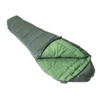
£40.00
Available

-
3 for 2 on all socks
T&C's apply This is the
only bear your feet will
want to encounter when
you’re exploring the
great outdoors. A lightly
cushioned hiking sock
with all the anti-funk
qualities of Merino Wool,
the Bear Town gives you
freedom and flex to hike
your way out of any
unexpected encounter on
the trail. Women's micro
crew socks average 19 cm
from heel to cuff -
expect them to show about
12.5 cm above a low
hiking shoe or just above
a standard hiking boot.
The cushion sock features
terry loops under the
foot, and in the taller
styles reaches above the
ankle for comfort and
protection. A performance
fit means no slipping,
no bunching, no blisters
for peak hiking comfort.
Every toe seam using Darn
Tough's True Seamless™
Toe technology for an
ultra smooth,
undetectable feel.
Reinforced footbed and
Achilles cushion improves
comfort and helps them
last longer. Merino Wool
is at home on the trail,
naturally moving moisture
to keep feet fresh and
dry in all weather.
Lightweight socks breathe
naturally and deliver
flexible, all-day
comfort for summer
hiking. Made in Vermont,
USA. Unconditionally
Guaranteed for Life - if
these aren’t the
longest lasting socks
you’ve ever owned,
return them for another
pair.
Availability: In Stock
£27.00
Available

-
Map of Manchester &
Salford - OS Explorer Map
277 (Oldham, Rochdale &
Stockport) Publication
Date: 16/09/2015
Availability: In Stock
£12.99
Available

-
Denbigh & Colwyn Bay map
- OS Landranger 116
Publication Date:
24/02/2016
Availability: In Stock
£16.99
Available

-
Map of Central Lewis &
Stornoway - OS Explorer
Map 459 (Eye Peninsula &
Callanish) Format: Folded
map Physical Size: 1000 x
890 mm (134 x 227 mm
folded) Publication Date:
16/09/2015
Availability: In Stock
£12.99
Available

-
Cambridge & Newmarket
(inc. Saffron Walden) map
- OS Landranger 154
Format: Folded map
Physical Size: 1000 x 890
mm (134 x 227 mm folded)
Publication Date:
07/03/2022
Availability: In Stock
£12.99
Archived Product

-
This traditional throwing
game has probably been
around in one or or
another for centuries,
but only appeared as a
game with defined rules
in the later 1800s.
Players take it in turns
to try and throw the rope
ring quoits over the
pegs, with the highest
total score winning the
round. It's a great
family game for parties
or social gatherings,
and can be played out
doors or (carefully!)
indoors, by all ages
This quoits set by
Traditional Garden Games
comes in a quality canvas
storage bag with four
rope rings, a
traditional quoit base
and removable screw in
scoring stakes. It's easy
to transport, and only
needs limited space, so
is a great game option
for trips to the beach,
camping or visits to the
park.
Availability: In Stock
£12.79
Available

-
3 for 2 on all socks
T&C's apply Protect your
feet with Bridgedale
women's hiking boot socks
so your feet will be dry
and comfortable all day.
The Merino wool blend
sock will keep your feet
warm and dry whether you
are walking the dog,
backpacking or trekking.
A close fit without
constriction for whole
foot support in a sock
that you can wear the leg
cuff pulled up or down
and won’t wander down
into your boots or
irritate your toes. Easy
to wash and fast drying
which is great when you
are camping or on treks
for several days.
Availability: In Stock
£24.00
Available

-
The Hydro Plane floating,
flying disc dog toy is
easy to throw and
retrieve on land or on
the water you and your
dog can make up great
games to play together.
Easy to carry on your
walk or pack to take with
you on trips you can play
with your dog on land,
in snow or in the water
as the Hydro Plane toy
will easily float on the
water surface.
Availability: In Stock
£30.95
Available

-
Made with a soft and
naturally moisture
wicking merino blend,
the Hiking Beanie from
the legendary Tilley is
extremely lightweight and
breathable, meaning it
can be worn from autumn
to spring.
Availability: In Stock
£20.00
Available

-
High Street patch,
celebrating one of the
best-loved fells in the
English Lake District.
Whether you're a serious
Wainwright bagger or more
casual fell walker, mark
your hill walking
achievements and treat
yourself (or a hill
buddy) to one of these
retro patches, inspired
by vintage beer pump
clips. Perfect for adding
a bit of character to
your pack or displaying
at home as a reminder of
great days in the hills.
Get 3 for 2 on all
patches. Cheapest item
free. Discount
automatically applied in
the checkout. Excludes
sale.
Availability: In Stock
£5.00
Available

-
3 for 2 on all socks
T&C's apply Protect your
feet with Bridgedale
women's hiking boot socks
so your feet will be dry
and comfortable all day.
The Merino wool blend
sock will keep your feet
warm and dry whether you
are walking the dog,
backpacking or trekking.
A close fit without
constriction for whole
foot support in a sock
that you can wear the leg
cuff pulled up or down
and won’t wander down
into your boots or
irritate your toes. Easy
to wash and fast drying
which is great when you
are camping or on treks
for several days.
Availability: In Stock
£24.00
Available

-
A minimalist glove that
provides improved grip
and blister resistance on
treks both short and
epic, the Black Diamond
Trail Gloves are light,
comfortable and highly
breathable. The four-way
stretch backpanel fabric
manages moisture on warm
days, and the durable
synthetic palm makes for
secure handling of
trekking poles and other
trail essentials.
Integrated pull tabs make
for easy on and off,
while the half-finger
design adds breathability
and dexterity.
Availability: In Stock
£18.00
Archived Product

-
Using Old Series OS maps
from a survey first
published in 1805, these
old maps can be
downloaded from
Memory-Maps website and
then viewed using leading
edge V5 Memory-Map
software. Self select
1600km2 from England and
Wales, historic survey
cal...
Availability: In Stock
£16.67
Archived Product

-
Explore Secret Stories
Honor Oak: Angels &
Elephants Tour, a
self-guided interactive
walking tour to enjoy
whenever you want. This
tour is part of an
Ordnance Survey series of
bite-sized,
tongue-in-cheek stories
for you to read out loud.
Expect nutty nature,
smelly smugglers,
raucous royals you get
the idea. Are you ready
to discover some of the
deep secrets and quirky
things in this corner of
Southeast London? On this
tour, you’ll uncover
the whereabouts of the
submerged River Peck and
a royal oak tree. Explore
how the old industrial
buildings have been
transformed into fun new
locations and how the
Surrey Canal has been
extensively landscaped to
become an oasis in the
heart of Peckham. See
plenty of hills, a large
teeming lake and the
recently regenerated
Elephant Park Total
length: 5.2 miles;
Suggested age range: 7+
Purchase this Tour (and
more) in the Secret
Stories App, available
for free download from
Android Play and Apple
App store. You'll find
more details of the tour
and what it contains in
the app!
Availability: In Stock
£3.99
Archived Product

-
Using the Popular Edition
OS maps from a survey
first published in 1919,
these old maps can be
downloaded from
Memory-Maps website and
viewed using leading edge
V5 Memory-Map software.
Self select 1600km2 from
England and Wales,
historic survey...
Availability: In Stock
£16.67
Available

-
A reusable and
lightweight thermal
blanket for one or two
people that reflects and
retains 90% of radiated
body heat and reduces
windchill. Highly visible
and radar reflective for
search and rescue teams,
this flexible and compact
strong blanket is also
made from tear-resistant
material.
Availability: In Stock
£7.99
Available

-
The Highlands Sleeping
Bag for dogs is the ideal
portable dog bed for
camping and travel. No
one wants to sleep with a
wet, dirty dog or one
that cannot find a place
to sleep comfortably in
the tent, that way no
one gets a good night’s
sleep. The Highlands Dog
Sleeping Bag will give
your dog their own space
whenever they want to
take a nap and keep them
happy. The cosy sleeping
bag will help to provide
your best friend with
their own bed while also
allowing you to sleep
close by. Your dog can
sleep with the bag open
or closed to supply a
comfortable, warm space
in whatever position they
prefer to sleep, helping
to keep your camping
equipment safer and
cleaner.
Availability: In Stock
£125.95
Available

-
This high-performance
flying disc is ideal for
fetch sessions on both
water and land. The Hover
Craft™ is built with a
moulded foam core that
tracks true for
long-distance tosses and
floats on water. The
construction is soft on
teeth and gums yet
structured enough to
maintain shape over time.
Bright colours and
reflective trim enhance
visibility in the water
and low-light conditions.
Availability: In Stock
£25.95
Available

-
Tug, throw, fetch,
repeat: The Huck-a-Cone
was inspired by rewarding
play between avalanche
dogs and handlers during
training. We took our
popular Gnawt-a-Cone™
and added a knotted rope
handle, providing
excellent grip during
training drills and
rewarding play. The
natural sustainable
rubber toy is tough
enough for even the most
persistent canines. Our
toys are designed to be
interactive – it's just
more fun that way. While
our toys suit a range of
play styles, dogs can be
crafty and determined
chewers, so supervised
play is recommended. If
any part of the toy
becomes loose or
detached, take the toy
away and discard.
Availability: In Stock
£17.95
Available

-
For the dog whose passion
for fetch knows no
bounds, the pontoon-like
Hydro Plane floats high
on snow and water alike
for year-round
performance. Dogs
learning to fetch can
build confidence with the
soft construction. The
oversized-ring design is
easy to pick up and may
even inspire a game of
tug, making it great for
training and exercising
and an all-around good
time.
Availability: In Stock
£25.95
Available

-
If your dog loves to play
chase, the Huckama dog
toy is a wonderful
interactive toy for
training and exercise
which helps give your dog
a playtime challenge and
keeps their mind active
as well as their body.
Much more fun than a
tennis ball the Huckama
is easy to play throw and
chase games as this dog
toy moves like a small
animal when rolled and
bounces unpredictably to
keep your dog guessing
where it will go next.
The Huckama is also a dog
treat toy dispensing
small dog treats you have
stuffed in it when your
dog plays with their toy.
Availability: In Stock
£23.95
Available

-
Your dog loves spending
time with you, the
Huck-a-Cone dog toy is an
excellent interactive dog
toy for training and
exercise to keep your dog
happy and healthy. Easy
to grasp and throw rope
handle means you can
throw this dog toy long
or short distances for
games of fetch and tug of
war, it will also bounce
erratically so your dog
will also be trying to
predict where they will
be able to catch it.
Availability: In Stock
£23.95
Available

-
The Hydro Plane floating,
flying disc dog toy is
easy to throw and
retrieve on land or on
the water you and your
dog can make up great
games to play together.
Easy to carry on your
walk or pack to take with
you on trips you can play
with your dog on land,
in snow or in the water
as the Hydro Plane toy
will easily float on the
water surface.
Availability: In Stock
£30.95
Available

-
3 for 2 on all socks
T&C's apply Soft but
tough and long-lasting
hiking socks for young
feet. All the features
and comfort you will find
in the adult sizes,
these Bridgedale Junior
Hike socks will give your
young explorers all the
support and cushioning
they need for long walks
and play. Keeping
children's feet warm,
dry and comfortable is
vital to ensure they
enjoy every moment of
their time outdoors.
These socks won’t fall,
bunch up or rub small
feet and toes. Easy to
care for they will also
spring right back into
shape once washed and
dried so they can be used
on multi day camping
trips with no loss of
performance.
Availability: In Stock
£13.00
Available

-
Made of a gentle merino
wool blend, our Trail
Beanie wicks moisture
away from your skin and
the unique waffle knit
ensures a cosy fit.
Availability: In Stock
£24.00
Archived Product

-
Latest generation of
wearable GPS from Garmin,
the Fenix 6X (51mm) has
a multitude of activity
options, built in heart
rate monitoring, music
playback and much more.
Availability: In Stock
£599.99
Available

-
The 3 section Mountain
King Expedition pole
features a comfortable
EVA grip, a long lasting
carbide wear tip and has
easy to use Speedlocks
for adjusting the length.
The carbide tips last
longer, are grippy and
long lasting, while the
7075 grade aluminium
provides a strong and
robust feel. The
Expedition pole is fully
anodised for increased
corrosion protection. The
poles come with both snow
and trekking baskets and
have a comfortable
adjustable strap. A
Mountain King rubber
ferrule can be added for
using the poles around
town or where the ground
needs protection from the
carbide tip. Please note
that these poles are sold
as single units. To get
maximum benefit from
poles we suggest you buy
them in pairs
Availability: In Stock
£51.50
Available

-
For the athletes, the
explorers, and the
adventurous. The Fenix 5
Plus series is the
high-performing way to
track progress and smash
the paradigm of
yesterday. All while
bringing your maps and
music along for the ride.
These rugged,
premium-crafted watches
feature routable colour
mapping, helping to keep
you orientated at a
glance. Wrist based heart
rate, so you can easily
track your progress
during a workout, as
well as log your progress
over time. It also comes
with storage for up to
500 songs, giving you
music on the go, as well
as Garmin pay ready
contactless payment
solution - pay with just
a flick of the wrist.
Availability: In Stock
£479.99
Archived Product

-
Premium multisport GPS
smartwatch, with wrist
heart rate technology and
colour TopoActive Europe
maps, featuring
Trendline™ popularity
routing to help you find
and follow the best
paths. Fit for adventure
with rugged design that
features stainless steel
or diamond-like carbon
(DLC) titanium bezel,
buttons and rear case.
Garmin Pay™ ready. The
contactless payment
solution lets you make
convenient payments with
your watch, so you can
leave your cash and cards
at home. Built-in
navigation sensors
include three-axis
compass, gyroscope and
barometric altimeter as
well as multisatellite
(GPS, GLONASS and
Galileo) capability to
track in more challenging
environments than GPS
alone. Battery
performance: up to 12
days in smartwatch mode
and 8 hours in GPS mode
with music (depending on
settings) Your roadmap to
success Whether you’re
in the city or on the
trail, all fēnix 5 Plus
Series watches provide
built-in mapping and
navigation features to
help keep you oriented
and on course.
Full-colour TopoActive
Europe mapping comes
preloaded with map data
optimised for at-a-glance
navigation and location
tracking. Improved
satellite reception Every
fēnix 5 Plus watch
features, in addition to
the proven GPS and
GLONASS compatibility,
Galileo satellite
reception, to connect
even in the most
challenging environments.
In addition to map-based
guidance, each watch
also provides advanced
ABC (altimeter,
barometer and compass)
sensors for situational
outdoor awareness. The
built-in altimeter
provides elevation data
to accurately monitor
ascent and descent for
activities such as
hiking, while the
tilt-compensated
three-axis electronic
compass keeps your
bearing — whether
you’re moving or not.
Advanced performance
metrics All fēnix 5 Plus
Series watches are packed
with sophisticated
training features to help
monitor your form and
performance. Tap into
physiological metrics,
running dynamics and more
to track your workout
stats, measure your
progress and fine-tune
your form. Training
status automatically
evaluates your recent
exercise history and
performance indicators to
let you know if you're
overtraining,
maintaining or peaking.
An anaerobic training
effect metric helps you
see how your training is
improving your ability to
push the limits. You can
also view your overall
training load. Special
preloaded activity
profiles are provided for
swimming, running,
biking, hiking, skiing,
rowing, paddle boarding
and more. Wrist-based
heart rate On another
upbeat note, Elevate™
wrist heart rate
technology lets you
monitor your heart rate
without wearing a chest
strap. In addition to
counting steps and
monitoring sleep, the
watch uses heart rate to
provide calories burned
information and quantify
the intensity of your
fitness activities. It
also measures your heart
rate variability to
calculate a stress score
that helps you assess
what level of activity
your body is ready for.
Stay smartly connected
All fēnix 5 Plus Series
models support smart
notifications when paired
with a compatible
device.6 Receive emails,
texts and alerts right on
your watch — whether
you're on the trail, on
the golf course or simply
away from your desk. The
soundtrack for your sport
Got a power song that
gets you pumped up for a
race or tough workout?
Now with fēnix 5 Plus,
you can enjoy phone-free
listening on the go,
with up to 500 songs
stored right on your
watch. Pay with a wave of
your hand To help keep
pace with your active
lifestyle, fēnix 5 Plus
features our Garmin Pay
ready contactless payment
solution. Use it to pay
for purchases so you can
breeze through checkout
lines while leaving your
cash and cards at home.
It works just about
anywhere there's a
scanner for contactless
payments.
Availability: In Stock
£499.99
Available

-
This flip-top water
bottle is made from an
impact-resistant Tritan
co-polyester and benefits
from a tactile two-tone
rubberised finish that is
easy to hold comfortably.
With a 750ml capacity
this reusable bottle will
keep you hydrated while
on the move and features
a watertight lid with
easy-drink straw and a
finger loop on the lid
for easy carriage. The
Tritan material also
offers the added benefit
of not retaining tastes
or odours and BPA-Free.
Availability: In Stock
£11.04
Archived Product

-
eTrex Touch 25 handheld
GPS is designed for all
your outdoor activities,
from cycling and walking
to geocaching and even
water-sports. It uses a
touch screen to make it
easy to use, is fully
weatherproof and even
comes with an included
handlebar mount. It can
be customised for a range
of different activities,
making it easy to use for
different purposes, and
each activity can be
further customised to
show you the information
that's most important to
you. It comes preloaded
with Garmin TopoActive
Europe maps, which shows
roads and some off-road
features but you can add
more detailed mapping
using the SD card slot.
It will last up to 16
hours using replaceable
AA size batteries.
Configured for for
multiple activities, or
create your own Preloaded
with Garmin TopoActive
Europe maps Cycling mount
included Bright 2.6’’
(6.5cm) colour capacitive
touchscreen 3-axis
tilt-compensated compass
to get your bearings
quickly Discover planned
routes from OS Maps or
other sources and import
the GPX file to show and
follow the route on
screen 250, 000 preloaded
geocaching points to
discover Exclusive OS
Offer This bundle
includes a free 12 month
OS Maps subscription
worth £29.99. Plan
routes, export to GPS
and print paper maps at
home. A subscription code
will be emailed to you
within five working days
of purchase.
Availability: In Stock
£189.99
Archived Product

-
The Satmap Active 20 is
the upgraded version of
the multi-award winning
Active 12. It's designed
to cope with any outdoors
challenge with a large,
bright map display, a
choice of either button
or touch-screen controls
and a robust waterproof
and shockproof case. The
Active 20 includes
advanced features such as
Wi-Fi and Bluetooth
connectivity, a
barometric altimeter,
Bluetooth connectivity
and many more great
features. The Platinum
bundle includes 250k
scale base mapping,
1:10k street maps plus
both 1:25k OS Explorer
and 1:50k OS Landranger
mapping for the whole of
GB. Large 3.5" high
resolution screen uses
Gorilla Glass for
durability Includes all
the mapping you need for
outdoor activities
anywhere in GB Uses GPS,
GLONASS, GALILEO,
BeiDou, WAAS, EGNOS to
maximise speed and
accuracy in finding your
location wherever you are
Use the touchscreen or
the buttons or a
combination of both -
ideal for extreme weather
as you can avoid removing
gloves High power battery
included, or use AA
batteries for extended
life for longer trips
Wi-Fi allows you to
easily sync to Satmap
Xpedition route planning
software Bluetooth
support for heart rate
monitors and bike
speed/cadence sensors
Share routes and pins
with other compatible
Satmap devices wirelessly
over Bluetooth Route
planning on the device or
import routes from OS
Maps or other GPX files
Uses an SD card slot, so
you can quickly swap maps
Geocaching compatible:
import geocaching.com
files Bike mount
available Exclusive OS
Offer Free 12-month
subscription to OS Maps
(worth £29.99), our
online map printing and
route planning tool. A
subscription code will be
emailed to you within
five working days of
purchase.
Availability: In Stock
£629.99
Available

-
Explore Secret Stories
Downton's Castles &
Cuckoos Tour, a
self-guided interactive
walking tour to enjoy
whenever you want.
Welcome to Downton,
where not everything is
as it seems... Search for
a missing castle, a
secret window and
discover why cuckoos are
so important to village
life. Learn how land was
regularly flooded on
purpose and the origins
of some quirky surnames.
Total length: 2.5 miles;
Suggested age range: 7+
Purchase this Tour (and
more) in the Secret
Stories App, available
for free download from
Android Play and Apple
App store. You'll find
more details of the tour
and what it contains in
the app!
Availability: In Stock
£3.99
Available

-
Pay in 3 interest-free
payments - select PayPal
in checkout. 18+, terms
apply. Learn more.
Advanced handheld GPS
device that is tough and
easy to use in any
environment. Ideal for
cycling, boating,
trekking, biking and
more the eTrex 32x offers
reliable outdoor
navigation with precise
location and direction
data that is easy to see
in sunlight or poor
weather so you can get to
where you need to be
quickly and accurately.
Availability: In Stock
£209.99
Available

-
Explore Secret Stories
Hampshire’s Mixing Bowl
Tour, a self-guided
interactive walking tour
to enjoy whenever you
want. Starting at
Cheesefoot Head – also
known as Matterley Bowl
– you’ll encounter
wartime fights,
festivals and the odd
traffic-stopping pop
concert as well as some
wonderful native
wildlife. While admiring
this amazing natural
amphitheatre, you might
notice some intriguing
satellite dishes in the
distance. You’ll find
out all about these later
in the tour. You will
also discover part of the
South Downs Way, a
historic 100-mile route
across the chalk hills
from Winchester to
Eastbourne, and
Telegraph Hill where
you’ll be able to enjoy
gorgeous views and find
out more about those
satellites. Total length:
6.2 miles; Suggested age
range: 4+ Purchase this
Tour (and more) in the
Secret Stories App,
available for free
download from Android
Play and Apple App store.
You'll find more details
of the tour and what it
contains in the app!
Availability: In Stock
£3.99
Available

-
Map of The Trossachs - OS
Explorer Map OL 46
(Callander, Aberfoyle &
Lochearnhead Balquhidder
& Strathyre) Publication
Date: 10/06/2015
Availability: In Stock
£16.99
Available

-
For runners looking for a
little self-sufficiency
without weighing down
their stride, the Dyna
LT is a great option.
With pocket space for
hydration, nutrition and
gear to boot, it'll take
you from training to
lightweight trail days in
record time. Made with
100% recycled materials.
Key Features: SPEED &
STABILITY Snap-in
adjustable/removable dual
chest straps for
customised stability.
EASY GEAR ACCESS Smart
pocketing keeps the
essentials, like water,
gels, whistle and phone,
accessible while on the
trail.
Availability: In Stock
£55.25
Available

-
OS Explorer map sheet 396
covers the area of the
coast south of Aberdeen,
from Stonehaven to
Inverbervie.It also
includes the Howe of the
Mearns, an area formerly
used by royalty for
hunting, and now
offering ample
opportunities for outdoor
adventures in thie wooded
region.With this map you
will receive a code for
use on your iOS or
Android smartphone or
tablet. Find our more at
Mobile Download FAQ. The
OS Explorer map for
Stonehaven, Inverbervie
& Laurencekirk is
available in both the
standard paper version
and weatherproof 'Active'
version.
Availability: In Stock
£8.99
Available

-
Easy to carry full zip
waterproof over trousers.
Ideal for hikers,
cyclists and anyone who
is out when it is
raining. Whether you are
cycling to work, going
to a festival or on a
weeklong trek these over
trousers will pack down
into their own carry bag
and clip anywhere you
need to keep them close
to hand for when the
weather turns.
Availability: In Stock
£34.99
Available

-
When you have an
Officer's knife in your
hand, you're holding
more than 100 years of
Victorinox tradition. And
the tradition lives on
with the Hiker. If you
feel most at home when
you're way out there,
then this is the pocket
knife for you. Its 13
functions are everything
you need as you wander
through the wilderness.
Pack your Hiker pocket
knife and enjoy each
beautiful, tranquil,
relaxing step. Your
companion for a weekend
outdoors Swiss made
pocket knife with 13
functions Includes a wood
saw, a screwdriver and a
can opener YOU MUST BE 18
OR OVER TO PURCHASE THIS
ITEMClick here for up to
date information on UK
knife laws
Availability: In Stock
£32.99
 Denmark