
 United Kingdom
 France
 Germany
 Netherlands
 Sweden
 USA
USA
 Italy
Italy
 Spain
Spain
More From Contributor
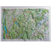

Dorrigo 3D Map Of The Pyrenees
This raised relief map shows the Pyrenees between France and Spain in a 1:375 000 scale. The simplified mapping shows key physical features, including the mountain peaks with spot heights, towns, main roads, rivers, and other features. This 3D map includes the Principality of Andorra and other popular skiing and walking area. Due to the size of these products they will be sent by courier only. Please add to cart and review the price for delivery to your address in the checkout.
Product Description
Reviews/Comments
Add New
Intelligent Comparison
Archived Product
Dorrigo 3D Map Of Italy Ordnance Survey
£59.99
Archived Product
Dorrigo 3D Map Of Germany Ordnance Survey
£69.99
Archived Product
Dorrigo 3D Map Of France Ordnance Survey
£149.99
Vouchers
No voucher codes found.
Do you know a voucher code for this product or supplier? Add it to Insights for others to use.
Do you know a voucher code for this product or supplier? Add it to Insights for others to use.
 Denmark