
 United Kingdom
 France
 Germany
 Netherlands
 Sweden
 USA
USA
 Italy
Italy
 Spain
Spain
More From Contributor


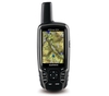

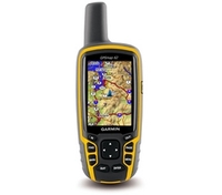
Garmin GPSMAP 62 Handheld Navigator
Garmin GPSMAP 62 Handheld Navigator
When the terrain gets tough, you can depend on the GPSMAP 62 handheld navigator to guide you through. Inspired by the powerful GPSMAP 60 series, this rugged and waterproof GPS combines high-precision accuracy with high functionality to brave the demands of any terrain you dare to tackle - wherever the adventure, whatever the activity.
Explore The Terrain
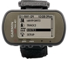
GPSMAP 62 features a 2.6-inch sunlight-readable colour screen with built-in worldwide basemap with shaded relief, so you can navigate anywhere with ease. With photo navigation, you can download pictures from Garmin ConnectTM Photos and navigate to them.
Keep Your Fix
With a quad helix antenna and high-sensitivity, WAAS/EGNOS-enabled GPS receiver with HotFix satellite prediction, GPSMAP 62 has
unparalleled reception to locate your position quickly and precisely and maintains its GPS location even in heavy cover and deep valleys. The advantage is clear - whether you're in deep woods or just near tall buildings and trees, you can count on GPSMAP 62 to help you find your way when you need it the most. Enhance Your Adventures With space to store up to 2000 waypoints and 200 routes, GPSMAP 62's detailed route planning and tracking helps you navigate from point-to-point and keep track of your journey as you go. As you navigate to a destination on an active track, you can view upcoming elevation changes together with waypoints and key stages along the route for a clear picture of the journey ahead. And with customisable display, you can tailor GPSMAP 62's dashboard to show you the
details you need on your adventure. Adventure Further GPSMAP 62 has a built-in worldwide basemap with shaded relief. Adding more maps is easy with Garmin's wide array of detailed topographic, marine and road maps, which can be loaded to internal memory. Get Connected You've been busy exploring and now you want to store, save and share your routes, tracks and waypoints. With a simple connection to your computer and to the Internet, you can get a detailed analysis of your activities and send tracks to your outdoor device using Garmin ConnectTM. Simply upload activities saved on GPSMAP 62 from your hiking, camping or geocaching adventure to keep a record on the web or swap ideas and expeditions with others. This one-stop site offers an activity table and allows you to view your
activities on a map using GoogleTM Earth. Explore other routes uploaded by millions of Garmin Connect users and share your experiences on Twitter and Facebook. Getting started is easy, so get out there, explore, share and take your adventures further. Find Fun GPSMAP 62 supports geocaching GPX files for downloading geocaches and details straight to your unit. By going paperless, you're not only helping the environment but saving time you would otherwise waste manually entering cache details before you set off. GPSMAP 62 stores and displays key information, including location, terrain, difficulty, hints and descriptions, which means no more manually entering coordinates or paper print outs! Simply upload the GPX file to your unit and start hunting for caches. Slim and lightweight,
62 is the perfect companion for all your outdoor pursuits. GPSMAP 62: Take it to the extreme Features: Physical & Performance: Unit dimensions, WxHxD: 2.4" x 6.3" x 1.4" (6.1 x 16.0 x 3.6 cm) Display size, WxH: 1.43" x 2.15" (3.6 x 5.5 cm) 2.6" diag (6.6 cm) Display resolution, WxH: 160 x 240 pixels Display type: transflective, 65-K colour TFT Weight: 9.2 oz (260.1 g) with batteries Battery: 2 AA batteries (not included) NiMH or Lithium recommended Battery life: 20 hours Waterproof: yes (IPX7) Floats: no High-sensitivity receiver: yes Interface: USB and NMEA 0183 compatible Maps & Memory: Basemap: yes Preloaded maps: no Ability to add maps: yes Built-in memory: 1.7 GB Accepts data
cards: no Waypoints/favorites/locations: 2000 Routes: 200 Track log: 10, 000 points, 200 saved tracks Features & Benefits: Automatic routing (turn by turn routing on roads): yes (with optional mapping for detailed roads) Electronic compass: no Touchscreen: no Barometric altimeter: no Camera: no Geocaching-friendly: yes (paperless) Custom maps compatible: yes Photo navigation (navigate to geotagged photos): yes Outdoor GPS games: no Hunt/fish calendar: yes Sun and moon information: yes Tide tables: Yes (with optional Bluechart) Area calculation: yes Custom POIs (ability to add additional points of interest): yes Unit-to-unit transfer (shares data wirelessly with similar units): no Picture viewer: yes Garmin ConnectTM compatible (online
community where you analyze, categorize and share data): yes
Product Description
Reviews/Comments
Add New
Vouchers
No voucher codes found.
Do you know a voucher code for this product or supplier? Add it to Insights for others to use.
Do you know a voucher code for this product or supplier? Add it to Insights for others to use.
 Denmark