
 United Kingdom
 France
 Germany
 Netherlands
 Sweden
 USA
USA
 Italy
Italy
 Spain
Spain
More From Contributor

Garmin Edge 800 GPS Bike Navigator (With Heart Rate And Cadence)
Garmin Edge 800 GPS Bike Navigator (With Heart Rate and Cadence)
Make the most of every ride with Edge 800 - the ultimate touchscreen GPS bike computer for training, touring and on the trail. Providing navigation and performance monitoring, Edge 800 is ideal for touring, commuting, competitive cycling and mountain biking. It has a built-in basemap and tracks your distance, speed, location and ascent/descent. Use it with an ANT+TM heart rate monitor¹, speed/cadence sensor¹ or compatible power meter² for a finely tuned analysis of your ride.
At Your Fingertips
Edge 800's touchscreen display is rugged enough to stand up to the elements, yet sensitive enough to respond to the tap of your gloved hand. Switch training pages or pan and zoom the map with just a tap. The bright,
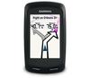
sunlight-readable colour display is easy to view in all lighting conditions. Just don't let its good looks fool you - Edge 800 is waterproof to IPX7 standards and can withstand hard knocks and scrapes it might endure in mountain biking environments. The aerodynamic Edge 800 has a carbon fibre construction with either blue or white accents and attaches to the stem or handlebar of your bike with the low-profile mount. A quarter-turn mount design holds unit securely and lets you easily swap it between bikes using removable, reusable bands. Know Where To Go Whether your bike is a means of transportation or escape, having maps at your fingertips makes every ride easier, more clued-up and more fun. Edge 800 comes with a built-in basemap that shows major roads and cities, plus it's
compatible with our range of microSDTM cards to add your choice of street¹ or recreation maps³. Select your destination and Edge 800 provides turn-by-turn navigation prompts on the screen to guide your ride there. Edge 800 is available with Garmin GB DiscovererTM 1:50, 000 scale Ordnance Survey mapping for the whole of Britain. With contours, elevations, summits, paths, routable roads and more, it's ideal for biking anywhere in Britain on any terrain. Or choose optional plug-in 1:25k scale GB Discoverer maps for OS Explorer Map detail of your favourite National Parks (19 titles) or National Trail (17 titles). Other Edge 800 bundles available to suit your style of riding include mapping options for navigation on and off-road and performance options with heart rate and
speed/cadence sensors. Edge 800 can also guide you along routes recorded by other cyclists. Explore our Garmin ConnectTM site and choose from millions of rides uploaded by other users. Any activities you upload to your Edge 800 are stored as courses. You can follow the course with navigation prompts or, for a little competition, race it and try to beat previously set goals. Don't waste precious time planning your adventure when you're already outside. Our free BaseCampTM software lets you create routes on your computer and then transfer to your Edge 800 in incredible detail with 2D, 3D and elevation views. Edge 800 records your every move with a high-sensitivity GPS receiver that stays locked on to a signal, even under tree cover. The receiver features HotFix satellite prediction to
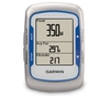
calculate your position faster, plus it has automatic time zone adjustment ideal for a European cycle tour holiday. Data, Any Way You Want It Edge 800 tracks a variety of data from your ride and lets you customise up to three training pages so you can see as much or as little ride information as you want. The barometric altimeter provides extra-precise climb and descent data and records temperature changes. If you're a performance cyclist, you can pair Edge 800 with a third-party ANT+ enabled power meter to display your power output in watts as you ride. This valuable data shows you how hard you're working, regardless of conditions affecting your ride, so you can train smarter. Some versions of Edge 800 also come with a speed/cadence sensor and heart rate monitor. Training Tools Need
a little motivation to push your performance? See how you measure up to the Virtual Partner - a digital depiction of your goal speed vs. your speed in real-time. Other training features include detailed workout planning, Auto Pause, Auto Lap and Courses, which helps you compare successive rides over the same route. Analyse Your Ride You logged the miles, now it's time to review, replay and share your ride. Just upload your data to Garmin ConnectTM, our website for free data analysis and sharing. You can upload from your PC or Mac using the included USB cable. At Garmin ConnectTM, you can see the route you've ridden on a map, view a summary of your ride, create goals, share rides and data with others and much more. Edge 800: The ultimate touchscreen GPS bike computer for training,
touring and on the trail Specifictions: Physical & Performance: Unit dimensions, WxHxD: 2.0" x 3.7" x 1.0" (5.1 x 9.3 x 2.5 cm) Display size, WxH: 1.4" x 2.2" (3.6 x 5.5 cm) 2.6" diag (6.6 cm) Display resolution, WxH: 160 x 240 pixels, touchscreen Touchscreen: yes Weight: 3.5 oz (98.0 g) Battery: rechargeable lithium-ion Battery life: 15 hours, typical Water resistant: yes (IPX7) GPS-enabled: yes High-sensitivity receiver: yes Maps & Memory: Basemap: yes Ability to add maps: yes Accepts data cards: microSDTM card (some versions include a CityNavigator microSD card) History: 1000 laps Waypoints/favorites/locations: 200 Routes: Limited by memory space available Features & Benefits: Heart
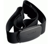
rate monitor: yes (some versions) Bike speed/cadence sensor: yes (some versions) Foot pod: no Automatic sync (automatically transfers data to your computer): no Garmin ConnectTM compatible (online community where you analyze, categorize and share data): yes Virtual Partner (train against a digital person): yes Virtual RacerTM (compete against other activities): no Courses (compete against previous activities): yes Auto Pause (pauses and resumes timer based on speed): yes Auto Lap (automatically starts a new lap): yes Auto Scroll (cycles through data pages during workout): yes Multi-sport (changes sport mode with a press of a button): no Advanced workouts (create custom, goal-oriented workouts): yes Pace alert (triggers alarm if you vary from preset
pace): yes Time/distance alert (triggers alarm when you reach goal): yes Vibration alert: (choose between alert tones and/or vibration alert): no Interval training (set up exercise and rest intervals): yes Heart rate-based calorie computation: yes Swim metrics (stroke type, stroke count and pool lengths): no Training Effect (measures impact of an activity on your aerobic fitness): no Customizable screen(s): yes Barometric altimeter: yes Unit-to-unit transfer (shares data wirelessly with similar units): no Power meter compatible (displays power data from compatible 3rd party ANT+TM-enabled power meters): yes (records data approx. 1 per second) Temperature (displays and records temperature while you ride): yes Sport watch: no Additional: Operating temperature: -20C
to +60C What's in the Box: The Edge 800 is available in two different versions. See Versions tab for details. Edge 800 Black/White Version *Edge 800 *Bike mount *AC charger *USB cable *Manual Edge 800 Blue Bundled Version *Edge 800 *Premium heart rate monitor *Speed/cadence sensor *Data card preloaded with City Navigator for Europe street maps (maps on a preloaded data card cannot be copied or viewed on a computer) *Bike mount *AC charger *USB cable *Manual
sunlight-readable colour display is easy to view in all lighting conditions. Just don't let its good looks fool you - Edge 800 is waterproof to IPX7 standards and can withstand hard knocks and scrapes it might endure in mountain biking environments. The aerodynamic Edge 800 has a carbon fibre construction with either blue or white accents and attaches to the stem or handlebar of your bike with the low-profile mount. A quarter-turn mount design holds unit securely and lets you easily swap it between bikes using removable, reusable bands. Know Where To Go Whether your bike is a means of transportation or escape, having maps at your fingertips makes every ride easier, more clued-up and more fun. Edge 800 comes with a built-in basemap that shows major roads and cities, plus it's
compatible with our range of microSDTM cards to add your choice of street¹ or recreation maps³. Select your destination and Edge 800 provides turn-by-turn navigation prompts on the screen to guide your ride there. Edge 800 is available with Garmin GB DiscovererTM 1:50, 000 scale Ordnance Survey mapping for the whole of Britain. With contours, elevations, summits, paths, routable roads and more, it's ideal for biking anywhere in Britain on any terrain. Or choose optional plug-in 1:25k scale GB Discoverer maps for OS Explorer Map detail of your favourite National Parks (19 titles) or National Trail (17 titles). Other Edge 800 bundles available to suit your style of riding include mapping options for navigation on and off-road and performance options with heart rate and
speed/cadence sensors. Edge 800 can also guide you along routes recorded by other cyclists. Explore our Garmin ConnectTM site and choose from millions of rides uploaded by other users. Any activities you upload to your Edge 800 are stored as courses. You can follow the course with navigation prompts or, for a little competition, race it and try to beat previously set goals. Don't waste precious time planning your adventure when you're already outside. Our free BaseCampTM software lets you create routes on your computer and then transfer to your Edge 800 in incredible detail with 2D, 3D and elevation views. Edge 800 records your every move with a high-sensitivity GPS receiver that stays locked on to a signal, even under tree cover. The receiver features HotFix satellite prediction to
calculate your position faster, plus it has automatic time zone adjustment ideal for a European cycle tour holiday. Data, Any Way You Want It Edge 800 tracks a variety of data from your ride and lets you customise up to three training pages so you can see as much or as little ride information as you want. The barometric altimeter provides extra-precise climb and descent data and records temperature changes. If you're a performance cyclist, you can pair Edge 800 with a third-party ANT+ enabled power meter to display your power output in watts as you ride. This valuable data shows you how hard you're working, regardless of conditions affecting your ride, so you can train smarter. Some versions of Edge 800 also come with a speed/cadence sensor and heart rate monitor. Training Tools Need
a little motivation to push your performance? See how you measure up to the Virtual Partner - a digital depiction of your goal speed vs. your speed in real-time. Other training features include detailed workout planning, Auto Pause, Auto Lap and Courses, which helps you compare successive rides over the same route. Analyse Your Ride You logged the miles, now it's time to review, replay and share your ride. Just upload your data to Garmin ConnectTM, our website for free data analysis and sharing. You can upload from your PC or Mac using the included USB cable. At Garmin ConnectTM, you can see the route you've ridden on a map, view a summary of your ride, create goals, share rides and data with others and much more. Edge 800: The ultimate touchscreen GPS bike computer for training,
touring and on the trail Specifictions: Physical & Performance: Unit dimensions, WxHxD: 2.0" x 3.7" x 1.0" (5.1 x 9.3 x 2.5 cm) Display size, WxH: 1.4" x 2.2" (3.6 x 5.5 cm) 2.6" diag (6.6 cm) Display resolution, WxH: 160 x 240 pixels, touchscreen Touchscreen: yes Weight: 3.5 oz (98.0 g) Battery: rechargeable lithium-ion Battery life: 15 hours, typical Water resistant: yes (IPX7) GPS-enabled: yes High-sensitivity receiver: yes Maps & Memory: Basemap: yes Ability to add maps: yes Accepts data cards: microSDTM card (some versions include a CityNavigator microSD card) History: 1000 laps Waypoints/favorites/locations: 200 Routes: Limited by memory space available Features & Benefits: Heart
rate monitor: yes (some versions) Bike speed/cadence sensor: yes (some versions) Foot pod: no Automatic sync (automatically transfers data to your computer): no Garmin ConnectTM compatible (online community where you analyze, categorize and share data): yes Virtual Partner (train against a digital person): yes Virtual RacerTM (compete against other activities): no Courses (compete against previous activities): yes Auto Pause (pauses and resumes timer based on speed): yes Auto Lap (automatically starts a new lap): yes Auto Scroll (cycles through data pages during workout): yes Multi-sport (changes sport mode with a press of a button): no Advanced workouts (create custom, goal-oriented workouts): yes Pace alert (triggers alarm if you vary from preset
pace): yes Time/distance alert (triggers alarm when you reach goal): yes Vibration alert: (choose between alert tones and/or vibration alert): no Interval training (set up exercise and rest intervals): yes Heart rate-based calorie computation: yes Swim metrics (stroke type, stroke count and pool lengths): no Training Effect (measures impact of an activity on your aerobic fitness): no Customizable screen(s): yes Barometric altimeter: yes Unit-to-unit transfer (shares data wirelessly with similar units): no Power meter compatible (displays power data from compatible 3rd party ANT+TM-enabled power meters): yes (records data approx. 1 per second) Temperature (displays and records temperature while you ride): yes Sport watch: no Additional: Operating temperature: -20C
to +60C What's in the Box: The Edge 800 is available in two different versions. See Versions tab for details. Edge 800 Black/White Version *Edge 800 *Bike mount *AC charger *USB cable *Manual Edge 800 Blue Bundled Version *Edge 800 *Premium heart rate monitor *Speed/cadence sensor *Data card preloaded with City Navigator for Europe street maps (maps on a preloaded data card cannot be copied or viewed on a computer) *Bike mount *AC charger *USB cable *Manual
 "Pin It")
Product Description
Reviews/Comments
Add New
Vouchers
No voucher codes found.
Do you know a voucher code for this product or supplier? Add it to Insights for others to use.
Do you know a voucher code for this product or supplier? Add it to Insights for others to use.
 Denmark