
 United Kingdom
 France
 Germany
 Netherlands
 Sweden
 USA
USA
 Italy
Italy
 Spain
Spain
More From Contributor

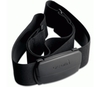


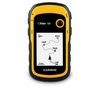
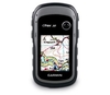
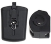
Garmin Edge 500 (with Speed/Cadence & HRM)
The Edge Series is compact, lightweight, waterproof units that have the ability to accurately monitor speed (Cadence Sensor) Heart Rate (Heart Rate Monitor) Vertical profiles, climb and descent, altitude, speed, distance and time.
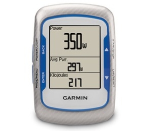
Sharpen your cycling performance with Edge 500, a lightweight GPS-based cycling computer for performance-driven cyclists. Loaded with data, Edge 500 tracks your distance, speed, location and elevation with high sensitivity GPS. Add an ANT+TM compatible heart rate monitor, speed/cadence sensor or compatible power meter for a finely-tuned analysis of your ride.Jumpstart Your TrainingThe Edge 500 attaches easily to the stem or handlebars of your bike with its low-profile bike mount. The Edge attaches easily to the mount with a simple quarter-turn. When
you're ready to ride, just power on your Edge, acquire GPS satellites and go. Edge 500 features a high-sensitivity GPS receiver with HotFixTM satellite prediction to calculate your position faster.Get the Data You NeedDuring your ride, Edge 500 measures your speed, distance, time, calories burned, altitude, climb and descent, and records this data for your review. For extra-precise climb and descent data, Edge 500 also incorporates a barometric altimeter to pinpoint changes in elevation.All Edge 500 versions work with third-party ANT+-enabled power meters to display your power output in watts as you ride. This valuable data shows you how hard you're working, regardless of conditions affecting your ride, so you can train smarter. Some versions also ship with a digital heart rate
monitor and speed/cadence sensor. Other helpful training features include a Courses feature, which helps you compare successive rides over the same route, as well as Auto Pause, Auto Lap and temperature readings. Edge also alerts you if you're moving but the timer is not running.Track Your Heart RateWhen paired with a Garmin heart rate monitor, Edge 500 tracks heart beats per minute and uses your heart rate for advanced calorie computation, so you know how many calories you're burning. Train in a certain heart-rate zone to improve your fitness level or compare your pace and heart rate to past performance over the same ride. Analyze Your RideOnce your ride's done, connect Edge 500 to your computer with the included USB cable to analyze your performance. With a simple click, you can
join a worldwide network of cyclists and outdoor enthusiasts through Garmin ConnectTM, a one-stop site for data analysis and sharing.
 "Pin It")
Product Description
Reviews/Comments
Add New
Vouchers
No voucher codes found.
Do you know a voucher code for this product or supplier? Add it to Insights for others to use.
Do you know a voucher code for this product or supplier? Add it to Insights for others to use.
 Denmark