
 United Kingdom
 France
 Germany
 Netherlands
 Sweden
 USA
USA
 Italy
Italy
 Spain
Spain
More From Contributor

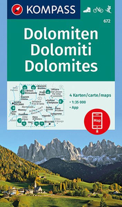
Dolomites 4-Map Set Kompass 672
The heart of the Dolomites on four double-sided, contoured and GPS compatible. recreational maps at 1:35, 000 from Kompass highlighting hiking trails including the Alte Vie, mountain bike routes, various types of tourist accommodations, recreational facilities, etc. The set provides very wide coverage of the mountains, extending eastwards from Bolzano to well beyond Cortina d’Ampezzo and from Brunico/Bruneck in the north to Belluno, including the most popular of the High Routes (Alte Vie), Val Gardena, Marmolada massif, etc.Topography is vividly present by contours at 40m or 50m intervals enhanced by numerous spot heights, shading and graphic relief, plus colouring and/or graphics for different types of vegetation. National parks and other protected areas are marked.
Extensive overprint highlights numerous hiking trails, indicating where appropriate difficult and/or via ferrata sections, also their waymarking numbers or symbols for the long-distance trails (including the Alte Vie, Sentiero Italia, Via Alpina, etc). Also marked are cycling and mountain biking routes (including Via Claudia Augusta), horse riding trails, plus cross-country and selected alpine ski routes. A very wide range of symbols indicates various accommodation options (hotels and inns, huts, campsites, youth hostels, etc), cycle hire and repair shops, sport and recreational facilities, etc. Road network shows toll routes, car parks and Park+Ride facilites, and all forms of mountain transport are included (cable cars, chair lifts, etc). The maps have a 1km UTM grid.
Map legend includes English.To see the list of other titles in this series please click on the series link.

Product Description
Reviews/Comments
Add New
Vouchers
No voucher codes found.
Do you know a voucher code for this product or supplier? Add it to Insights for others to use.
Do you know a voucher code for this product or supplier? Add it to Insights for others to use.
 Denmark