More From Contributor
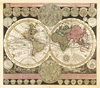
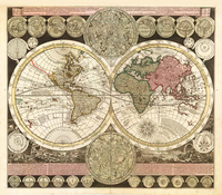
£12.99
Zurich, map No. 225, in the standard topographic survey of Switzerland at 1:50, 000 from Swisstopo, i.e. without the special overprint highlighting walking trails, local bus stops, etc, presented in Swisstopo’s hiking editions of the 50K survey. Highly regarded for their superb use of graphic relief & hill shading, the maps give an almost 3-D picture of Switzerland`s mountainous terrain. Contours are at 20m intervals. All the maps have a 1-km grid with the Swiss national coordinates. This standard version of the 50K survey covers the whole country on 78 small format sheets, with special larger format maps published for several popular tourist destinations. Small format sheets cover an area of 35 x 24 km (21 x 15 miles approx) & have map legend in the language of the area covered by the map. The special larger sheets cover 50 x 35 km (31 x 22 miles approx) & have no map legend, but a separate leaflet can be provided instead.PLEASE NOTE: the hiking editions of the 1:50, 000 Swisstopo survey are listed on our website in a separate series. ...
Archived Product
£18.99
Zürich area, map No. 225T, at 1:50, 000 in a special hiking edition of the country’s topographic survey, published by Swisstopo in cooperation with the Swiss Hiking Federation. Cartography, identical to the standard version of the survey, is highly regarded for its superb use of graphic relief & hill shading to provide an almost 3-D picture of Switzerland`s mountainous terrain. Contours are at 20m intervals. An overprint highlights routes maintained by the SHF, distinguishing between hiking routes, mountain routes requiring proper footwear, & alpine routes where equipment is needed. Paths which are part of the national or regional network of long-distance hiking routes are specially marked & in the more recent editions are annotated with their official numbers. The maps show mountain huts, refuges & in remote areas also inns, plus roads with bus service & the positions of bus stops. All the maps have a 1-km grid of the Swiss national coordinates. For a list of all the titles in this series, please click on the series link. ...
Archived Product
£15.99
Zurich VBZ city map is an indexed, official city map of Zurich’s public transport network at a scale of 1:15, 000. Stations, transport lines, stops & termini, route numbers, ticket offices, parking facilities, car hire locations & taxi ranks are all fore grounded against a fainter displayed city plan. This map features bus & tram ways on VBZ Zuri lines, regional lines & post bus lines, as well as S-Bahn & RER rail lines, cable/funicular railways, ZSG boat cruises & ferry routes. Camping sites, shopping centres, places of worship, post offices, monuments, museums & theatres are all vividly superimposed against the city backdrop, as well as the more specific local interest of shooting range locations.A more detailed city centre street plan at a scale of 1:10, 000 is provided as an insert, with clear indications of the many one way streets to be navigated. ...
Archived Product
£6.95
Zurich in the Wallpaper* City Guide series, published by Phaidon & encompassing a collection of pocket-size guides dedicated to the best design elements in major cities. Compiled by experts at the Wallpaper* magazine, the guides are widely recognized for appealing to design-conscious travellers & are aimed at those interested in art, design & architecture. Each guide identifies the best bars, restaurants, hotels, places to shop, leisure activities & excursions with a unique emphasis on the finest examples of unusual architecture & design. Each Wallpaper* City Guide has the same layout, with separate tabs allowing readers & travellers to access individual sections easily. The tabs consist of Landmarks, Hotels, 24 Hours, Urban Life, Architour, Shopping, Sports & Escapes. High quality colour photographs appear alongside brief descriptions of each hotel, bar or attraction, highlighting distinctive & unusual styles of architecture & design. Extra pages are provided at the back of each guide, allowing readers to record their own notes & sketches. ...
Archived Product
£6.95
Topographic coverage of mainland Spain at 1:50, 000 in the MTN50 (Mapa Topográfico Nacional) series from the Centro Nacional de Información Geografica, the country’s civilian survey organization. The maps have contours at 20m intervals, enhanced by relief shading, plus colouring and/or graphics to show different types of terrain, vegetation or land use. Boundaries of national parks & other protected areas are marked. In addition to all the usual information featured on topographic mapping at this scale, detailed presentation of the road & rail networks, rural tracks & paths, etc, the maps also show campsites & mountain refuges. On more recent editions some GRs, the official long-distance hiking routes, are also marked (although not as clearly as on hiking maps from other publishers). Each map covers 29.5x 18.5 km (with adjustments in the border or coastal areas). The maps have a 1-km UTM grid, plus margin ticks for latitude & longitude at 1` intervals. Map legend is in Spanish only.HOW TO CHOOSE THE RIGHT 50K MAP: all the titles in CNIG’s 200K Provincial Road Maps series at 1:200, 000 are overprinted with the grid for the 1:50, 000 maps & can be used to see the area covered by each 50K title. TO SEE THE LIST OF TITLES IN THIS SERIES PLEASE CLICK ON THE SERIES LINK.PLEASE NOTE
- MAP TITLES: the grids shown on our website serve both the civilian & the military 1:50, 000 topographic series. Although the areas covered by maps in both series are identical (apart from some border or coastal sheets), occasionally map titles differ – only one title is shown on the grid, usually the military one. In Galicia, the Basque country & in the Catalan speaking areas the tendency now is to use local place names rather than the often better known Castilian ones. Where possible, both versions are included in our titles. Map titles listed on our website are based on information received by us at the time of publication, but sometimes maps arrive showing a completely different title! As long as the map number is as ordered, the correct map has been supplied.
...
Archived Product
£8.99
An attractive & decorative map of the world drawn by Zurner in about 1710. The map depicts the geographical knowledge of Europeans at the time
- eastern Australia & western North America are largely blank spaces. The interior of Africa is wildly inaccurate
- the Nile, Niger & Congo rivers all join up & the Niger flows in the wrong direction! Small diagrams around the edges of the map depict various other themes such as the planets. Overall a fascinating document.

...
Archived Product
£9.50
Topographical survey of Belgium at 1:20, 000 from Nationaal Geografisch Instituut / Institut Géographique National, the country’s national survey organization. Each 20K map covers one quarter of the corresponding 1:50, 000 map (with adjustments in the border & coastal areas). The maps provide all the information expected of topographic mapping at this scale & in addition have an unusually large amount of vegetation and/or land use information (different types of woodlands, gardens, orchards, heath, etc). The maps have a 1-km UTM grid, with margin ticks for latitude & longitude at intervals of 1`. Map legend & a glossary of terms used on the maps include English. Stanfords keeps as regular stock 20K maps for the World War I battlefields around the Ypres, Messines & Passchendaele, & for the area of the Battle of Waterloo. The 1:20, 000 survey covers the whole of Belgium & maps for other regions can be supplied as special orders. To see the list of titles in this series please click on the series link.PLEASE NOTE: the Long-Distance Footpaths Map of Belgium at 1:300, 000 which shows the division of Belgium into the 50K survey sheets can also be used to see in more detail coverage by the 20K maps. ...
Archived Product
£12.99
Map No. 1246, Zweisimmen, in the topographic survey of Switzerland at 1:25, 000 from Bundesamt für Landestopographie (swisstopo), covering the whole country on 247 small format sheets, with special larger maps published for popular regions including some titles now available in hiking versions. Highly regarded for their superb use of graphic relief & hill shading, the maps give an almost 3-D picture of Switzerland`s mountainous terrain. Contours are at 10 m intervals, with 20m intervals in the mountainous areas. All the maps have a 1-km grid for Swiss national coordinates (datum CH 1903). * Small format sheets (Nos. 1011
- 1374)* Map legend in the language of the area covered by the map. Additional margin ticks show latitude & longitude in steps of 2`. The area covered by each map is 17 x 12 km (11 x 7 miles approx). * Special larger sheets (Nos. from 2501 onwards) – STANDARD editions:* No map legend is included but a separate leaflet can be provided instead. The area covered by each map is 25 x 17 km (15 x 11 miles approx).* Special larger sheets (Nos. from 2501 onwards) – HIKING editions:* An overprint highlights hiking, mountain & alpine paths, including regional & national long-distance trails. The maps also show bus routes with bus stops, plus inns in remote locations. The area covered by each map is 25 x 17 km (15 x 11 miles approx).
...
Archived Product
£4.95
ADAC, Germany's equivalent of the British Automobile Association publishes an extensive series of street plans which provide detailed high-quality mapping of all the major towns & cities, including their outer suburbs. The plans name all the individual streets & indicate all the main landmarks & public buildings. All public transport facilities are shown: buses, trams, underground & overland rail lines. One way streets & car parks are indicated. Plans of larger cities include an enlargement for the city centre. The plans also show the administrative & postal divisions & have an extensive street index which, where appropriate, shows individual postal codes for each street. On the reverse, each plan has a road map at 1:100, 000, covering a very wide area around the city. Map legend

Includes::
English.

...
Archived Product
£8.99
Zwickau on a topographic map at 1:200, 000 from the Bundesamt für Kartographie und Geodäsie, Germany’s federal mapping agency. The map covers an area of Approx. 100 x 90km. This map is belongs to a series of 58 topographic maps from Bundesamt für Kartographie und Geodäsie, the federal cartographic agency of Germany responsible for topographic mapping at 1:200, 000 & maps at smaller scales (the more detailed topographic & leisure maps are prepared & published by the survey organizations of the individual states). Cartography is from the 200K topographic survey & the maps have very elegant, modern look whilst retaining the traditional German presentation of names of smaller towns & villages in italics. Contours are at 12, 5m intervals, enhanced by relief shading, with colouring for woodlands, moors, marches, vineyards & hop plantations. Waterways & rivers are also described in detail, with currents, waterfalls, dams, & jetties clearly marked. Road network, graded into five types, highlights in colour national & regional roads; no driving distances are marked Railway network is also shown in detail, with stations, goods only lines, etc. The maps show administrative boundaries of states & counties, & have a UTM grid plus margin ticks for latitude & longitude at 2’ intervals. Map legend is in German only. PLEASE NOTE: maps in this series provide an excellent presentation of the areas covered by them, with plenty of place names & detailed representation of the road network, & will appeal to anyone who likes quality cartography, but they are not necessarily the best option for holiday & business travel. To see other titles in this series please click on the series link. ...
Archived Product

Zurner's World 1710

An attractive and decorative map of the world drawn by Zurner in about 1710. The map depicts the geographical knowledge of Europeans at the time - eastern Australia and western North America are largely blank spaces. The interior of Africa is wildly inaccurate - the Nile, Niger and Congo rivers all join up and the Niger flows in the wrong direction! Small diagrams around the edges of the map depict various other themes such as the planets. Overall a fascinating document.
RIP - This product is no longer available on our network. It was last seen on 25.09.2019

This page now acts as a permanent archive for this product. Add more information using the comments box below to ensure it can still be found by future generations.

Use our search facility to see if it is available from an alternative contributor.
  • Availability: Out Of Stock
  • Supplier: Stanfords
  • SKU: XL00000015712
Availability: In Stock
£12.95

Product Description

An attractive & decorative map of the world drawn by Zurner in about 1710. The map depicts the geographical knowledge of Europeans at the time
- eastern Australia & western North America are largely blank spaces. The interior of Africa is wildly inaccurate
- the Nile, Niger & Congo rivers all join up & the Niger flows in the wrong direction! Small diagrams around the edges of the map depict various other themes such as the planets. Overall a fascinating document.

Reviews/Comments

Add New

Price History

Vouchers

No voucher codes found.
Do you know a voucher code for this product or supplier? Add it to Insights for others to use.

Facebook

Jargon Buster

World - A physical grouping, commonly used to describe earth and everything associated with ti
Small - something that takes up less space than normal.
Interior - The inside of something, usually what is not visible.
Decorative - Making things look more appealing and attractive.

Supplier Information

Stanfords
Stanfords was established in 1853 and opened their iconic Covent Garden flagship store in 1901. They have become the top retailer of maps, travel books and accessories in the UK and arguably offer the largest selection of maps and travel books worldwide. Famous names such as Captain Robert Falcon Scott, Ranulph Fiennes and Michael Palin have purchased from Stanfords. They now have a shop in Bristol and both stores together with other venues operate a calendar of events including talks, book signings and exhibitions. As a specialist map retailer, the map selection is comprehensive and includes road maps, street maps and walking maps from worldwide destinations, as well as a selection of world atlases and wall maps. Books include travel guides and travel literature. Stanfords also stock globes, from miniatures made of blue marble to magnificent floor-standing globes. The website features a selection of interesting articles on travel topics.
Page Updated: 2023-11-12 20:15:36

Community Generated Product Tags

Oh No! The productWIKI community hasn't generated any tags for this product yet!
Menu