
 United Kingdom
 France
 Germany
 Netherlands
 Sweden
 USA
USA
 Italy
Italy
 Spain
Spain
More From Contributor

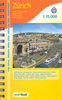

Zurich VBZ City Map
Zurich VBZ city map is an indexed, official city map of Zurich’s public transport network at a scale of 1:15, 000. Stations, transport lines, stops and termini, route numbers, ticket offices, parking facilities, car hire locations and taxi ranks are all fore grounded against a fainter displayed city plan. This map features bus and tram ways on VBZ Zuri lines, regional lines and post bus lines, as well as S-Bahn and RER rail lines, cable/funicular railways, ZSG boat cruises and ferry routes. Camping sites, shopping centres, places of worship, post offices, monuments, museums and theatres are all vividly superimposed against the city backdrop, as well as the more specific local interest of shooting range locations.A more detailed city centre street plan at a scale of 1:10,
000 is provided as an insert, with clear indications of the many one way streets to be navigated.
000 is provided as an insert, with clear indications of the many one way streets to be navigated.
Product Description
Reviews/Comments
Add New
Vouchers
No voucher codes found.
Do you know a voucher code for this product or supplier? Add it to Insights for others to use.
Do you know a voucher code for this product or supplier? Add it to Insights for others to use.
 Denmark