More From Contributor
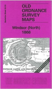
£4.99
Visitor Maps: Windsor & Windsor Great Park (3rd edition
- 2018) Folded sheet map
- 2 maps in 1. A doubled sided sheet map of

...
Archived Product
£3.50
Windsor Castle & Datchet in 1897 in a fascinating series of reproductions of old Ordnance Survey plans in the Alan Godfrey Editions, ideal for anyone interested in the history of their neighbourhood or family. Windsor is covered by two maps which also link with titles covering Eton & Slough to provided a block of four maps. WINDSOR map covers the west of the town, stretching from the GWR station & Peascod Street eastward to Dedworth Manor. Features include much of the town centre, Victoria Street, Windsor Bridge, the southern part of Eton High Street, Clarence Road, Alma Road, New Road, Holy Trinity church, St Mark`s School, Victoria Barracks, All Saints church, Clewer New Town, St Andrew`s Hospital, Clewer Hall, Clewer, Clewer Mill, etc. A commercial directory A to P is on the reverse.WINDSOR CASTLE & DATCHET covers the east of the town & an area eastward to Datchet. Features include Windsor Castle, LSWR station, Royal Mews, The Long Walk, High Street, Castle Hill, Frogmore Cottage, Frogmore House, Adelaide Lodge, Victoria Bridge, etc. On the east side of the Thames are Datchet station, St Mary`s church, Southlea, Churchmead House & Datchet village. On the reverse is a section of sheet 32.06 extending coverage north to Mirk, Riding Court, Upton Court, St Lawrence`s church, & the fringe of Slough. About the Alan Godfrey Editions of the 25” OS Series: Selected towns in Great Britain & Ireland are covered by maps showing the extent of urban development in the last decades of the 19th & early 20th century. The plans have been taken from the Ordnance Survey mapping & reprinted at about 15 inches to one mile (1:4, 340). On the reverse most maps have historical notes & many also include extracts from contemporary directories. Most maps cover about one mile (1.6kms) north/south, one & a half miles (2.4kms) across; adjoining sheets can be combined to provide wider coverage.FOR MORE INFORMATION & A COMPLETE LIST OF ALL AVAILABLE TITLES PLEASE CLICK ON THE SERIES LINK. ...
Archived Product
£3.50
This is a guide to one of the principal & favourite houses of the sovereign, which is visited by thousands of tourists from around the world each year. It explains Windsor Castle's rich history & its Royal use today, & guides the visitor round the parts open to the public, including the Albert Memorial Chapel, Queen Mary's Dolls' House & the magnificent St George's Chapel. It describes in detail the many treasures within: the principal features & furnishings, the tapestries & the objets d'art, & its picture collection. ...
Archived Product
£3.50
Windsor Forest & District in 1887 in a series of reproductions of Ordnance Survey’s famous ” Inch to the Mile” maps published in the Alan Godfrey Editions to provide a historical record of England & Wales on the second half of 19th & early 20th century. The map is centred on Windsor Great Park & covers the Thames Valley area around Windsor, Staines & Chertsey. Coverage stretches from Waltham St Lawrence eastward to Feltham, & from Slough southward to Sandhurst. Other locations include: in BERKSHIRE Ascot, Binfield, Bracknell, Bray, Clewer, Easthampstead, New Windsor, Old Windsor, Sunninghill, Warfield, White Waltham & Winkfield; in BUCKINGHAMSHIRE Datchet, Eton, Horton, Langley Marish, Upton cum Chalvey & Wyrardisbury; in MIDDLESEX & LONDON Ashford, Cranford, East Bedfont, Harington, Harmondsworth, Laleham, Littleton, Shepperton, Stanwell, Sunbury & West Drayton; plus in SURREY Addlestone, Bagshot, Chobham, Egham, Thorpe, Walton upon Thames, Weybridge & Windlesham. On the reverse is an extract from Middlesex Sheet 19.11 showing Stanwell in 1894, complete with directory. About the Alan Godfrey Editions of the OS Inch to the Mile Maps: the maps provide an invaluable overview of a wider area, typically 18 x 12 miles (29 x 19 kms approx.), & offer historical mapping for small towns & villages not covered by the more detailed series for which the Godfrey Editions are better known. On the reverse all the maps have historical notes & most titles also include a more detailed, large scale map of a small town or a village in the area. To see other titles in this series please click on the series link. ...
Archived Product
£5.75
Windsor Great Park at 1:14, 000 & central Windsor & Eton at 1:5, 000 a double-sided tourist map has plenty of information both for visitors to the town & for recreational pursuits in the Great Park. On one side is a clearly laid out, detailed street plan of central Winsdor with Eton, highlighting the Castle & the College & the main shopping areas on both sides of the Thames. The map clearly shows the town ...
Archived Product
£65.00
Pieces are housed in a cherry wood box with large brass hardware. Set

Includes::
two wood stylus, one glass

...
Archived Product
£3.50
Windsor South in 1968 in a series of exceptionally detailed reproductions of old Ordnance Survey street plans for areas of mainly larger cities which have undergone substantial redevelopment in the late 19th or the early 20th century, published in the Alan Godfrey Editions. The plans, printed in back & white, have been taken from the original Ordnance Survey mapping at 1:1, 056 & reproduced at 1:1, 760 – the equivalent of 36 inches (or one yard) to a mile. The maps provide an unrivalled, house-by-house picture of streets & individual buildings with inner courtyards, outbuildings, pavements, covered passages, etc. Many important institutions are named; within the National Galley on Trafalgar Square even the individual rooms (the map is from 1871, so no French Impressionists as yet!). On the reverse are historical notes about the area covered by the map, plus extracts from contemporary street directories. The two maps of Windsor, North & South, reveals the interior layout of many buildings, including Windsor Castle, & the mixed gauge track into the GWR station. Windsor North map

Includes::
Windsor Castle & precincts, GWR terminus, LSWR terminus, Windsor Bridge, Brewery, riverside, part of Eton High Street (but not the college). Windsor South map

Includes::
Peascod Street, Holy Trinity church, Infantry Barracks, Nachelors Acre, Royal Mews, etc, & has a list private residents from an 1891 directory. These maps provide a fascinating addition to Alan Godfrey’s huge series of some 2, 000 titles presenting reproductions of street plans at taken from the Ordnance Survey mapping at 1:2, 500 (25” to 1 mile) & reprinted at about 15 inches to one mile (1:4, 340).


...
Archived Product
£65.00
Compose a meaningful letter that will delight. Enjoy the wood boxes finished in rich & lustrous blue, locking with solid bronze hardware. This portable set comes with two wood styluses, eight brass nibs, & two large bottles of ink. If we do not have this item in stock we will order it for you from our supplier. Delivery generally takes 3 weeks within the UK. For overseas delivery queries please email sales@stanfords.co.uk ...
Archived Product
£9.99
Windsor, Slough & Uxbridge in the Cassini Past & Present map series which covers town & cities of England & Wales & offers a unique way of tracing their history & expansion by showing four different periods of their development using Ordnance Survey mapping from the mid-19th century, the late 19th century, the 1920s & the present day. Coverage

Includes::
Ashford, Egham, Hayes, London’s Heathrow Airport, Harlington, Harmondsworth, Hillingdon, Sipson, Staines, West Drayton & Yiewsley. Each Past & Present map consists of four panels, all centred on a city or a town & covering exactly the same 15km x 15km area. Three of the panels reproduce Ordnance Survey’s historical editions: the Old Series, the Revised New Series & the Popular Edition, enlarged from their original inch-to-the-mile to match the 1:50, 000 scale of the present-day Landranger extract shown in the fourth panel.* Old Series: the first detailed survey mapping dating from the first half of the 19th century, in black & white & with relief shown by hachuring.* Revised New Series from 1880s/1900s, with some colouring & a mixture of hachuring & contour lines.* Popular Edition from the inter-war years, with contour lines & colouring to indicate woodlands, parks, etc. National Grid lines are shown on all four panels for easy comparison across the four time periods. Historical notes, details of the original maps used & web-links for local history societies & other sources of information are also provided. *PLEASE NOTE:** Reproductions from the Ordnance Survey’s historical series are also available as maps of a wider area, with each title corresponding in its coverage to a present day Landranger map. Please see Great Britain: Cassini Historical Reproductions of Ordnance Survey One-Inch Maps series.* Stanfords can also print on request mapping from all the series *centring the map on a location of your choice.* For more information please click on the link below.

...
Archived Product
£6.39
A detailed topographic map from the Ordnance Survey Explorer series, covering Windsor, Weybridge, Bracknell & Wokingham (showing part of the Thames Path). Edition A4: Publication date March 2012 About this series: These highly detailed maps show all the administrative boundaries, settlements as small as isolated farms, the road network down to unfenced roads & country tracks, & field boundaries (hedges & drystone walls) which make navigation across the countryside much easier. Steep gradients on roads are indicated. Various landmarks, e.g. powerlines, archaeological sites, windmills, churches & lighthouses are shown & additional graphics indicate natural terrain features such as cliffs, scree, mud & vegetation variations. The contour interval is 5 metres in the lower parts of the country & 10 metres in the uplands, & spot heights are marked. Each map covers an area of 30 x 20km (i.e. approx. 19 x 12 miles), with some double-sided maps covering more, as indicated in the individual descriptions. The maps are fully GPS compatible, with the National Grid shown at 1km intervals & latitude & longitude indicated by margin ticks at 1'. The Explorer series has replaced the earlier, green-cover Pathfinder maps. The Explorer series is now complete & covers all of Engl&, Wales & Scotl&. Some sheets for popular areas like the National Parks are still branded as Outdoor Leisure (OL) maps, but are now included in this series as the cartography is the same as that in the Explorer Maps. The Explorer maps offer a substantial improvement on the Pathfinder series, with greater use of colour, larger area per map, & stronger emphasis on information for ramblers & tourists. This series is ideal for walking & other outdoor pursuits & each map shows a large amount of information for ramblers & tourists. Public rights of way are shown (except in Scotland), together with other routes with public access: National Trails & Recreational Paths, permitted paths & bridleways, & selected cycle routes. Open access land created under the Countryside & Rights of Way Act 2000 is marked. Tourist information

Includes::
caravan & camp sites, Park & Ride locations, recreation/leisure/sport centres, museums, historic buildings, English Heritage & National Trust sites, rural pubs, etc. The map legend is in English only, except for the tourist information content which is also in French & German.

...
Archived Product

Windsor North 1868

Windsor North in 1968 in a series of exceptionally detailed reproductions of old Ordnance Survey street plans for areas of mainly larger cities which have undergone substantial redevelopment in the late 19th or the early 20th century, published in the Alan Godfrey Editions.The plans, printed in back and white, have been taken from the original Ordnance Survey mapping at 1:1, 056 and reproduced at 1:1, 760 – the equivalent of 36 inches (or one yard) to a mile. The maps provide an unrivalled, house-by-house picture of streets and individual buildings with inner courtyards, outbuildings, pavements, covered passages, etc. Many important institutions are named; within the National Galley on Trafalgar Square even the individual rooms (the map is from 1871, so no French Impressionists
as yet!). On the reverse are historical notes about the area covered by the map, plus extracts from contemporary street directories.The two maps of Windsor, North and South, reveals the interior layout of many buildings, including Windsor Castle, and the mixed gauge track into the GWR station. Windsor North map includes Windsor Castle and precincts, GWR terminus, LSWR terminus, Windsor Bridge, Brewery, riverside, part of Eton High Street (but not the college). Windsor South map includes Peascod Street, Holy Trinity church, Infantry Barracks, Nachelors Acre, Royal Mews, etc, and has a list private residents from an 1891 directory.These maps provide a fascinating addition to Alan Godfrey’s huge series of some 2, 000 titles presenting reproductions of street plans at taken
from the Ordnance Survey mapping at 1:2, 500 (25” to 1 mile) and reprinted at about 15 inches to one mile (1:4, 340).
RIP - This product is no longer available on our network. It was last seen on 25.09.2019

This page now acts as a permanent archive for this product. Add more information using the comments box below to ensure it can still be found by future generations.

Use our search facility to see if it is available from an alternative contributor.
  • External links may include paid for promotion
  • Availability: Out Of Stock
  • Supplier: Stanfords
  • SKU: 9781847845313
Availability: In Stock
£3.50

Product Description

Windsor North in 1968 in a series of exceptionally detailed reproductions of old Ordnance Survey street plans for areas of mainly larger cities which have undergone substantial redevelopment in the late 19th or the early 20th century, published in the Alan Godfrey Editions. The plans, printed in back & white, have been taken from the original Ordnance Survey mapping at 1:1, 056 & reproduced at 1:1, 760 – the equivalent of 36 inches (or one yard) to a mile. The maps provide an unrivalled, house-by-house picture of streets & individual buildings with inner courtyards, outbuildings, pavements, covered passages, etc. Many important institutions are named; within the National Galley on Trafalgar Square even the individual rooms (the map is from 1871, so no French Impressionists as yet!). On the reverse are historical notes about the area covered by the map, plus extracts from contemporary street directories. The two maps of Windsor, North & South, reveals the interior layout of many buildings, including Windsor Castle, & the mixed gauge track into the GWR station. Windsor North map

Includes::
Windsor Castle & precincts, GWR terminus, LSWR terminus, Windsor Bridge, Brewery, riverside, part of Eton High Street (but not the college). Windsor South map

Includes::
Peascod Street, Holy Trinity church, Infantry Barracks, Nachelors Acre, Royal Mews, etc, & has a list private residents from an 1891 directory. These maps provide a fascinating addition to Alan Godfrey’s huge series of some 2, 000 titles presenting reproductions of street plans at taken from the Ordnance Survey mapping at 1:2, 500 (25” to 1 mile) & reprinted at about 15 inches to one mile (1:4, 340).

Reviews/Comments

Add New

Intelligent Comparison

Oooops!
We couldn't find anything!
Perhaps this product's unique.... Or perhaps we are still looking for comparisons!
Click to bump this page and we'll hurry up.

Price History

Vouchers

No voucher codes found.
Do you know a voucher code for this product or supplier? Add it to Insights for others to use.

Facebook

Jargon Buster

Contemporary - Modern era design
Contemporary - A design reference to indicate post war modern design
White - A colour combining all colours
Contemporary - An object that is living in the same time.
Interior - The inside of something, usually what is not visible.
Individual - A single separate item or person.

Supplier Information

Stanfords
Stanfords was established in 1853 and opened their iconic Covent Garden flagship store in 1901. They have become the top retailer of maps, travel books and accessories in the UK and arguably offer the largest selection of maps and travel books worldwide. Famous names such as Captain Robert Falcon Scott, Ranulph Fiennes and Michael Palin have purchased from Stanfords. They now have a shop in Bristol and both stores together with other venues operate a calendar of events including talks, book signings and exhibitions. As a specialist map retailer, the map selection is comprehensive and includes road maps, street maps and walking maps from worldwide destinations, as well as a selection of world atlases and wall maps. Books include travel guides and travel literature. Stanfords also stock globes, from miniatures made of blue marble to magnificent floor-standing globes. The website features a selection of interesting articles on travel topics.
Page Updated: 2023-11-12 20:15:36

Community Generated Product Tags

Oh No! The productWIKI community hasn't generated any tags for this product yet!
Menu