
 United Kingdom
 France
 Germany
 Netherlands
 Sweden
 USA
USA
 Italy
Italy
 Spain
Spain
More From Contributor


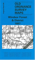
Windsor Forest And District 1887
Windsor Forest and District in 1887 in a series of reproductions of Ordnance Survey’s famous ”Inch to the Mile” maps published in the Alan Godfrey Editions to provide a historical record of England and Wales on the second half of 19th and early 20th century.The map is centred on Windsor Great Park and covers the Thames Valley area around Windsor, Staines and Chertsey. Coverage stretches from Waltham St Lawrence eastward to Feltham, and from Slough southward to Sandhurst. Other locations include: in BERKSHIRE Ascot, Binfield, Bracknell, Bray, Clewer, Easthampstead, New Windsor, Old Windsor, Sunninghill, Warfield, White Waltham and Winkfield; in BUCKINGHAMSHIRE Datchet, Eton, Horton, Langley Marish, Upton cum Chalvey and Wyrardisbury; in MIDDLESEX and LONDON Ashford,
Cranford, East Bedfont, Harington, Harmondsworth, Laleham, Littleton, Shepperton, Stanwell, Sunbury and West Drayton; plus in SURREY Addlestone, Bagshot, Chobham, Egham, Thorpe, Walton upon Thames, Weybridge and Windlesham. On the reverse is an extract from Middlesex Sheet 19.11 showing Stanwell in 1894, complete with directory.About the Alan Godfrey Editions of the OS Inch to the Mile Maps: the maps provide an invaluable overview of a wider area, typically 18 x 12 miles (29 x 19 kms approx.), and offer historical mapping for small towns and villages not covered by the more detailed series for which the Godfrey Editions are better known. On the reverse all the maps have historical notes and most titles also include a more detailed, large scale map of a small town or a
village in the area.To see other titles in this series please click on the series link.

Product Description
Reviews/Comments
Add New
Vouchers
No voucher codes found.
Do you know a voucher code for this product or supplier? Add it to Insights for others to use.
Do you know a voucher code for this product or supplier? Add it to Insights for others to use.
 Denmark