
 United Kingdom
 France
 Germany
 Netherlands
 Sweden
 USA
USA
 Italy
Italy
 Spain
Spain
More From Contributor


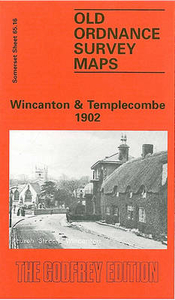
Wincanton And Templecombe 1902
Wincanton and Templecombe in 1902 in a fascinating series of reproductions of old Ordnance Survey plans in the Alan Godfrey Editions, ideal for anyone interested in the history of their neighbourhood or family. The map is double-sided; the main map covers most of Wincanton, extending from St Peter & St Paul`s church northward to the village of Charlton Musgrove, and eastward to Bayford. Features include the Workhouse, Church Street, High Street, Mill Street, North Street, Shadwell, Coneygore, Windmill Hill, Verrington Lodge, Balsam House, Bayford Lodge, Charlton House, Ireson House, St Stephen`s church (Charlton Musgrove). Note that the station is not included. On the reverse is a good section of Somerset sheet 75.16 covering the village of Templecombe, with its
complicated junction between the LSWR and Somerset & Dorset railways, well shown here with track layout. Features here include the station, St Mary`s church, Temple Combe, Abbas Combe and the Royal Hotel. About the Alan Godfrey Editions of the 25” OS SeriesSelected towns in Great Britain and Ireland are covered by maps showing the extent of urban development in the last decades of the 19th and early 20th century. The plans have been taken from the Ordnance Survey mapping and reprinted at about 15 inches to one mile (1:4, 340). On the reverse most maps have historical notes and many also include extracts from contemporary directories. Most maps cover about one mile (1.6kms) north/south, one and a half miles (2.4kms) across; adjoining sheets can be combined to provide wider
coverage.FOR MORE INFORMATION AND A COMPLETE LIST OF ALL AVAILABLE TITLES PLEASE CLICK ON THE SERIES LINK.

Product Description
Reviews/Comments
Add New
Vouchers
No voucher codes found.
Do you know a voucher code for this product or supplier? Add it to Insights for others to use.
Do you know a voucher code for this product or supplier? Add it to Insights for others to use.
 Denmark