
 United Kingdom
 France
 Germany
 Netherlands
 Sweden
 USA
USA
 Italy
Italy
 Spain
Spain
More From Contributor


Walthamstow Past
In the early 19th century, Walthamstow was described as 'the largest and handsomest surburban village near the metropolis'. Bordered by the river Lea on the west and Epping Forest on the east, it had many fine villas. The railway and industrial development in the Lea Valley changed it. Housing multiplied rapidly in an uncontrolled sprawl. In this new history, the author reminds us of the many splendours there were and are. Personalities include William Morris, who resided there and whose house is a museum, Clement Attlee and the young Sex Pistols.
Product Description
Reviews/Comments
Add New
Intelligent Comparison
Archived Product
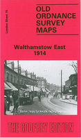
Walthamstow East 1914 Stanfords
£3.50
Archived Product

Walthamstow East 1939 Stanfords
£3.50
Archived Product

Walthamstow West 1913 Stanfords
£3.50
Archived Product

Walthamstow West 1936 Stanfords
£3.50
Vouchers
No voucher codes found.
Do you know a voucher code for this product or supplier? Add it to Insights for others to use.
Do you know a voucher code for this product or supplier? Add it to Insights for others to use.
 Denmark