
 United Kingdom
 France
 Germany
 Netherlands
 Sweden
 USA
USA
 Italy
Italy
 Spain
Spain
More From Contributor


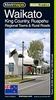

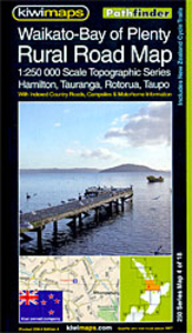
Waikato - Bay Of Plenty: Hamilton, Tauranga, Rotorua, Taupo
Waikato - Bay of Plenty region of New Zealand`s North Island, including Hamilton, Tauranga, Rotorua and Taupo, on a detailed, indexed road map at 1:250, 000 from Kiwimaps, with extensive tourist information including a table of facilities in local campsites, a comprehensive index, etc.Maps in a series indicate unsurfaced roads and 4WD tracks, and show names of both major highways (Pacific Coast, Highway, Great Alpine Highway, Southern Scenic Route, etc.) and of minor rural roads. Main hiking tracks, railways and ferry routes are also marked. National parks and nature reserves are highlighted, and an extensive range of symbols indicates places of interest, Lord of the Rings locations, numerous sport facilities, motor home/caravan parks and dump stations, interesting
geographical features, etc. Topography is shown by subtle but effective relief shading. The maps have no geographical coordinates.On the reverse each title has an index of both localities and names of rural roads, and lists geographical features such as mountains and passes, motor home and caravan sites, parks and reserves, etc. Also provided is a table showing what facilities are available in the local Department of Conservation campsites.To see the list of titles in this series please click on the series link.
geographical features, etc. Topography is shown by subtle but effective relief shading. The maps have no geographical coordinates.On the reverse each title has an index of both localities and names of rural roads, and lists geographical features such as mountains and passes, motor home and caravan sites, parks and reserves, etc. Also provided is a table showing what facilities are available in the local Department of Conservation campsites.To see the list of titles in this series please click on the series link.

Product Description
Reviews/Comments
Add New
Vouchers
No voucher codes found.
Do you know a voucher code for this product or supplier? Add it to Insights for others to use.
Do you know a voucher code for this product or supplier? Add it to Insights for others to use.
 Denmark