More From Contributor

£9.99
From Worm Charming to Bog Snorkelling, Nettle Eating to Shin Kicking, there`s a great British tradition of holding very strange contests in which getting filthy, feeling sick, risking life & limb
- & above all, looking ridiculous
- are not mere side-effects, but positively celebrated. Welcome to the Wacky Nation. James Bamber & Sally Raynes
- creators of wackynation.com
- present 50 of the oddest contests, races & traditions you`d never imagined existed. Think you`ve got what it takes to become the World Coal Carrying Champion, or may be the Greatest Liar? Perhaps your forte lies in Gurning? Look no further. With ratings for Spectator Fun, Pain Factor & Wackiness for each event, there`s a strong get-involved-if-you-dare streak, backed up by the intrepid authors` own experiences (with the scars to prove it) & tips from winners. Each entry will astound & amuse, enticing you to become a world champion or simply a laughing stock. With ” Wacky Nation”, you`ve no excuse for a dull weekend ever again.


...
Archived Product
£10.99
From the creator of the best selling black & white scanimation picture book Gallop! comes Waddle! So what’s all the commotion this time? Animals in colour motion! Waddle! is a wonderfully inventive, new scanimation picture book in colour. Turn the pages & see the pink pig prancing, the brown bear scampering & the grey elephant stomping. Warning
- beware of the alligator!
...
Archived Product
£20.00
A fascinating photographic journey to indigenous cultures around the world by renowned anthropologist Wade Davis. Anthropologist & best-selling author Wade Davis has traveled the world, befriending indigenous peoples on every continent & engaging in their spiritual lives & practices. To him, no culture is primitive--every daily habit, every ritual, every ceremony expresses the human genius. In this book he takes us into the heart of 20 different world cultures, from the ancient salt mines of the Sahara to the icy world of the Inuit, from the pastoral nomads of Mongolia to the dreaming Aboriginals of Australia. Through sensitive text & revealing photos, enter what Davis calls our ”ethnosphere”: the extraordinary matrix of cultures thriving on this planet. ...
Archived Product
£2.95
Wadebridge in 1906 in a fascinating series of reproductions of old Ordnance Survey plans in the Alan Godfrey Editions, ideal for anyone interested in the history of their neighbourhood or family. Selected towns in Great Britain & Ireland are covered by maps showing the extent of urban development in the last decades of the 19th & early 20th century. In this title: this detailed map covers the centre & east of Wadebridge, with coverage eastward to Lower Treworder. Features include Bodmin & Wadebridge Railway, North Cornwall line & station, River Camel, Cattle Market, Molesworth Street, Town Quay, Gonvena, Guineaport, Egloshayle, Trenant Girt, St Paul's church, Clapper, Trevarner, Higher & Lower Treworder, Trenant, etc. On the reverse is a 1910 directory of Wadebridge. About the Alan Godfrey Editions of the 25 ...
Archived Product
£3.50
Wadebridge in 1906 in a fascinating series of reproductions of old Ordnance Survey plans in the Alan Godfrey Editions, ideal for anyone interested in the history of their neighbourhood or family. The map covers the centre & east of Wadebridge, extending eastward to Lower Treworder. Features include Bodmin & Wadebridge Railway, North Cornwall line & station, River Camel, Cattle Market, Molesworth Street, Town Quay, Gonvena, Guineaport, Egloshayle, Trenant Girt, St Paul`s church, Clapper, Trevarner, Higher & Lower Treworder, Trenant, etc. On the reverse is a 1910 directory of Wadebridge. About the Alan Godfrey Editions of the 25” OS Series Selected towns in Great Britain & Ireland are covered by maps showing the extent of urban development in the last decades of the 19th & early 20th century. The plans have been taken from the Ordnance Survey mapping & reprinted at about 15 inches to one mile (1:4, 340). On the reverse most maps have historical notes & many also include extracts from contemporary directories. Most maps cover about one mile (1.6kms) north/south, one & a half miles (2.4kms) across; adjoining sheets can be combined to provide wider coverage.FOR MORE INFORMATION & A COMPLETE LIST OF ALL AVAILABLE TITLES PLEASE CLICK ON THE SERIES LINK. ...
Archived Product
£10.99
In all the sagas of human migration, none can top the drama of the journey by mid-Western farmers to Oregon & California in the years 1840-49. Sandwiched between the era of the fur trappers & the post-1849 gold fever, this account of the pioneering years in the overland trails highlights & explains a unique experience both in American & world history. Seeking the promised l&, these travellers trekked two thousand miles by covered wagon from Missouri to their destination on the Pacific. Using mountain men as guides, they went into the unknown, braving dangers from hunger, thirst, disease, drowning & Indians. The early overlanders got through only after Herculean efforts, but later in the decade complacency set in, & the result was disaster, especially in the case of the Donner party, marooned in the snows & reduced to cannibalism. ...
Archived Product
£25.00
` Thomasina Miers is bringing a large slice of genuine Mexico to the mainstream` Independent Eat your way around the markets of Mexico with this collection of over 130 mind-blowing recipes from Thomasina Miers, co-founder of the award-winning Wahaca restaurants. Inspired by the flavours of Mexico but using ingredients easily found in Britain, Wahaca
- Mexican Food at Home is all about cooking authentic Mexican food in your own kitchen. Mexican cooking is fresh, colourful & full of flavour, with breakfasts to get you through the day, hearty dinners, sensational puddings, & zingy cocktails. Follow Tommi on her trip through the markets, cantinas & fiestas of Mexico to discover recipes bursting with flavour you`ll want to eat & share.
...
Archived Product
£8.95
Waikaremoana & Whirinaki Recreation Areas in a series of topographic maps of popular walking & recreational areas with contours at 20m intervals & relief shading. Perennial snow & ice contours are marked in blue & terrain information

Includes::
cliffs, saddles, moraine, scree, forest, scrub, etc. The maps show tracks & footpaths, with some paths indicating walking distances between marked points. A range of symbols depict campsites, huts, shelters, toilets & parking areas, fuel supplies, places of interest, etc. Latitude & longitude margin ticks are at 1' intervals, & the New Zealand Map Grid is printed over the map. In this title: double-sided map covering on one side Lake Waikaremoana & surroundings, & on the other the Whirinaki Forest Park which lies a few kilometres to the west.

...
Archived Product
£8.99
Waikato
- Bay of Plenty region of New Zealand`s North Isl&, including Hamilton, Tauranga, Rotorua & Taupo, on a detailed,
...
Archived Product
£8.50
Waikato region in a series of maps covering various districts of New Zeal&, with each title combining a detailed road map with street plans of local towns, all with road & street indexes. The maps are published in two formats: handy Pocket Maps or Pathfinders with, as the publishers put it “ Larger print so you don’t squint”. The road maps, typically around 1:175, 000
- 1:275, 000, show local roads & 4WD tracks. Main sightseeing routes across the country, such as the Pacific Road Highway or Thermal Explorer Highway, are identified by small icons. Railways, local airports & where appropriate, ferry routes are shown. The maps also include selected local hiking tracks. A range of symbols highlight various places of interest & sport or recreational facilities. Topography is indicated by names of mountain ranges & selected peaks. Colouring shows forested areas, with national parks & reserves highlighted. The maps have no geographical coordinates but each one has an index listing names of local roads. Each title also

Includes::
numerous street plans of the main centres of population in the area covered by the road map. The plans are usually at 1:25, 000 to 1:35, 000, & for larger towns an enlargement of the town centre is also provided. The plans shows one way streets, public buildings & various facilities, including sport & recreational centres &, almost invariably, public toilets. Each plan has a separate street index.


...
Archived Product

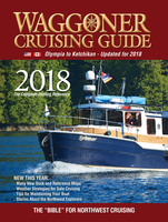
Waggoner Cruising Guide 2018

From south Puget Sound to Ketchikan, Alaska including the west coast of Vancouver Island, this popular annual guide—called the “bible for Northwest cruising”— provides detailed information about marinas, marine parks, fuel docks, U.S./Canada border crossings, customs, VHF radio requirements, and more.Some popular cruising areas covered:Puget Sound (includes Hood Canal)San Juan IslandsCanadian Gulf Islands (including Victoria)Vancouver and Howe SoundPrincess Louisa InletDesolation SoundJohnstone Strait and adjacent waterwaysQueen Charlotte Strait and adjacent waterwaysWest Coast of Vancouver IslandHaida GwaiiInside Passage North to Ketchikan, Alaska
RIP - This product is no longer available on our network. It was last seen on 25.09.2019

This page now acts as a permanent archive for this product. Add more information using the comments box below to ensure it can still be found by future generations.

Use our search facility to see if it is available from an alternative contributor.
  • Availability: Out Of Stock
  • Supplier: Stanfords
  • SKU: 9780996979993
Availability: In Stock
£25.00

Product Description

From south Puget Sound to Ketchikan, Alaska including the west coast of Vancouver Isl&, this popular annual guide—called the “bible for Northwest cruising”— provides detailed information about marinas, marine parks, fuel docks, U.S./ Canada border crossings, customs, VHF radio requirements, & more. Some popular cruising areas covered: Puget Sound (
Includes: Hood Canal) San Juan Islands Canadian Gulf Islands (including Victoria) Vancouver & Howe Sound Princess Louisa Inlet Desolation Sound Johnstone Strait & adjacent waterways Queen Charlotte Strait & adjacent waterways West Coast of Vancouver Island Haida Gwaii Inside Passage North to Ketchikan, Alaska

Reviews/Comments

Add New

Intelligent Comparison

Oooops!
We couldn't find anything!
Perhaps this product's unique.... Or perhaps we are still looking for comparisons!
Click to bump this page and we'll hurry up.

Price History

Vouchers

No voucher codes found.
Do you know a voucher code for this product or supplier? Add it to Insights for others to use.

Facebook

Jargon Buster

Radio - A device used for listening to audio transmissions
fuel - A material used to generate energy.
Popular - Something that is admired and liked by many people.

Supplier Information

Stanfords
Stanfords was established in 1853 and opened their iconic Covent Garden flagship store in 1901. They have become the top retailer of maps, travel books and accessories in the UK and arguably offer the largest selection of maps and travel books worldwide. Famous names such as Captain Robert Falcon Scott, Ranulph Fiennes and Michael Palin have purchased from Stanfords. They now have a shop in Bristol and both stores together with other venues operate a calendar of events including talks, book signings and exhibitions. As a specialist map retailer, the map selection is comprehensive and includes road maps, street maps and walking maps from worldwide destinations, as well as a selection of world atlases and wall maps. Books include travel guides and travel literature. Stanfords also stock globes, from miniatures made of blue marble to magnificent floor-standing globes. The website features a selection of interesting articles on travel topics.
Page Updated: 2023-11-12 20:15:36

Community Generated Product Tags

Oh No! The productWIKI community hasn't generated any tags for this product yet!
Menu