More From Contributor
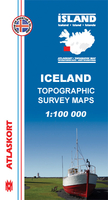
£8.99
During much of his life Voltaire`s plays & verse made him the toast of society, but his barbed wit & commitment to reason also got him into trouble. Jailed twice & eventually banished by the King, he was an outspoken critic of religious intolerance & persecution. His personal life was as colourful as his intellectual one. Voltaire never married, but had long-term affairs with two women: Emilie, who died after giving birth to the child of another lover, & his niece, Marie-Louise, with whom he spent his last twenty-five years. With its tales of illegitimacy, prison, stardom, exile, love affairs & tireless battles against critics, Church & King, Roger Pearson`s brilliant biography brings Voltaire vividly to life. ...
Archived Product
£11.99
Volterra & its environs at 1:25, 000 in a series of hiking maps from Edizioni Multigraphic covering Tuscany, parts of Umbria, & the adjoining areas. The cartography is rather old fashioned & sometimes not as clear as in the other map series but for many areas, especially for parts of Tuscany, these are the only hiking maps available. Most maps have contours at 25-metre intervals, with some relief shading & colouring for forests. An overprint highlights hiking paths, including all the popular hiking routes such as the Grandi Sentieri della Provincia di Siena, etc. The overprint also shows campsites &, where appropriate, mountain refuges & other types of alpine accommodation. Some of the maps indicate latitude & longitude at the map corners, but with longitude sometimes based on Rome rather than Greenwich. Map legends vary, most maps include English. Some maps include street plans & additional notes on the region. IN THIS TITLE: the map has contours at 25m intervals & spot heights. Waymarked footpaths are highlighted. No geographical coordinates are provided. On the reverse is an indexed street plan of Volterra with a list of 18 places of interest highlighted on it. Also provided are notes about the town & its sights. Map legend & the notes include English. ...
Archived Product
£12.99
Lonely Planet`s ” Volunteer
- A Traveller`s Guide to Making a Difference Around the World” is a comprehensive handbook on volunteering
...
Archived Product
£5.99
Administrative provinces of the Ukraine on indexed road maps at 1:250, 000, each with a town centre street plan of its capital city. All place names are in Cyrillic only, but the map legend

Includes::
English. Coverage of the larger provinces is divided between the two sides of the map. Road network is presented in great detail, from international roads, shown with their E numbers, to dirt roads & country paths. Driving distances are marked on main, secondary & selected local roads; the maps also show border crossings, fuel stations, car service stations, & traffic patrol service points. Railway lines are shown with stations & local airports are marked. The maps also show boundaries of districts into which each region (oblast) is subdivided, & indicate their administrative headquarters. Topography is indicated by spot height, plus boundaries of national parks & other protected areas, & colouring and/or graphics for forests, orchards, vineyards, swamps & salt marshes. The maps have latitude & longitude lines at 10’ & 15’ respectively, & are indexed. Map legend

Includes::
English. Each title also

Includes::
a local table of driving distances & a street plan of the region’s administrative capital annotated with locations of selected hotels, car parks & petrol stations, museums & monuments, etc. In some titles more street plans are included.IMPORTANT
- PLEASE NOTE: supplies of all maps published by the Kartografija in Kiev are irregular & we cannot guarantee a definite delivery time for titles currently not in stock. To see the list of other titles in this series please click on the series link.


...
Archived Product
£9.99
The Maverick`s surf point near Half Moon Bay, California, is one of the most dangerous places in the world to catch a ride on a wave. It is also the site of the ultimate challenge of big wave surfing: the Maverick`s Surf Contest. Mark Kreidler takes the reader inside the fifty-foot waves of Maverick`s & inside the lives of the competitors who challenge them. He introduces the reader to the man who first dared to ride a wave at Maverick`s, Jeff Clark. Kreidler`s riveting account of the 2010 season captures the jaw-dropping performance of South Africa`s Chris Bertish
- who was the best of twenty-four surfers amid the biggest waves many had ever seen
- as well as Clark`s clashes with the contest`s management. A thrilling account of the culture of high-risk, high-adrenaline athletes, The Voodoo Wave is also a story of what happens when love of the endeavour collides with the realities of business in the twenty-first century.

...
Archived Product
£10.99
One of the titles in a series of provincial topographic maps derived from generalising the cartography of the 1:50, 000 survey. Topography is shown by contours at 100m intervals, spot heights, hill-shading & graphic relief. Colours & graphics distinguish landscape types e.g. forests, vineyards, swamps. The attractive, finely-drawn detail

Includes::
minor roads, tracks, railways, chairlifts, water features, national parks, & administrative boundaries. Small symbols show many landmarks e.g. towers, castles, refuges, isolated buildings. Some of the place names are in very small print. The maps have a UTM grid, with latitude lines at intervals of 12` & logintude at 20`. Map legend

Includes::
English. Each title also

Includes::
a small map with administrative sub-divisions of the province.


...
Archived Product
£10.95
Map No. 292, Vorarlberg (2-map set), including a nature guide to local wild flowers, in a series of hiking maps from Kompass providing extensive coverage of Austria & Germany plus the Slovenian Alps, with hiking routes on a topographic base, various types of accommodation, recreational facilities, places of interest, etc. Many titles are now published as competitively priced sets of two or more maps, offering a wider coverage. Kompass are Europe ...
Archived Product
£12.99
Tyrol & Vorarlberg provinces of Austria on an indexed, double-sided touring map at 1:175, 000 from Hallwag Kümmerly + Frey, printed on durable, waterproof & tear-resistant synthetic paper. Coverage, with a generous overlap between the sides, extends from Lake Constance eastwards across the Austrian Alps to popular holiday resorts of Zell am See & Kaprun, the peaks of the Glockner massif & Lienz. North/south the map extends from the German Alps to Bressanone/ Brixen in the Italian South Tyrol. Clear & easy to read road network highlights scenic roads & indicates motorway junction numbers & services, steep gradients & winter closures, roads not recommended to or closed to caravans, etc. Driving distances are marked on main & on most connecting local routes. Railway lines are shown with stations & include heritage tourist routes. Various places of interest are highlighted. The map also indicates campsites & youth hostels. Topography is presented by light, unobtrusive relief shading with plenty of names of mountain ranges, etc, plus colouring for woodlands & boundaries of national/natural parks. The map is indexed & has latitude & longitude lines at intervals of 10’. Map legend

Includes::
English. To see other maps in this series please click on the series link.

...
Archived Product
£13.99
Map No. 292, Vorarlberg (2-map set), including a nature guide to local wild flowers, in a series of hiking maps from Kompass providing extensive coverage of Austria & Germany plus the Slovenian Alps, with hiking routes on a topographic base, various types of accommodation, recreational facilities, places of interest, etc. Many titles are now published as competitively priced sets of two or more maps, offering a wider coverage. Kompass are Europe’s largest publishers of walking maps, with extensive coverage of hiking areas in other countries, all listed on our website. * Cartography:* all the maps are contoured with additional shading & graphic relief to provide a more detailed picture of the terrain, vegetation and/or land use. Contour interval varies from 10 metres in the coastal areas of Northern Germany to 40 or 50 metres in the mountainous parts of the two countries. All the maps highlight local & long-distance waymarked footpaths, including climbing trails. Most titles also show cycling routes, mountain bike trails, &, the in mountainous areas, ski routes. The maps indicate various types of accommodation (selected inns & hotels, youth hostels, campsites, mountain refuges), as well as recreational facilities, places of interest, etc. New editions also show access by public transport with bus stops and/or Park+ Ride facilities.* Geographical coordinates:* unless indicated to the contrary in the individual description, the maps have a UTM grid for GPS users. * Map legend:* most maps now include full English legend, particularly titles covering the Alpine areas. Some maps covering mainly eastern Austria or the less popular parts of Germany may still have a legend in German only.* Other
Features:* some titles now include on the reverse panorama drawings of their area with names of villages, peaks, valleys, etc. and/or have booklets with pictures of local wild flowers with their Latin names.*PLEASE NOTE BEFORE ORDERING!* * Booklets:* many titles come with booklets describing the area and/or various hiking routes. These booklets are in * German only*, apart from a handful of titles where an English language booklet is specifically indicated in the individual description. So, unless English language booklet is actually mentioned, the map can only be supplied with a German booklet. These booklets are not necessary to use the maps since, as stated above, most titles now include * full English language map legend.*
...
Archived Product
£9.99
Vorarlberg on a detailed road map at 1:100, 000 from Freytag & Berndt with numerous cycling routes, indicating unpaved paths, routes with heavy motorized traffic & gradient marking. Symbols mark various types of accommodation, including campsites & youth hostels, bike retail & repair facilities, viewpoints, places of interest, etc. Topography is shown by relief shading & spot heights. The map has a 10km UTM grid. On the reverse is an index of localities with their UTM coordinates, plus street plans of main towns & profiles of selected routes. Map legend & all the text include English. To see the list of titles in this series please click on the series link. ...
Archived Product

Vopnafjörður

Vopnafjörður, map no. 28, in the topographic survey of Iceland at 1:100, 000 published by Mál og menning, with excellent, vivid presentation of the terrain, footpaths and bridleways, campsites, etc. The maps have contours at 20m intervals, enhanced by bold relief shading plus colouring and/or graphics to show glaciers, lava fields, sands and mudflats, as well as to distinguish land with vegetation cover from the more sparsely covered terrain. The series provides a splendid presentation of the country’s topography, with large amount of detail and over 43, 000 place names.Road network indicates gravel roads and includes country tracks. Also marked are local footpaths, clear to see with their distinctive colouring, and bridleways. Symbols shows campsites, tourist huts or
shelters, emergency shelters, summer houses, river fords, golf courses and swimming pools, hydro-electric or thermal power stations, local airports, etc, and detail such as individual farms, abandoned farms or ruins, sheepfolds, etc. Each map covers an area of 84 x 67km (53 x 42 miles approx.) and has latitude and longitude lines drawn at intervals of 2’ and 5’ respectively. Map legend includes English, German and French.To see the other titles in this series please click on the series link.
RIP - This product is no longer available on our network. It was last seen on 25.09.2019

This page now acts as a permanent archive for this product. Add more information using the comments box below to ensure it can still be found by future generations.

Use our search facility to see if it is available from an alternative contributor.
  • Availability: Out Of Stock
  • Supplier: Stanfords
  • SKU: 9789979331445
Availability: In Stock
£14.99

Product Description

Vopnafjörður, map no. 28, in the topographic survey of Iceland at 1:100, 000 published by Mál og menning, with excellent, vivid presentation of the terrain, footpaths & bridleways, campsites, etc. The maps have contours at 20m intervals, enhanced by bold relief shading plus colouring and/or graphics to show glaciers, lava fields, sands & mudflats, as well as to distinguish land with vegetation cover from the more sparsely covered terrain. The series provides a splendid presentation of the country’s topography, with large amount of detail & over 43, 000 place names. Road network indicates gravel roads &

Includes::
country tracks. Also marked are local footpaths, clear to see with their distinctive colouring, & bridleways. Symbols shows campsites, tourist huts or shelters, emergency shelters, summer houses, river fords, golf courses & swimming pools, hydro-electric or thermal power stations, local airports, etc, & detail such as individual farms, abandoned farms or ruins, sheepfolds, etc. Each map covers an area of 84 x 67km (53 x 42 miles approx.) & has latitude & longitude lines drawn at intervals of 2’ & 5’ respectively. Map legend

Includes::
English, German & French. To see the other titles in this series please click on the series link.

Reviews/Comments

Add New

Intelligent Comparison

Oooops!
We couldn't find anything!
Perhaps this product's unique.... Or perhaps we are still looking for comparisons!
Click to bump this page and we'll hurry up.

Price History

Vouchers

No voucher codes found.
Do you know a voucher code for this product or supplier? Add it to Insights for others to use.

Facebook

Jargon Buster

Electric - A general term for the flow of electric charge
Summer - The season between Spring and Autumn. Usually the hottest season of the year
Graphics - A general term for visual aspects of an item/display
Gravel - A size of rock between 2mm and 64mm
Network - A link and communication between things. Often computers or people.
Large - something that takes up more space than normal.
Road - a manmade lane or a path that is used to speed up travel.
Golf - A sport played on a large outside grass course, the aim to hit a small ball with a club into small holes.
Individual - A single separate item or person.

Supplier Information

Stanfords
Stanfords was established in 1853 and opened their iconic Covent Garden flagship store in 1901. They have become the top retailer of maps, travel books and accessories in the UK and arguably offer the largest selection of maps and travel books worldwide. Famous names such as Captain Robert Falcon Scott, Ranulph Fiennes and Michael Palin have purchased from Stanfords. They now have a shop in Bristol and both stores together with other venues operate a calendar of events including talks, book signings and exhibitions. As a specialist map retailer, the map selection is comprehensive and includes road maps, street maps and walking maps from worldwide destinations, as well as a selection of world atlases and wall maps. Books include travel guides and travel literature. Stanfords also stock globes, from miniatures made of blue marble to magnificent floor-standing globes. The website features a selection of interesting articles on travel topics.
Page Updated: 2023-11-12 20:15:36

Community Generated Product Tags

Oh No! The productWIKI community hasn't generated any tags for this product yet!
Menu